Loading...

Distance:
0.1 Miles / 0.2 km
Type:
Out-and-Back
Difficulty:
Easy
Time to Hike:
~5 minutes
Features:
Surface Type:
Dirt
Park:
Pu'u ka Pele Forest Reserve
Town:
Waimea, Hawaii
Directions:
21.992529, -159.674068
Added:
June 28, 2022
Updated:
July 06, 2022
Please consider making a donation to the Maui Strong Fund to help the victims of Hawaii's recent wildfires.
Loading...
Loading...
47 '

Total Change
40 '

Ascent
42 '

Descent

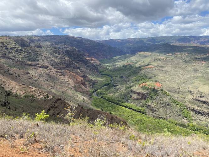
The Waimea Canyon South Lookout at the Pu'u ka Pele Forest Reserve in Waimea, Hawaii (Kauai) is an easy 0.1-mile out-and-back roadside stop that features beautiful views of the southern section of Waimea Canyon.

This is not a hike, but rather a short walk from the road, over the guardrail, to some nice vista points along the canyon's rim. The track depicted here follows some non-official paths that lead to different vantage points.

Parking
Visitors will find parking along the road.

Warning
Slippery terrain: Watch your steps along this trail, especially if visiting in shoes with minimal (or no) grip as one false step could send you falling into the canyon.

Respecting the Land
Hawaiian land is considered sacred to native Hawaiians and many locals, so please stay on-trail, take nothing but photos, and leave nothing but footprints. Respect the locals - don't stay for long and have a backup hike planned in case the parking lot is full.

Explore 51 trails near Waimea, HI
  1. Parking

    21.992529, -159.674068
  2. Main Trailhead

    21.992631, -159.674176
  3. View / Overlook / Vista

    21.992828, -159.674269
    View / Overlook / Vista
No community routes found. To add your own hike as a Community Route for this Trail guide, leave a Trip Report with an attached GPX file.

Hazards

Rockfalls / Ledges / or Scrambles

Seasons

All

Photo Albums

2 Trip Reports

No Star-Ratings
Write-up by:
Admin user profile picture
0.1 miles / 0.2 km
Trail added
June 28, 2022
Hiked on
June 25, 2022
Updated on
July 06, 2022
0.1 miles / 0.2 km
June 25, 2022
Hiking

Weather Forecast

In Waimea, HI

Explore Hiking Trails

New Hikes

Coquina Loop (Old Levi Mill Waterfall)
1.7 Miles
2.7 km
Moderate
Loop
Tibwin Plantation Trail
1.9 Miles
3.1 km
Easy
Out-and-Back
Weston Lake Loop
3.2 Miles
5.1 km
Easy
Loop
Bates Ferry Trail and General Greene Tree
2.7 Miles
4.3 km
Easy
Out-and-Back

Before you leave...

MyHikes is an indie web platform aimed to make exploring public trails easier for everyone. The site has no investors and is owned and operated by one person, Dave Miller (Founder & Admin). As the Founder, main contributor, and doer-of-all-things for MyHikes, I share my trips with over-detailed write-ups for fun on a volunteer basis and I believe that public trail information should be available to everyone.

It takes a lot of time 🕦, money 💰, and effort (including espresso shots ☕) to run MyHikes, including hiking , mapping , writing , and publishing new trails with high-quality content... along with building new features, moderating, site maintainance, and app development for iOS and Android . I simply ask that if you find MyHikes' trail guides helpful to please consider becoming a Supporter to help keep the site, iOS, and Android apps available to everyone.

Supporters unlock website and in-app perks with a one-time payment of $25 (you renew) 😎👍. Or you can simply make a Donation of your choice without a MyHikes user account. Otherwise, telling your friends about MyHikes is the next-best thing - both quick and free 🎉

Thanks for visiting MyHikes and have a great hike!️

Admin user profile picture

Dave Miller
MyHikes Founder & Admin