Loading...

Distance:
0.1 Miles / 0.2 km
Type:
Out-and-Back
Difficulty:
Easy
Time to Hike:
~5 minutes
Features:
Surface Type:
Dirt
Town:
Hana, Hawaii
Directions:
20.683102, -156.030381
Added:
August 28, 2018
Updated:
November 13, 2018
Please consider making a donation to the Maui Strong Fund to help the victims of Hawaii's recent wildfires.
Loading...
Loading...
45 '

Total Change
50 '

Ascent
50 '

Descent

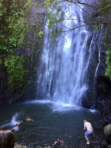
The Wailua Falls Trail in Hana, Maui, Hawaii is a tiny 0.1 mile out-and-back walk to the base of Wailua Falls - an 80 foot waterfall that sits next to the Hana Highway.

This is a popular swimming spot, but beware of flash flooding during heavy rains. The trail is short, but not easy to navigate as you have to scramble down and over rocks to reach the base of Wailua Falls.

If you just want to enjoy the waterfall, you can see almost the entire thing from the road.

Parking: a larger parking lot can be found just south of the falls along the road.

Respecting the Land
Hawaiian land is considered sacred to native Hawaiians and many locals, so please stay on-trail, take nothing but photos, and leave nothing but footprints. Respect the locals - don't stay for long and have a backup hike planned in case the parking lot is full.

Explore 33 trails near Hana, HI
  1. Parking

    20.683102, -156.030381
  2. Main Trailhead

    20.683503, -156.030326
  3. Wailua Falls

    20.68345, -156.030639
    Wailua Falls
No community routes found. To add your own hike as a Community Route for this Trail guide, leave a Trip Report with an attached GPX file.

Seasons

All

Photo Albums

1 Trip Report

No Star-Ratings
Write-up by:
Admin user profile picture
0.1 miles / 0.2 km
Trail added
August 28, 2018
Hiked on
August 17, 2018
Updated on
November 13, 2018

Weather Forecast

In Hana, HI

Explore Hiking Trails

New Hikes

Weston Lake Loop
3.2 Miles
5.1 km
Easy
Loop
Battery Warren Trail
1 Mile
1.6 km
Easy
Out-and-Back
Cameron Overlook Hike
3.3 Miles
5.3 km
Easy
Out-and-Back
Double Run to Canyon Vista Loop
3.7 Miles
6 km
Moderate
Loop

Before you leave...

MyHikes is an indie web platform aimed to make exploring public trails easier for everyone. The site has no investors and is owned and operated by one person, Dave Miller (Founder & Admin). As the Founder, main contributor, and doer-of-all-things for MyHikes, I share my trips with over-detailed write-ups for fun on a volunteer basis and I believe that public trail information should be available to everyone.

It takes a lot of time 🕦, money 💰, and effort (including espresso shots ☕) to run MyHikes, including hiking , mapping , writing , and publishing new trails with high-quality content... along with building new features, moderating, site maintainance, and app development for iOS and Android . I simply ask that if you find MyHikes' trail guides helpful to please consider becoming a Supporter to help keep the site, iOS, and Android apps available to everyone.

Supporters unlock website and in-app perks with a one-time payment of $25 (you renew) 😎👍. Or you can simply make a Donation of your choice without a MyHikes user account. Otherwise, telling your friends about MyHikes is the next-best thing - both quick and free 🎉

Thanks for visiting MyHikes and have a great hike!️

Admin user profile picture

Dave Miller
MyHikes Founder & Admin