Loading...

Distance:
0.2 Miles / 0.3 km
Type:
Out-and-Back
Difficulty:
Easy
Time to Hike:
~6 minutes
Features:
Surface Type:
Dirt
Park:
Wagner Falls Scenic Site
Town:
Munising, Michigan
Directions:
46.388885, -86.649061
Added:
September 25, 2022
Updated:
October 05, 2022
Loading...
Loading...
28 '

Total Change
8 '

Ascent
8 '

Descent

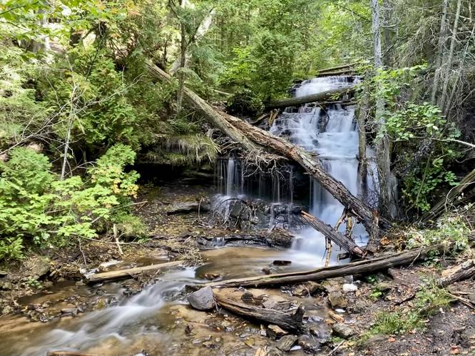
Wagner Falls at the Wagner Falls Scenic Site in Munising, Michigan is an easy 0.2-mile out-and-back hike that leads to the 30-foot tall multi-tier waterfall, Wagner Falls.

This is less of a hike and more of a quick walk that leads to a viewing platform at the base of Wagner Falls. The trail is mostly flat with gravel for substrate that runs along Wagner Creek, passing some old-growth eastern hemlock trees along the way to reach Wagner Falls. Hikers will reach a small set of stairs that leads up to the viewing platform at the base Wagner Falls. Wagner Falls cascades down a series of bedrock ledges, making for a ~30-foot tall waterfall.

Parking
Hikers will find parking at the coordinates provided. The lot is a large turnout area large enough to fit a half-dozen vehicles. On the opposite side of the road is another parking turnout of a similar size.

Pets
Dogs are allowed if leashed and their waste must be carried out by the hiker.

Explore 9 trails near Munising, MI
  1. Parking

    46.388885, -86.649061
  2. Main Trailhead

    46.388775, -86.649167
  3. Wagner Fals, approx. 30-feet tall mutli-tier waterfall (long exposure)

    46.387994, -86.647509
     Wagner Fals, approx. 30-feet tall mutli-tier waterfall (long exposure)
No community routes found. To add your own hike as a Community Route for this Trail guide, leave a Trip Report with an attached GPX file.

Hazards

Ticks - Lyme Disease More Info (CDC)
Poison Ivy/Oak

Seasons

All

Photo Albums

2 Trip Reports

No Star-Ratings
Write-up by:
Admin user profile picture
0.2 miles / 0.3 km
Trail added
September 25, 2022
Hiked on
September 21, 2022
Updated on
October 05, 2022
0.2 miles / 0.3 km
September 21, 2022
Hiking

Weather Forecast

In Munising, MI

Explore Hiking Trails

New Hikes

Diana's Baths Trail
1.2 Miles
1.9 km
Easy
Out-and-Back
Tibwin Plantation Trail
1.9 Miles
3.1 km
Easy
Out-and-Back
Angel Falls Loop
2.8 Miles
4.5 km
Moderate
Loop
Battery Warren Trail
1 Mile
1.6 km
Easy
Out-and-Back

Before you leave...

MyHikes is an indie web platform aimed to make exploring public trails easier for everyone. The site has no investors and is owned and operated by one person, Dave Miller (Founder & Admin). As the Founder, main contributor, and doer-of-all-things for MyHikes, I share my trips with over-detailed write-ups for fun on a volunteer basis and I believe that public trail information should be available to everyone.

It takes a lot of time 🕦, money 💰, and effort (including espresso shots ☕) to run MyHikes, including hiking , mapping , writing , and publishing new trails with high-quality content... along with building new features, moderating, site maintainance, and app development for iOS and Android . I simply ask that if you find MyHikes' trail guides helpful to please consider becoming a Supporter to help keep the site, iOS, and Android apps available to everyone.

Supporters unlock website and in-app perks with a one-time payment of $25 (you renew) 😎👍. Or you can simply make a Donation of your choice without a MyHikes user account. Otherwise, telling your friends about MyHikes is the next-best thing - both quick and free 🎉

Thanks for visiting MyHikes and have a great hike!️

Admin user profile picture

Dave Miller
MyHikes Founder & Admin