Upper Pine Bottom Falls at Upper Pine Bottom State Park near Jersey Mills, Pennsylvania is an easy 0.2-mile out-and-back walk that leads to a small waterfall.
This is not a hike, but rather a quick walk through the main section of Upper Pine Bottom State Park that features a waterfall, picnic areas, fishing opportunities, and scenic rhododendron that line the creek's banks. Hikers will notice that Upper Pine Bottom State Park is very small, but is still a nice stop to take a break or enjoy the scenic water features on a long drive. There's a skinny path that leads along the rhododendron along Upper Pine Bottom Run heading west, however it ends fairly quickly and is likely just a path for fishermen.
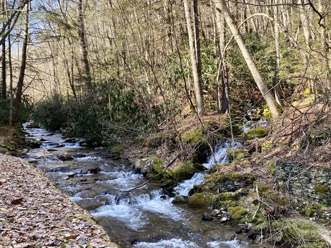
Upper Pine Bottom Falls
The main attraction, aside from fishing, for visitors here is the small but scenic waterfall nicknamed Upper Pine Bottom Falls. This waterfall cascades into Upper Pine Bottom Run via an unnamed creek that spills down the mountainside. Upper Pine Bottom Falls is a multi-tiered cascade that is not much more than 8-feet tall in the visible section. The waterfall is mostly visible when the leaves are off of the trees and to get the best view of the waterfall, hikers must be in Upper Pine Bottom Run; however, you can still enjoy the cascades from the large human-made flood protection banks that line the creek here.
Pets
Dogs are allowed if leashed and their waste must be carried out by the hiker.
Parking
Visitors will find parking at the coordinates provided. The lot is large enough to fit about 10 cars or less.
Features
Fishing, picnic tables, small waterfall.
This is not a hike, but rather a quick walk through the main section of Upper Pine Bottom State Park that features a waterfall, picnic areas, fishing opportunities, and scenic rhododendron that line the creek's banks. Hikers will notice that Upper Pine Bottom State Park is very small, but is still a nice stop to take a break or enjoy the scenic water features on a long drive. There's a skinny path that leads along the rhododendron along Upper Pine Bottom Run heading west, however it ends fairly quickly and is likely just a path for fishermen.
Upper Pine Bottom Falls
The main attraction, aside from fishing, for visitors here is the small but scenic waterfall nicknamed Upper Pine Bottom Falls. This waterfall cascades into Upper Pine Bottom Run via an unnamed creek that spills down the mountainside. Upper Pine Bottom Falls is a multi-tiered cascade that is not much more than 8-feet tall in the visible section. The waterfall is mostly visible when the leaves are off of the trees and to get the best view of the waterfall, hikers must be in Upper Pine Bottom Run; however, you can still enjoy the cascades from the large human-made flood protection banks that line the creek here.
Pets
Dogs are allowed if leashed and their waste must be carried out by the hiker.
Parking
Visitors will find parking at the coordinates provided. The lot is large enough to fit about 10 cars or less.
Features
Fishing, picnic tables, small waterfall.