Upper and Middle Falls at Letchworth State Park near Portageville, New York is an easy 0.9-mile out-and-back walk that features two massive waterfalls that plummet through the gorge — the 70-foot tall Upper Falls and 107-foot Middle Falls. Exploring Letchworth's Upper Falls
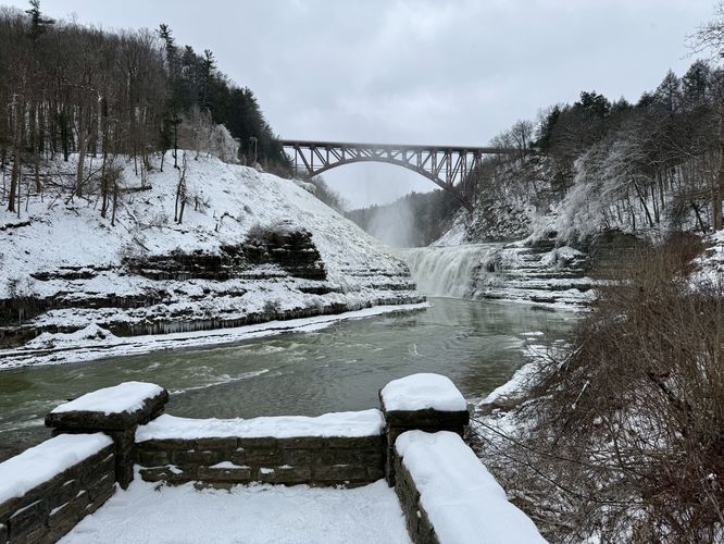
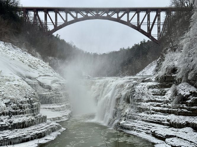
The first stop along this route is Upper Falls, which sits just a stone's throw away from the parking lot. At the parking lot, hop on the Gorge Trail and follow the pink blazes south, toward the sound of rushing water, to find the 70-foot tall Upper Falls cascading down the bedrock of the Letchworth Gorge. Upper Falls sits perfectly below the Genesee Arch Bridge, which provides one the most scenic views in the gorge as both the bridge and waterfall project each other's size and scale to the visitor. Upper Falls has several lookout points, but the best — in my opinion — sits closest to the slopes of the gorge so it's worth walking just a bit further to check out this view, located around mile 0.16 in the route provided.
Fast moving water: In addition to fall dangers, this trail runs along the scenic but deadly Genesee River. The shale banks of the gorge do not provide much safety for curious visitors who want to explore the river. In addition to drowning risks, if you get injured and swept downstream there are massive waterfalls with huge drops that are not survivable. Always stay on-trail here.
Trails
This walk follows the Gorge Trail (pink blazes).Exploring Letchworth's Upper Falls
The first stop along this route is Upper Falls, which sits just a stone's throw away from the parking lot. At the parking lot, hop on the Gorge Trail and follow the pink blazes south, toward the sound of rushing water, to find the 70-foot tall Upper Falls cascading down the bedrock of the Letchworth Gorge. Upper Falls sits perfectly below the Genesee Arch Bridge, which provides one the most scenic views in the gorge as both the bridge and waterfall project each other's size and scale to the visitor. Upper Falls has several lookout points, but the best — in my opinion — sits closest to the slopes of the gorge so it's worth walking just a bit further to check out this view, located around mile 0.16 in the route provided.Exploring Letchworth's Middle Falls
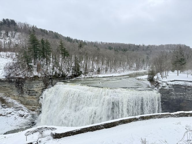
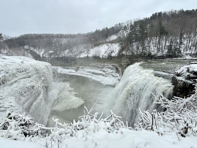
After checking out the scenery of Upper Falls, Middle Falls is the next stop along this route. Simply walk north along the Gorge Trail to find the top of Middle Falls as it plummets over a 107-foot tall cliff, around mile 0.5. This view from the stone staircase provides visitors with stunning scenery of Letchworth's tall cliffs with the glassy water of the Genesee River just before it slips over the edge. Walk down the stairs just a bit further and follow the trail as it bends around the cliff side — here, around mile 0.53, sits an amazing view of the 107-foot tall Middle Falls along with a view of the sheer cliffs of the gorge. During winter, this scenery is unmatched as the spray from the waterfall freezes and clings to the 100-foot tall cliffs directly across from the plummeting cascade. The last view along this walk leads up the exit road — as during the winter, the official trail that runs alongside the gorge's cliffs is closed. Around mile 0.6, you'll reach a great view of Middle Falls from the road — or from the trail, if exploring when the trail is not officially closed. After exploring Middle Falls, this route wraps up back at the parking lot for a short and easy 0.9-mile out-and-back walk.Parking & Fees
Visitors will find a very large parking lot at the coordinates provided, located at the southern end of Upper Middle Falls Road in the park. The lot is large enough to fit many dozens of vehicles as of January 2025. To enter Letchworth State Park, during seasonal ticketing, as of 2024 the entry fee is $10 per vehicle.Pets
Dogs are allowed only if leashed and must be cleaned up after.Warnings
Steep cliffs: Always stay on-trail for this walk to ensure your own safety. Some of the cliffs at Letchworth are sheer drops of over 100-feet.Fast moving water: In addition to fall dangers, this trail runs along the scenic but deadly Genesee River. The shale banks of the gorge do not provide much safety for curious visitors who want to explore the river. In addition to drowning risks, if you get injured and swept downstream there are massive waterfalls with huge drops that are not survivable. Always stay on-trail here.