Upper Indian Ladders Waterfalls Hike at Delaware Water Gap National Recreation Area near Dingmans Ferry, Pennsylvania is a moderate 0.9-mile out-and-back hike that features several waterfalls within the Upper Indian Ladders cascades including a ~40-foot waterfall.
Hike Description
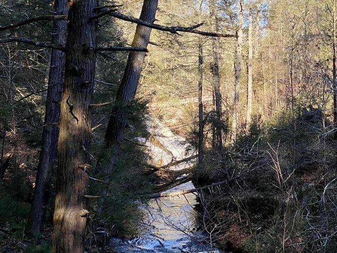
This hike begins at the main trailhead for the Upper Hornbecks Creek Trail and follows that path heading south. The trail passes through an open forest with a steep ravine to the east -- hikers will be able to hear, but not see, a ~40-foot waterfall that spills down the creek, located fairly close to the trailhead.
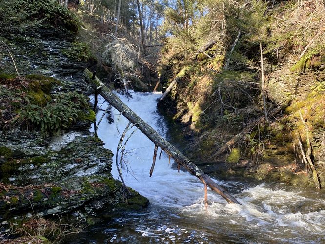
Upstream Waterfall View - Mile 0.17
Located off-trail, and during seasons with no leaves on the trees, hikers will find a view facing upstream of the ~40-foot waterfall that you heard while hiking down the trail. This cascade is virtually impossible to reach from this side of the trail, so continue hiking down the path to reach more accessible waterfalls.
Upper Indian Ladders - Mile 0.3 to 0.45
As hikers make their way down the trail, they'll hit several waterfalls along the way. This series of waterfalls is known collectively as the Upper Indian Ladders.
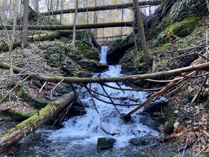
15-foot Gorge Waterfall - Mile 0.3
Hikers will reach an off-trail path that leads down to the gorge, around mile 0.3. At the end, you'll find a ~15-foot cascade that spills down the scenic gorge. Watch your step; however, due to the slick and slippery bedrock that sits in the bottom of the gorge, with minimal standing area.
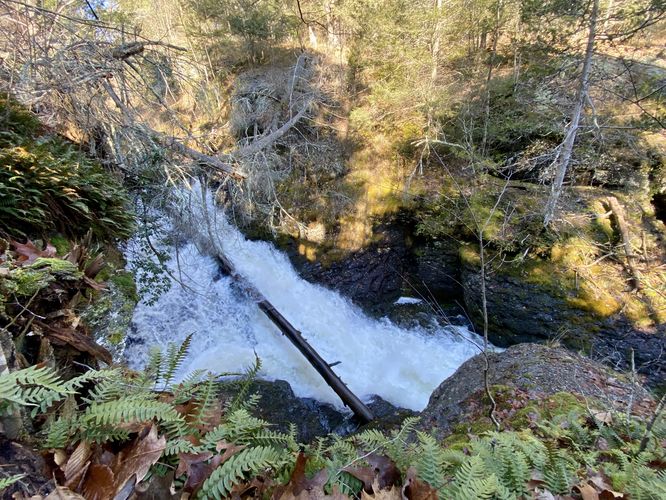
Top of Waterfall - Mile 0.35
After hopping back on the trail, the path will hit another switchback before reaching the top of another waterfall that appears to be between 10-20 feet tall that spills down the gorge.
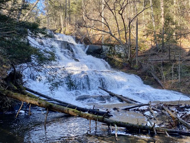
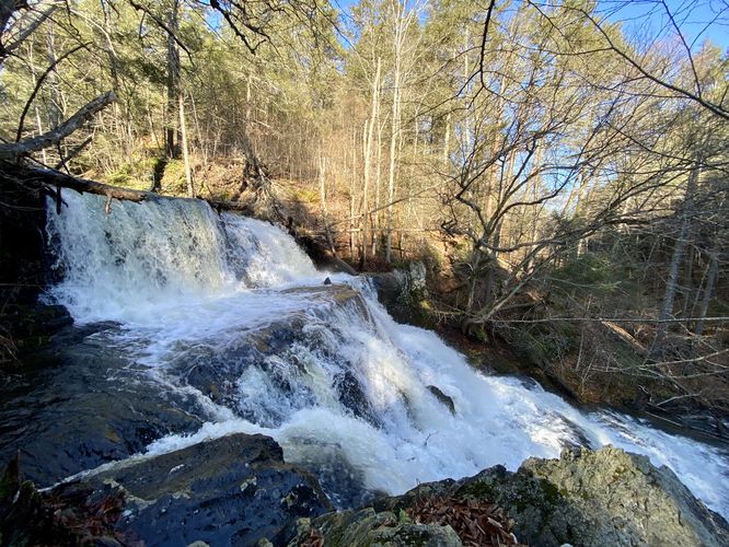
Largest Waterfall of Upper Indian Ladders (40-foot waterfall) - Mile 0.4 to 0.45
At mile 0.4, hikers will head downhill further as they pass the largest waterfall along this hike -- technically the "lower" of the Upper Indian Ladders, which cascades down ~40-feet as it spills over rock ledges within the creek. The trail will head down a large staircase, passing a tributary waterfall that spills down two tiers at about 15-feet tall. This track then ends around mile 0.45 at the creek's convergence. At the creek's convergence is a beautiful view of the 40-foot (largest) waterfall within Upper Indian Ladders. During my hike here in December 2023, I was met with high water after recent rainfall which blocked the trail with 4 inches or more of water. Not looking to get my feet wet, I turned back here.
The hike back to parking is mostly all uphill, hence the moderate difficulty. On the way back you can choose to hit up the same waterfalls you enjoyed on the way in to take more photos or enjoy the scenery.
Parking
Hikers will find a small parking turnout at the coordinates provided. The lot is large enough to fit about 5 vehicles as of December 2023.
Pets
Dogs are allowed only if leashed and must be cleaned up after.
Warnings
Slippery rocks: This hike includes some short off-trail hiking. Some of the off-trail locations include slipper creek side bedrock that can be dangerous if not prepared with the proper footwear and experience.
Hike Description
This hike begins at the main trailhead for the Upper Hornbecks Creek Trail and follows that path heading south. The trail passes through an open forest with a steep ravine to the east -- hikers will be able to hear, but not see, a ~40-foot waterfall that spills down the creek, located fairly close to the trailhead.
Upstream Waterfall View - Mile 0.17
Located off-trail, and during seasons with no leaves on the trees, hikers will find a view facing upstream of the ~40-foot waterfall that you heard while hiking down the trail. This cascade is virtually impossible to reach from this side of the trail, so continue hiking down the path to reach more accessible waterfalls.
Upper Indian Ladders - Mile 0.3 to 0.45
As hikers make their way down the trail, they'll hit several waterfalls along the way. This series of waterfalls is known collectively as the Upper Indian Ladders.
15-foot Gorge Waterfall - Mile 0.3
Hikers will reach an off-trail path that leads down to the gorge, around mile 0.3. At the end, you'll find a ~15-foot cascade that spills down the scenic gorge. Watch your step; however, due to the slick and slippery bedrock that sits in the bottom of the gorge, with minimal standing area.
Top of Waterfall - Mile 0.35
After hopping back on the trail, the path will hit another switchback before reaching the top of another waterfall that appears to be between 10-20 feet tall that spills down the gorge.
Largest Waterfall of Upper Indian Ladders (40-foot waterfall) - Mile 0.4 to 0.45
At mile 0.4, hikers will head downhill further as they pass the largest waterfall along this hike -- technically the "lower" of the Upper Indian Ladders, which cascades down ~40-feet as it spills over rock ledges within the creek. The trail will head down a large staircase, passing a tributary waterfall that spills down two tiers at about 15-feet tall. This track then ends around mile 0.45 at the creek's convergence. At the creek's convergence is a beautiful view of the 40-foot (largest) waterfall within Upper Indian Ladders. During my hike here in December 2023, I was met with high water after recent rainfall which blocked the trail with 4 inches or more of water. Not looking to get my feet wet, I turned back here.
The hike back to parking is mostly all uphill, hence the moderate difficulty. On the way back you can choose to hit up the same waterfalls you enjoyed on the way in to take more photos or enjoy the scenery.
Parking
Hikers will find a small parking turnout at the coordinates provided. The lot is large enough to fit about 5 vehicles as of December 2023.
Pets
Dogs are allowed only if leashed and must be cleaned up after.
Warnings
Slippery rocks: This hike includes some short off-trail hiking. Some of the off-trail locations include slipper creek side bedrock that can be dangerous if not prepared with the proper footwear and experience.