Delphi Falls Upper Trail at Delphi Falls County Park near Cazenovia, New York is a moderate 0.8-mile out-and-back hike that features three overlooks of both Upper and Lower Delphi Falls.
Hike Description
This hike begins at the newly-built parking area (as of Summer 2023) for Delphi Falls County Park, located at the coordinates provided and follows the main trailhead up the series of staircases. The Upper Trail (or East Trail as depicted on the park map) heads up the canyon's hillside at a moderate grade for 0.4-miles one-way. Along the hike are three different overlooks of the waterfalls.
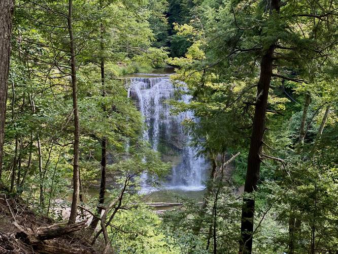
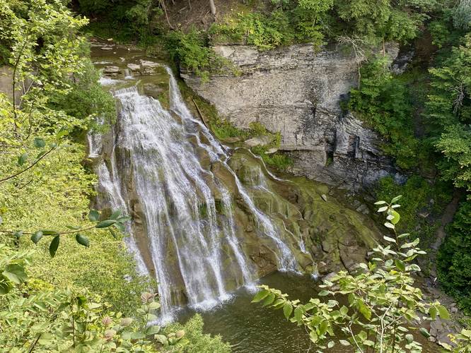
Lower Delphi Falls Overlook - Mile 0.25
Around mile 0.25, hikers will reach the first overlook which features Lower Delphi Falls. Lower Delphi Falls cascades down the creek's bedrock along a gradual slope, fanned-out across several cascading runs and, in my opinion, is the most scenic cascade along the trail.
Upper Delphi Falls Overlook - Mile 0.3
Around mile 0.3, hikers will reach an overlook of Upper Delphi Falls which spills over the creek's bedrock in a free-falling cascade. This overlook features the best view of Upper Delphi Falls, but hikers can get another view of Upper Delphi Falls form the very end of the trail.
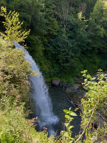
Upper Delphi Falls - Mile 0.4
Around mile 0.4, hikers will reach the top of Upper Delphi Falls which spills over the bedrock in a free-falling cascade at about 60-feet tall (or more). There's a nice viewing platform for hikers to take-in the sights of the canyon and the top of Upper Delphi Falls. From the side of the viewing platform, if you're extremely careful and stay back enough, you can get a view of the waterfall as it cascades over the bedrock.
The hike out, despite the uphill staircase that lead you down to Upper Delphi Falls is easy.
Parking
Hikers will find a large parking lot at the coordinates provided - large enough to fit several dozen vehicles.
Pets
Dogs are allowed only if leashed and must be cleaned up after.
Warning
Steep terrain: Stay on-trail as most of the terrain off-trail is very steep and a slip down could lead to serious injury or worse.
Restrooms
As of August 2023, there are restrooms at the trailhead.
Hike Description
This hike begins at the newly-built parking area (as of Summer 2023) for Delphi Falls County Park, located at the coordinates provided and follows the main trailhead up the series of staircases. The Upper Trail (or East Trail as depicted on the park map) heads up the canyon's hillside at a moderate grade for 0.4-miles one-way. Along the hike are three different overlooks of the waterfalls.
Lower Delphi Falls Overlook - Mile 0.25
Around mile 0.25, hikers will reach the first overlook which features Lower Delphi Falls. Lower Delphi Falls cascades down the creek's bedrock along a gradual slope, fanned-out across several cascading runs and, in my opinion, is the most scenic cascade along the trail.
Upper Delphi Falls Overlook - Mile 0.3
Around mile 0.3, hikers will reach an overlook of Upper Delphi Falls which spills over the creek's bedrock in a free-falling cascade. This overlook features the best view of Upper Delphi Falls, but hikers can get another view of Upper Delphi Falls form the very end of the trail.
Upper Delphi Falls - Mile 0.4
Around mile 0.4, hikers will reach the top of Upper Delphi Falls which spills over the bedrock in a free-falling cascade at about 60-feet tall (or more). There's a nice viewing platform for hikers to take-in the sights of the canyon and the top of Upper Delphi Falls. From the side of the viewing platform, if you're extremely careful and stay back enough, you can get a view of the waterfall as it cascades over the bedrock.
The hike out, despite the uphill staircase that lead you down to Upper Delphi Falls is easy.
Parking
Hikers will find a large parking lot at the coordinates provided - large enough to fit several dozen vehicles.
Pets
Dogs are allowed only if leashed and must be cleaned up after.
Warning
Steep terrain: Stay on-trail as most of the terrain off-trail is very steep and a slip down could lead to serious injury or worse.
Restrooms
As of August 2023, there are restrooms at the trailhead.