Loading...

๐ŸŽ‰ Enjoy a Free 7-Day Supporter Trial and Unlock Exclusive Perks โ€” No Credit Card Required. Learn more.

Upper Canada Falls

Directions
Map
Pictures
Send to App
Distance:
0.1 Miles / 0.2 km
Type:
Out-and-Back
Difficulty:
Moderate
Time to Hike:
~5 minutes
Features:
Surface Type:
Dirt
Park:
Catskill Park
Town:
Middletown, New York
Directions:
42.15259, -74.69919
Added:
September 11, 2023
Updated:
September 12, 2023
Copy Trail Link Hiking this trail? Send a friend or family member a link to this trail guide for your own safety. Hike at your own risk (disclaimer)
Loading...
Loading...
15'

Total Change
15'

Ascent
15'

Descent

Download the Trail Route for Offline Use

Supporters get exclusive access to download trail routes to the MyHikes app for offline use. Stay prepared on your adventure, even without an internet connection! Become a Supporter today to unlock this feature and hike with confidence.

Send to App

Upper Canada Falls

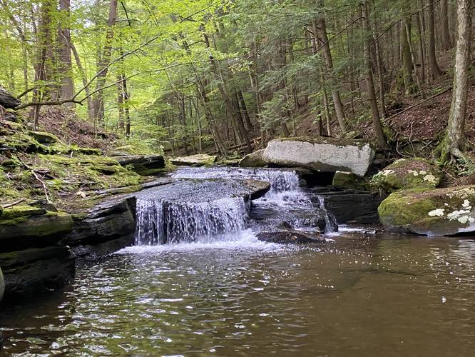
Upper Canada Falls at Catskill Park in Middletown, New York is a moderate hillside scramble that leads to a small but scenic 3-foot tall waterfall.

Hike Description
This is barely a hike as the total distance is less than 0.1-miles; however, this is an off-trail hillside scramble that requires a bit of experience to get down to view the waterfall. I originally came here to explore Canada Falls, which is a larger waterfall in the same creek, located downstream, but the terrain did not seem worth it due to the risks, so I enjoyed Upper Canada Falls instead. Note that to reach the flat bedrock to view the waterfall, hikers must scramble down a ~5-foot drop from a large tree down onto exposed slanted shale bedrock, which can be slippery and dangerous.

The waterfall itself is ~3-feet tall and cascades down into a beautiful pool of water.

Parking
Note that there's no real good parking for this waterfall. Hikers will find enough room near the coordinates provided, located on the east side of the road, where they can fit one or two vehicles maximum.

Pets
Dogs are allowed if leashed, but due to the steep terrain, you should leave them in the car or at home.
Explore 8 trails near Middletown, NY
  1. Parking

    42.15259, -74.69919
  2. Main Trailhead

    42.152535, -74.699175
  3. Upper Canada Falls

    42.152389, -74.699006
    Upper Canada Falls
No community routes found. To add your own hike as a Community Route for this Trail guide, leave a Trip Report with an attached GPX file.

Hazards

Ticks - Lyme Disease More Info (CDC)
Poison Ivy/Oak
Rockfalls / Ledges / or Scrambles

Seasons

All

Weather Forecast

In Middletown, NY

Explore Hiking Trails

You May Also Like

Colorado's Million Dollar Highway - Plan a day's drive adventure along the iconic Million Dollar Highway in Colorado. Explore the best short trails, roadside stops, waterfalls, vistas, ghost towns, and hot springs within a ~6 hour road trip.
Explore

Colorado's Million Dollar Highway

Plan a day's drive adventure along the iconic Million Dollar Highway in Colorado. Explore the best short trails, roadside stops, waterfalls, vistas, ghost towns, and hot springs within a ~6 hour road trip.

Read
Glacier's Going-to-the-Sun Road - Discover the breathtaking beauty of Glacier National Park along the iconic Going-to-the-Sun Road. From stunning roadside stops to picturesque waterfalls and vistas, this engineering marvel offers endless opportunities for exploration.
Explore

Glacier's Going-to-the-Sun Road

Discover the breathtaking beauty of Glacier National Park along the iconic Going-to-the-Sun Road. From stunning roadside stops to picturesque waterfalls and vistas, this engineering marvel offers endless opportunities for exploration.

Read
New York's Best Waterfalls - Whether you're planning a day hike, roadside stop, or a leisurely short walk, this guide provides hikers, travelers, and locals alike with 63 different locations to over 100 scenic waterfalls to help plan your next adventure!
Explore

New York's Best Waterfalls

Whether you're planning a day hike, roadside stop, or a leisurely short walk, this guide provides hikers, travelers, and locals alike with 63 different locations to over 100 scenic waterfalls to help plan your next adventure!

Read

Before you boogie...

Find our trail guides useful? Consider becoming a Supporter to unlock perks!

MyHikes is an indie platform that makes exploring public trails easier for everyone. The platform has no investors, no ads, and is owned and operated by one person, Dave Miller. Dave has personally mapped and written over 1,800 trail guides on MyHikes for the public to explore. MyHikes has helped millions outdoor enthusiasts plan their next adventure.

But it takes a lot of time ๐Ÿ•ฆ, money ๐Ÿ’ฐ, work, and espresso shots โ˜• to run MyHikes, including hiking , mapping , writing , and publishing new trails with high-quality (accurate) information... along with software engineering (coding) the platform like building new features, website and mobile app development (iOS and Android), site maintainance . and much much more.

Supporters unlock website and mobile app perks with an annual one-time payment of $25 (you renew) ๐Ÿ˜Ž๐Ÿ‘. Or you can simply make a Donation of your choice. Otherwise, you can support us by telling your friends about MyHikes - both quick and free ๐ŸŽ‰

Admin user profile picture

Dave Miller
MyHikes Founder