The Upheaval Dome Trail at Canyonlands National Park near Moab, Utah is a moderate 1.4-mile out-and-back hike that features panoramic views of a massive circular-chasm.
Hike Description
This hike begins at the main parking lot for Upheaval Dome, located at the end of Upheaval Dome Road in Canyonlands National Park. The main trailhead is located at the northwest corner of the parking area. Hikers will start by following the Upheaval Dome Trail, keeping left at the first trail junction, and then will head westward along the dirt path as it meanders its way slowly uphill toward the first overlook area.
1st Overlook - Mile 0.3
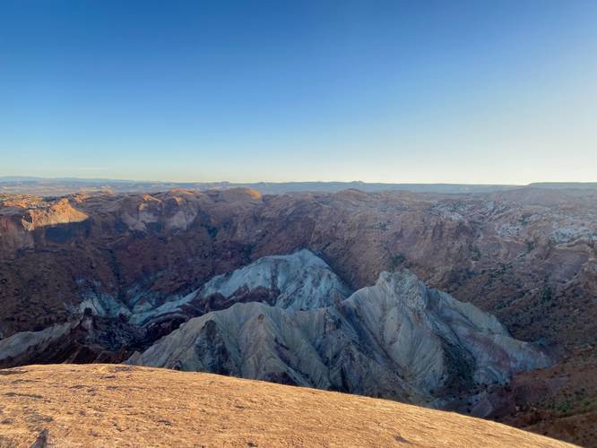
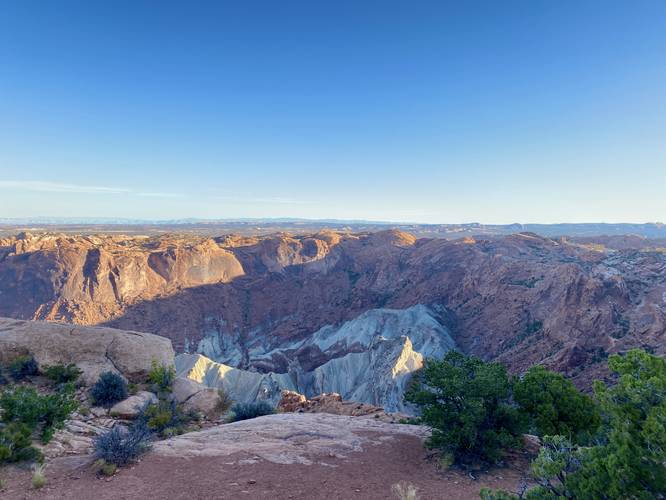
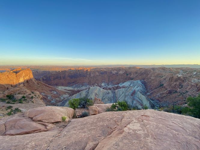
At mile 0.3, hikers will find the first overlook of Upheaval Dome. From here, you'll peer into the massive circular-chasm that spans an approximate 1-mile diameter. As of September 2023, an information kiosk at the 1st overlook provides additional information about how the Upheaval Dome may have been formed. This mystery has yet to be solved; however, scientists believe that either a meteorite impact or a salt dome uplift caused the Upheaval Dome to form -- the latest data favors the meteorite impact hypothesis.
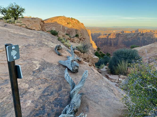
Hiking to the 2nd Overlook - Mile 0.3 to 0.6
After visiting the 1st Upheaval Dome Overlook, hikers will continue heading west along the trail to reach the 2nd Overlook. To be fair, I think the hike to the 2nd Overlook is a lot more exciting and worth-while than the 2nd Overlook itself, so if you don't care to explore beyond the 1st Overlook you aren't missing much. Note that from the 1st Overlook to the 2nd, hikers will follow small stone cairns that define the trail in many places -- some of which are a little bit difficult to spot and follow. The trail leads downhill to reach a short but steep cliff that sits between a "fold" in the bedrock, approximately 5-feet deep or so. There are bedrock-hewn steps that were carved into the bedrock that hikers can walk down on to reach where the trail continues. The trail will then skirt around the Upheaval Dome's cliffs, providing more stunning views into the chasm below. The trail will then follow flat bedrock, marked with low-profile potholes before ascending some somewhat-steep bedrock surfaces -- one of which has another set of bedrock-hewn steps hikers can use to help ascend. The trail will take one more steep bedrock ascent before curving a sharp right-hand turn to reach the "end" of the trail, at the 2nd Overlook.
2nd Upheaval Dome Overlook - Mile 0.7
Around mile 0.7, hikers will reach the top of the 2nd overlook where they'll find plenty of views into the Upheaval Dome. The views from the 2nd Overlook are similar to the views at the 1st Overlook, but it gives hikers a different perspective of this 1-mile wide chasm. Here, hikers can hang out, relax, and eat snacks or take a drink before hiking back to parking.
Parking
Hikers will find parking at the coordinates provided -- located at the end of the Upheaval Dome Road at Canyonlands National Park. The lot is large enough to fit a couple dozen vehicles maximum.
Pets
Dogs are not allowed on any trails at Canyonlands National Park. Please do not bring your dog here.
Warning
Sun exposure: This trail has very little shade and no water sources. Pack-in all water and wear sun screen and a hat to protect against sun exposure. It's smart to hike either in the early morning or late afternoon to avoid the intense desert sun.
No water: This trail has no water sources so you must pack-in all water. A general rule of thumb in the desert is 1 gallon of water per person per day.
Rattlesnakes: This is rattlesnake territory, so be on the lookout and give any rattlers you find plenty of space.
Steep cliffs: This trail follows steep cliffs. Watch your step and give yourself plenty of space from the edge of the cliffs for your own safety.
Fees
Vehicle entry fees to Canyonlands National Park is $30 as of September 2023.
Hike Description
This hike begins at the main parking lot for Upheaval Dome, located at the end of Upheaval Dome Road in Canyonlands National Park. The main trailhead is located at the northwest corner of the parking area. Hikers will start by following the Upheaval Dome Trail, keeping left at the first trail junction, and then will head westward along the dirt path as it meanders its way slowly uphill toward the first overlook area.
1st Overlook - Mile 0.3
At mile 0.3, hikers will find the first overlook of Upheaval Dome. From here, you'll peer into the massive circular-chasm that spans an approximate 1-mile diameter. As of September 2023, an information kiosk at the 1st overlook provides additional information about how the Upheaval Dome may have been formed. This mystery has yet to be solved; however, scientists believe that either a meteorite impact or a salt dome uplift caused the Upheaval Dome to form -- the latest data favors the meteorite impact hypothesis.
Hiking to the 2nd Overlook - Mile 0.3 to 0.6
After visiting the 1st Upheaval Dome Overlook, hikers will continue heading west along the trail to reach the 2nd Overlook. To be fair, I think the hike to the 2nd Overlook is a lot more exciting and worth-while than the 2nd Overlook itself, so if you don't care to explore beyond the 1st Overlook you aren't missing much. Note that from the 1st Overlook to the 2nd, hikers will follow small stone cairns that define the trail in many places -- some of which are a little bit difficult to spot and follow. The trail leads downhill to reach a short but steep cliff that sits between a "fold" in the bedrock, approximately 5-feet deep or so. There are bedrock-hewn steps that were carved into the bedrock that hikers can walk down on to reach where the trail continues. The trail will then skirt around the Upheaval Dome's cliffs, providing more stunning views into the chasm below. The trail will then follow flat bedrock, marked with low-profile potholes before ascending some somewhat-steep bedrock surfaces -- one of which has another set of bedrock-hewn steps hikers can use to help ascend. The trail will take one more steep bedrock ascent before curving a sharp right-hand turn to reach the "end" of the trail, at the 2nd Overlook.
2nd Upheaval Dome Overlook - Mile 0.7
Around mile 0.7, hikers will reach the top of the 2nd overlook where they'll find plenty of views into the Upheaval Dome. The views from the 2nd Overlook are similar to the views at the 1st Overlook, but it gives hikers a different perspective of this 1-mile wide chasm. Here, hikers can hang out, relax, and eat snacks or take a drink before hiking back to parking.
Parking
Hikers will find parking at the coordinates provided -- located at the end of the Upheaval Dome Road at Canyonlands National Park. The lot is large enough to fit a couple dozen vehicles maximum.
Pets
Dogs are not allowed on any trails at Canyonlands National Park. Please do not bring your dog here.
Warning
Sun exposure: This trail has very little shade and no water sources. Pack-in all water and wear sun screen and a hat to protect against sun exposure. It's smart to hike either in the early morning or late afternoon to avoid the intense desert sun.
No water: This trail has no water sources so you must pack-in all water. A general rule of thumb in the desert is 1 gallon of water per person per day.
Rattlesnakes: This is rattlesnake territory, so be on the lookout and give any rattlers you find plenty of space.
Steep cliffs: This trail follows steep cliffs. Watch your step and give yourself plenty of space from the edge of the cliffs for your own safety.
Fees
Vehicle entry fees to Canyonlands National Park is $30 as of September 2023.