Loading...

๐Ÿ Fall is here! Check out our foliage map to plan your autumn hikes! Learn more.

Uncompahgre Falls

Directions
Map
Pictures
Send to App
Distance:
0.1 Miles / 0.2 km
Type:
Out-and-Back
Difficulty:
Moderate
Time to Hike:
~5 minutes
Features:
Surface Type:
Dirt
Park:
Uncompahgre National Forest
Town:
Ouray, Colorado
Get Directions:
37.988221, -107.649946
Added:
June 03, 2024
Updated:
August 01, 2024
Copy Trail Link Hiking this trail? Send a friend or family member a link to this trail guide for your own safety. Hike at your own risk (disclaimer)
Loading...
Loading...
62'

Total Change
68'

Ascent
68'

Descent

Download the Trail Route for Offline Use

Supporters get exclusive access to download trail routes to the MyHikes app for offline use. Stay prepared on your adventure, even without an internet connection! Become a Supporter today to unlock this feature and hike with confidence.

Send to App

Key Takeaways

  • Uncompahgre Falls Trail in Ouray, CO is a short (0.1-mile) but moderate hike offering views of the Uncompahgre Falls and Ouray Valley.
  • The trail follows an unnamed dirt path alongside the Uncompahgre River and features steep drop-offs, requiring caution.
  • Parking is available at a turnout along the Million Dollar Highway, and dogs are permitted on a leash.

Uncompahgre Falls

Uncompahgre Falls at Uncompahgre National Forest near Ouray, Colorado is a moderate 0.1-mile out-and-back hike that leads to the mountainside waterfall known in the Uncompahgre River, Uncompahgre Falls, and a view of the Ouray valley.

Hike
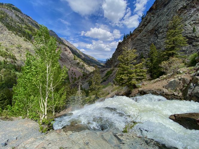
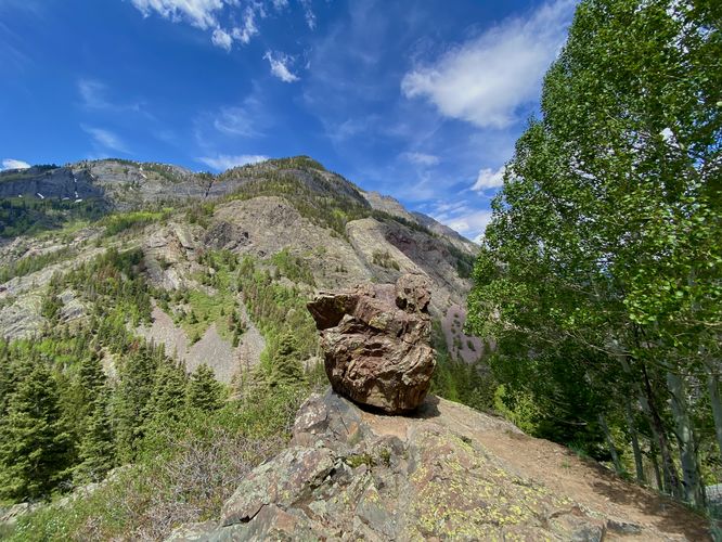
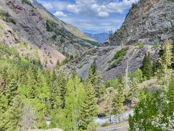
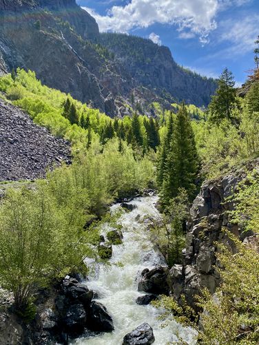
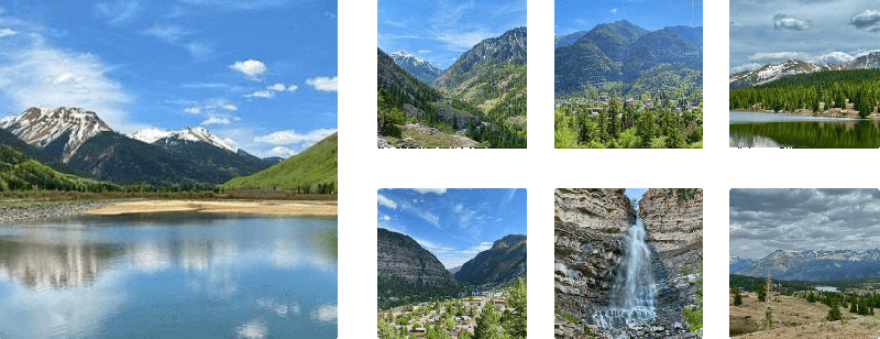
This very short hike begins on the west side of the Million Dollar Highway, near the coordinates provided, and leads downhill along an unnamed dirt trail. Hikers must be careful as the dirt path leads in and around very steep drop-offs and cliff areas. The trail leads down alongside the Uncompahgre River to reach a beautiful view from the top of Uncompahgre Falls. The waterfall tumbles down the mountainside in a deafening roar along a multitude of tiers to reach the valley below. You'll also find stunning views of Ouray and the valley below with towering mountains surrounding the town. This route leads southward slightly to check if there was a better or more-expansive view of the waterfall, but I mostly ran into steep and sketchy terrain instead. I hiked back up the hill, crossed the Million Dollar Highway, and found a nice view of the small waterfalls and cascades within the Uncompahgre River from the east side of the highway before heading back to parking.

Parking
Hikers will find a small parking turnout at the coordinates provided, along the Million Dollar Highway. The turnout is large enough to fit a half-dozen vehicles as of June 2024 and is one of the last parking turnouts before the "no stopping" section of the highway located just south of here.

Pets
Dogs are allowed only if leashed and should be cleaned up after.

Warning
Steep terrain: This trail leads near steep terrain, located alongside a massive mountainside waterfall. Watch your step and give yourself a bit more room than you think you need especially around fast-moving water.
Explore 18 trails near Ouray, CO
  1. Parking

    37.988221, -107.649946
  2. Main Trailhead

    37.988384, -107.649899
  3. Uncompahgre Falls

    37.988453, -107.650322
    Uncompahgre Falls
  4. Boulder rock with a view

    37.988261, -107.650353
    Boulder rock with a view
  5. View of the Million Dollar Highway and Uncompahgre Falls below

    37.988267, -107.650428
    View of the Million Dollar Highway and Uncompahgre Falls below
  6. View of cascades within the Uncompahgre River

    37.988414, -107.649597
    View of cascades within the Uncompahgre River
No community routes found. To add your own hike as a Community Route for this Trail guide, leave a Trip Report with an attached GPX file.

Hazards

Snakes
Rockfalls / Ledges / or Scrambles

Seasons

All

Photo Albums

+ Add Photo Album

Upload your photos from the trail to help others know what to expect.

Preview of the MyHikes mobile app interface

Track, Log, and Explore Hikes with the MyHikes App

Explore Autumn Foliage

No Change
Some Color
Low Color
Moderate Color
High Color
Peak Color
Past Peak
Sept 1 Sept 8 Sept 15 Sept 22 Sept 29 Oct 6 Oct 13 Oct 20 Oct 27 Nov 3 Nov 10 Nov 17 Nov 24
Shop Landscape Prints
Shop our Million Dollar Highway landscape prints

Trip Reports (Reviews)

Ready to help fellow hikers? Add a trip report to share your experience and provide valuable insights for those planning their next hike. Your review makes the trail better for everyone.

Rated 3.0 out of 5 based on 1 rating.
0.1 miles / 0.2 km
June 03, 2024
Hiking

Weather Forecast

In Ouray, CO

Explore Hiking Trails

You May Also Like

Colorado's Million Dollar Highway - Plan a day's drive adventure along the iconic Million Dollar Highway in Colorado. Explore the best short trails, roadside stops, waterfalls, vistas, ghost towns, and hot springs within a ~6 hour road trip.
Explore

Colorado's Million Dollar Highway

Plan a day's drive adventure along the iconic Million Dollar Highway in Colorado. Explore the best short trails, roadside stops, waterfalls, vistas, ghost towns, and hot springs within a ~6 hour road trip.

Read
Glacier's Going-to-the-Sun Road - Discover the breathtaking beauty of Glacier National Park along the iconic Going-to-the-Sun Road. From stunning roadside stops to picturesque waterfalls and vistas, this engineering marvel offers endless opportunities for exploration.
Explore

Glacier's Going-to-the-Sun Road

Discover the breathtaking beauty of Glacier National Park along the iconic Going-to-the-Sun Road. From stunning roadside stops to picturesque waterfalls and vistas, this engineering marvel offers endless opportunities for exploration.

Read
New York's Best Waterfalls - Whether you're planning a day hike, roadside stop, or a leisurely short walk, this guide provides hikers, travelers, and locals alike with 63 different locations to over 100 scenic waterfalls to help plan your next adventure!
Explore

New York's Best Waterfalls

Whether you're planning a day hike, roadside stop, or a leisurely short walk, this guide provides hikers, travelers, and locals alike with 63 different locations to over 100 scenic waterfalls to help plan your next adventure!

Read

Before you boogie...

Find our trail guides useful? Consider becoming a Supporter to unlock perks!

MyHikes is an indie platform that makes exploring public trails easier for everyone. The platform has no investors, no ads, and is owned and operated by one person, Dave Miller. Dave has personally mapped and written over 1,800 trail guides on MyHikes for the public to explore. MyHikes has helped millions outdoor enthusiasts plan their next adventure.

But it takes a lot of time ๐Ÿ•ฆ, money ๐Ÿ’ฐ, work, and espresso shots โ˜• to run MyHikes, including hiking , mapping , writing , and publishing new trails with high-quality (accurate) information... along with software engineering (coding) the platform like building new features, website and mobile app development (iOS and Android), site maintainance . and much much more.

Supporters unlock website and mobile app perks with an annual one-time payment of $25 (you renew) ๐Ÿ˜Ž๐Ÿ‘. Or you can simply make a Donation of your choice. Otherwise, you can support us by telling your friends about MyHikes - both quick and free ๐ŸŽ‰

Admin user profile picture

Dave Miller
MyHikes Founder