Loading...

🍁 Fall is here! Check out our foliage map to plan your autumn hikes! Learn more.

Uncle Tim's Bridge & Hamblen Park Hike

Directions
Map
Pictures
Send to App
Distance:
0.9 Miles / 1.4 km
Type:
Loop
Difficulty:
Easy
Time to Hike:
~27 minutes
Features:
Surface Type:
Dirt
Park:
Hamblen Park
Town:
Wellfleet, Massachusetts
Get Directions:
41.937186, -70.029596
Added:
April 07, 2023
Updated:
April 07, 2023
Copy Trail Link Hiking this trail? Send a friend or family member a link to this trail guide for your own safety. Hike at your own risk (disclaimer)
Loading...
Loading...
35'

Total Change
32'

Ascent
44'

Descent

Download the Trail Route for Offline Use

Supporters get exclusive access to download trail routes to the MyHikes app for offline use. Stay prepared on your adventure, even without an internet connection! Become a Supporter today to unlock this feature and hike with confidence.

Send to App

Key Takeaways

  • The Uncle Tim's Bridge & Hamblen Park loop is a short, easy 0.9-mile hike in Wellfleet, MA, featuring views from Uncle Tim's Bridge and Cannon Hill.
  • The hike starts near the public parking lot on Bank St and Commercial St and offers options to explore different paths around Cannon Hill, including views of the surrounding area.
  • Parking is available in a public lot and a donation-based private lot; leashed dogs are permitted on the trail.

Uncle Tim's Bridge & Hamblen Park Hike

Uncle Tim's Bridge and Hamblen Park at Hamblen Park in Wellfleet, Massachusetts is an easy 0.9-mile loop hike that features the popular tourist attraction, Uncle Tim's Bridge, and features a scenic hike to the top of Cannon Hill and around the peninsula.

Hike Description
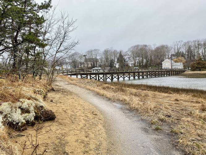
This hike technically begins at the public parking lot near Bank St and Commercial St in Wellfleet, as this is the closest public parking lot. Hikers will walk ~400-feet east along Commercial Street to reach the trailhead at Uncle Tim's Bridge.

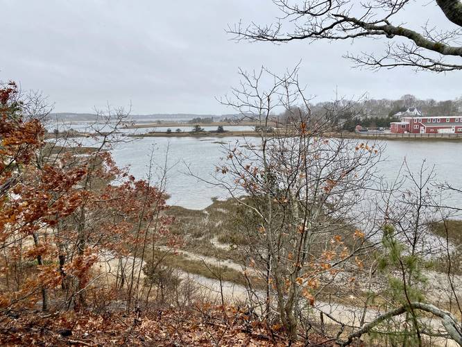
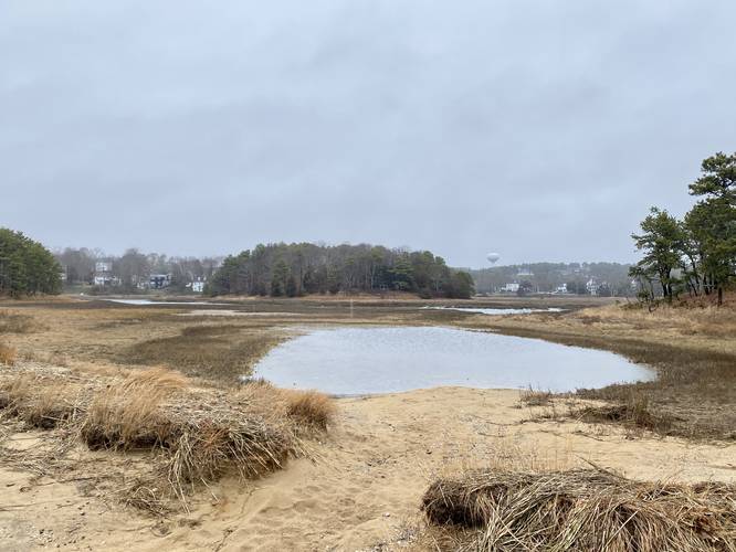
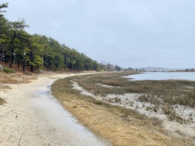
Hikers will walk across the bridge and over the saltwater river, while enjoying the views, to reach Cannon Hill. From here, you have three choices - hike left, straight, or right. This GPS track heads straight and up to the top of Cannon Hill where hikers can get a seasonal obstructed view of the surrounding area. Then the path leads out to the southern-most terminus which sits in what appears to be a private neighborhood. The track then heads back to follow the eastern side of Cannon Hill and back to Uncle Tim's Bridge. Once at the bridge, the track heads down the western path of Cannon Hill to take in more views from that part of Hamblen Park. Finally, once near the southern end of Cannon Hill, the hike heads back up the center pathway, passing the top of Cannon Hill once more, to hike out along Uncle Tim's Bridge for approximately 0.9-miles of walking.

History
Hamblen Park was Wellfleet's first public park and was donated to the town in 1931 by Arther Hopkins and Family.

Parking
Hikers will find two parking lots near the coordinates provided, of a similar size. The eastern-most lot is a private parking lot that kindly asks for donations to park. The other parking lot, located right nextdoor, is a public parking lot. Please follow all parking rules and regulations. If parking in the private lot, please donate some cash to help keep the lot open for the public.

Pets
Dogs are allow if leashed and must be cleaned up after.
Explore 39 trails near Wellfleet, MA
  1. Parking

    41.937186, -70.029596
  2. Main Trailhead

    41.937727, -70.028472
  3. Obstructed view from Cannon Hill's summit

    41.936211, -70.027711
    Obstructed view from Cannon Hill's summit
  4. View of the marshes around Hamblen Park

    41.934822, -70.026458
    View of the marshes around Hamblen Park
  5. View of Uncle Tim's Bridge

    41.937017, -70.02755
    View of Uncle Tim's Bridge
  6. View from western path of Cannon Hill

    41.936086, -70.0279
    View from western path of Cannon Hill
No community routes found. To add your own hike as a Community Route for this Trail guide, leave a Trip Report with an attached GPX file.

Hazards

Ticks - Lyme Disease More Info (CDC)
Poison Ivy/Oak

Seasons

All

Photo Albums

+ Add Photo Album

Upload your photos from the trail to help others know what to expect.

Preview of the MyHikes mobile app interface

Track, Log, and Explore Hikes with the MyHikes App

Explore Autumn Foliage

No Change
Some Color
Low Color
Moderate Color
High Color
Peak Color
Past Peak
Sept 1 Sept 8 Sept 15 Sept 22 Sept 29 Oct 6 Oct 13 Oct 20 Oct 27 Nov 3 Nov 10 Nov 17 Nov 24

Trip Reports (Reviews)

Ready to help fellow hikers? Add a trip report to share your experience and provide valuable insights for those planning their next hike. Your review makes the trail better for everyone.

Rated 5.0 out of 5 based on 1 rating.

Weather Forecast

In Wellfleet, MA

Explore Hiking Trails

You May Also Like

Colorado's Million Dollar Highway - Plan a day's drive adventure along the iconic Million Dollar Highway in Colorado. Explore the best short trails, roadside stops, waterfalls, vistas, ghost towns, and hot springs within a ~6 hour road trip.
Explore

Colorado's Million Dollar Highway

Plan a day's drive adventure along the iconic Million Dollar Highway in Colorado. Explore the best short trails, roadside stops, waterfalls, vistas, ghost towns, and hot springs within a ~6 hour road trip.

Read
Glacier's Going-to-the-Sun Road - Discover the breathtaking beauty of Glacier National Park along the iconic Going-to-the-Sun Road. From stunning roadside stops to picturesque waterfalls and vistas, this engineering marvel offers endless opportunities for exploration.
Explore

Glacier's Going-to-the-Sun Road

Discover the breathtaking beauty of Glacier National Park along the iconic Going-to-the-Sun Road. From stunning roadside stops to picturesque waterfalls and vistas, this engineering marvel offers endless opportunities for exploration.

Read
New York's Best Waterfalls - Whether you're planning a day hike, roadside stop, or a leisurely short walk, this guide provides hikers, travelers, and locals alike with 63 different locations to over 100 scenic waterfalls to help plan your next adventure!
Explore

New York's Best Waterfalls

Whether you're planning a day hike, roadside stop, or a leisurely short walk, this guide provides hikers, travelers, and locals alike with 63 different locations to over 100 scenic waterfalls to help plan your next adventure!

Read

Before you boogie...

Find our trail guides useful? Consider becoming a Supporter to unlock perks!

MyHikes is an indie platform that makes exploring public trails easier for everyone. The platform has no investors, no ads, and is owned and operated by one person, Dave Miller. Dave has personally mapped and written over 1,800 trail guides on MyHikes for the public to explore. MyHikes has helped millions outdoor enthusiasts plan their next adventure.

But it takes a lot of time 🕦, money 💰, work, and espresso shots ☕ to run MyHikes, including hiking , mapping , writing , and publishing new trails with high-quality (accurate) information... along with software engineering (coding) the platform like building new features, website and mobile app development (iOS and Android), site maintainance . and much much more.

Supporters unlock website and mobile app perks with an annual one-time payment of $25 (you renew) 😎👍. Or you can simply make a Donation of your choice. Otherwise, you can support us by telling your friends about MyHikes - both quick and free 🎉

Admin user profile picture

Dave Miller
MyHikes Founder