Loading...

Distance:
0.1 Miles / 0.2 km
Type:
Out-and-Back
Difficulty:
Easy
Time to Hike:
Features:
Surface Type:
Dirt
Town:
Keokea, Hawaii
Directions:
20.659911, -156.400571
Added:
February 15, 2023
Updated:
February 15, 2023
Please consider making a donation to the Maui Strong Fund to help the victims of Hawaii's recent wildfires.
Loading...
Loading...
0 '

Total Change
0 '

Ascent
0 '

Descent

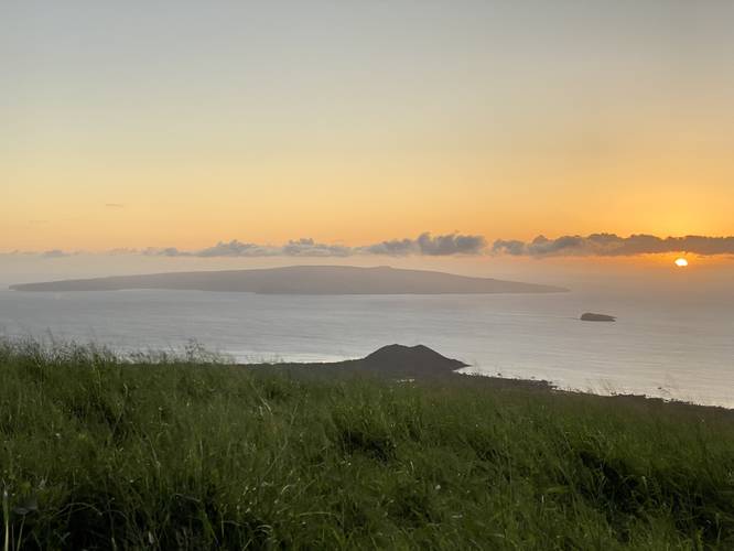
The Ulupalakua Overlook near Keokea, Hawaii (Maui) is a quick roadside stop that features a stunning views of the island of Kaho'olawe, Molokini Crater, the cinder cone Pu'u Olai, the island of Lanai, Maui's central valley, Maalaea Bay, and the west Maui mountains.

This is not a hike but rather a quick walk along this roadside stop to different vantage points. The southern and northern most part of this overlook are generally not overgrown with grass, giving the visitor better views.

Parking
There's a medium-sized parking turnout at the coordinates provided. It's large enough to fit a half-dozen cars.

Pets
Dogs are allowed if leashed and cleaned up after.

Respecting the Land
Hawaiian land is considered sacred to native Hawaiians and many locals, so please stay on-trail, take nothing but photos, and leave nothing but footprints. Respect the locals - don't stay for long and have a backup hike planned in case the parking lot is full.

Explore 58 trails near Keokea, HI
  1. Parking

    20.659911, -156.400571
  2. Main Trailhead

    20.659924, -156.400579
  3. View of Kaho'olawe, Pu'u Olai, and Molokini Crater from the Ulupalakua Overlook at sunset

    20.660194, -156.400544
    View of Kaho'olawe, Pu'u Olai, and Molokini Crater from the Ulupalakua Overlook at sunset
No community routes found. To add your own hike as a Community Route for this Trail guide, leave a Trip Report with an attached GPX file.

Seasons

All

Photo Albums

2 Trip Reports

No Star-Ratings
Write-up by:
Admin user profile picture
0.1 miles / 0.2 km
Trail added
February 15, 2023
Hiked on
February 14, 2023
Updated on
February 15, 2023
0.1 miles / 0.2 km
February 14, 2023
Hiking

Weather Forecast

In Keokea, HI

Explore Hiking Trails

New Hikes

Battery Warren Trail
1 Mile
1.6 km
Easy
Out-and-Back
Lower Ammonoosuc Falls Trail
1.1 Miles
1.8 km
Easy
Out-and-Back
Tibwin Plantation Trail
1.9 Miles
3.1 km
Easy
Out-and-Back
Larry's Creek Trail
3.6 Miles
5.8 km
Moderate
Out-and-Back

Before you leave...

MyHikes is an indie web platform aimed to make exploring public trails easier for everyone. The site has no investors and is owned and operated by one person, Dave Miller (Founder & Admin). As the Founder, main contributor, and doer-of-all-things for MyHikes, I share my trips with over-detailed write-ups for fun on a volunteer basis and I believe that public trail information should be available to everyone.

It takes a lot of time 🕦, money 💰, and effort (including espresso shots ☕) to run MyHikes, including hiking , mapping , writing , and publishing new trails with high-quality content... along with building new features, moderating, site maintainance, and app development for iOS and Android . I simply ask that if you find MyHikes' trail guides helpful to please consider becoming a Supporter to help keep the site, iOS, and Android apps available to everyone.

Supporters unlock website and in-app perks with a one-time payment of $25 (you renew) 😎👍. Or you can simply make a Donation of your choice without a MyHikes user account. Otherwise, telling your friends about MyHikes is the next-best thing - both quick and free 🎉

Thanks for visiting MyHikes and have a great hike!️

Admin user profile picture

Dave Miller
MyHikes Founder & Admin