Loading...

Distance:
2.4 Miles / 3.9 km
Type:
Loop
Difficulty:
Easy
Time to Hike:
1 hour, ~12 minutes
Features:
Surface Type:
Semi-Paved
Park:
Twin Lakes Park
Town:
Latrobe, Pennsylvania
Directions:
40.323898, -79.471507
Added:
October 15, 2018
Updated:
March 03, 2024

The Twin Lakes Park Loop Trail at Twin Lakes Park in Latrobe, Pennsylvania is an easy 2.4 mile hike that encompasses the twin lake reservoirs. The trail is mostly paved and flat with minimal ascents.

During the Fall, you can often find decent foliage around the lakes - mostly yellows and oranges, with the occasional reds.

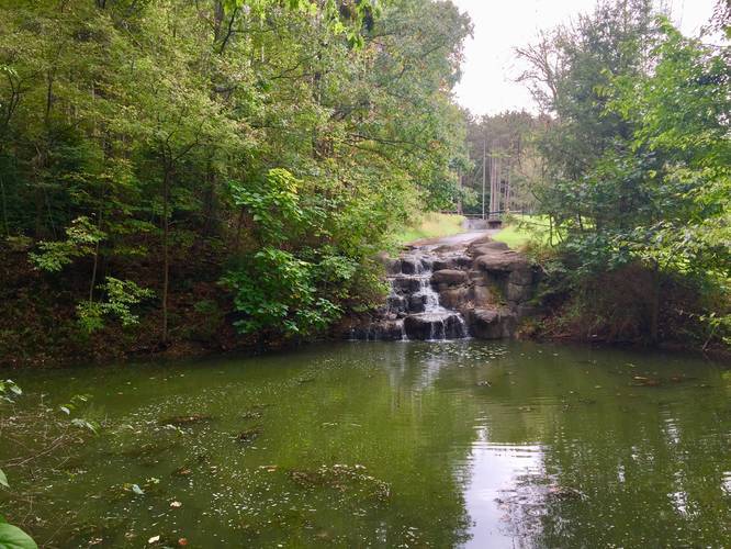
Waterfall: Along the eastern section, just south of the boardwalk is a waterfall that cascades about 10 feet to the Lower Lake below.

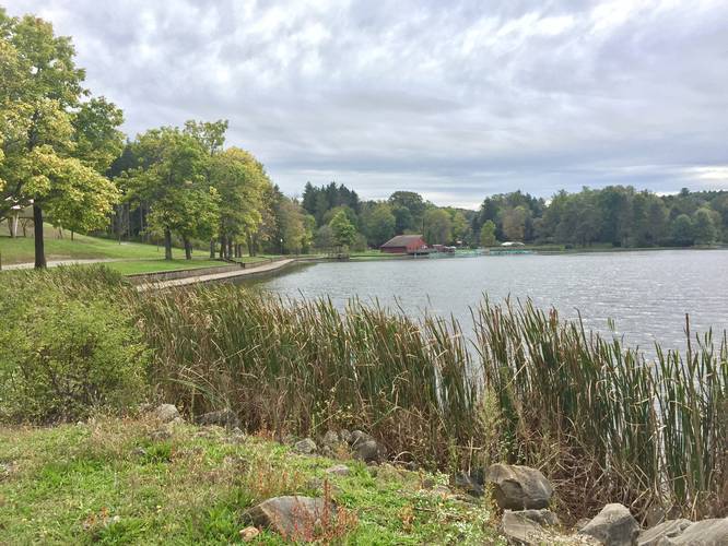
Views: Most of the views of the lakes can be found on the northeast and northern shores of the Lower Lake (northern most lake). The Upper Lake, found in the southern part of the trail has views along the dam and on the eastern shore. Following the entire trail, you'll end up hiking through the woods along most of the western half of this trail.

Dogs are allowed on this trail.

Explore 177 trails near Latrobe, PA
  1. Parking

    40.323898, -79.471507
  2. Main Trailhead

    40.324212, -79.471512
  3. View / Overlook / Vista

    40.325836, -79.473367
    View / Overlook / Vista
  4. Waterfall

    40.321214, -79.474214
    Waterfall
Explore other trail routes for this hike, added by the MyHikes Community via Trip Reports.
No community routes found. To add your own route as a Community Route for this Trail guide, please leave a Trip Report with a GPX file on this Trail.

Hazards

Ticks - Lyme Disease More Info (CDC)

Seasons

All
Loading...
Loading...
56 '

Total Change
122 '

Ascent
125 '

Descent

Photo Albums

1 Trip Report

No Star-Ratings
Write-up by:
Admin user profile picture
2.4 miles / 3.9 km
Trail added
October 15, 2018
Hiked on
October 14, 2018
Updated on
March 03, 2024

Weather Forecast

In Latrobe, PA

Explore Hiking Trails

New Hikes

Hike to Tamarack Falls
1.3 Miles
2.1 km
Easy
Out-and-Back
Spencer Pond Loop
0.3 Miles
0.5 km
Easy
Loop
Raven Rocks via Appalachian Trail
5.1 Miles
8.2 km
Strenuous
Out-and-Back
Congaree Boardwalk Loop
2.5 Miles
4 km
Easy
Loop

Before you leave...

MyHikes is an indie web platform aimed to make exploring public trails easier for everyone. The site has no investors and is owned and operated by one person, Dave Miller (Founder & Admin). As the Founder, main contributor, and doer-of-all-things for MyHikes, I share my trips with over-detailed write-ups for fun on a volunteer basis and I believe that public trail information should be available to everyone.

It takes a lot of time 🕦, money 💰, and effort (including espresso shots ☕) to run MyHikes, including hiking , mapping , writing , and publishing new trails with high-quality content... along with building new features, moderating, site maintainance, and app development for iOS and Android . I simply ask that if you find MyHikes' trail guides helpful to please consider becoming a Supporter to help keep the site, iOS, and Android apps available to everyone.

Supporters unlock website and in-app perks with a one-time payment of $25 (you renew) 😎👍. Or you can simply make a Donation of your choice without a MyHikes user account. Otherwise, telling your friends about MyHikes is the next-best thing - both quick and free 🎉

Thanks for visiting MyHikes and have a great hike!️

Admin user profile picture

Dave Miller
MyHikes Founder & Admin