The Tundra Communities Trail at Rocky Mountain National Park near Estes Park, Colorado is a moderate 1.2-mile out-and-back hike that passes through an alpine tundra landscape and features breathtaking views of the surrounding snow-capped mountains.
Hike
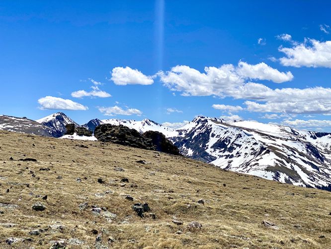
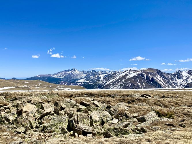
This hike begins at the main parking lot for both the Tundra Communities Trail and the Rock Cut Overlook. The trailhead is located on the same side as the parking lot, on the eastern side of Trail Ridge Road. This trail begins at the trailhead staircase, located on the north side of the parking lot, and follows the paved trail as it heads northeast through an exposed alpine tundra landscape. Along the way are stunning views of the often snow-capped rocky mountains that surround the mountain ridge and trail. For those who are interested in learning about the tundra landscape, there are interpretive signs spaced perfectly for those who have a hard time hiking or walking at this 12,000-foot altitude. The interpretive signs provide information on the tundra and tundra life, including how long it takes plants to mature in freezing temperatures -- often decades or up to a century.
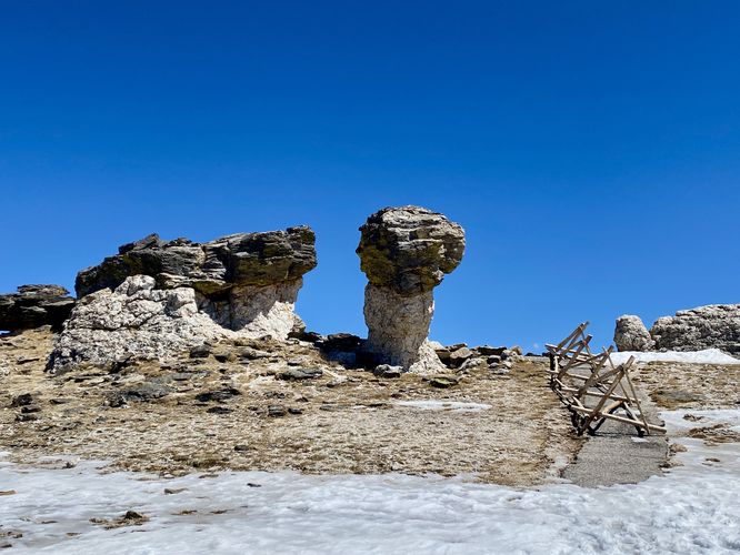
Mushroom Rocks - Mile 0.4
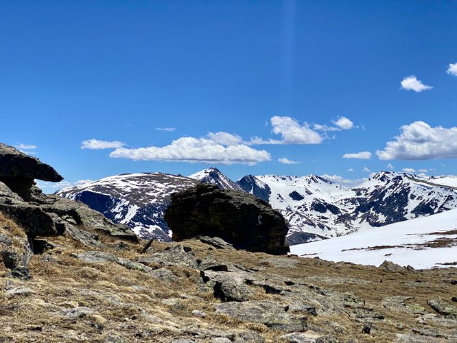
Around mile 0.4, hikers will reach a rocky outcropping that resembles the shape of a mushroom. These mushroom-shaped rocks were born of water and fire. The dark colored schist was originally sand, silt, and clay at the bottom of a sea. Magma from deep in the earth invaded the schist and gradually cooled into a lighter-colored granite. Mushroom shapes were formed when the granite stems eroded more quickly than the schist caps.
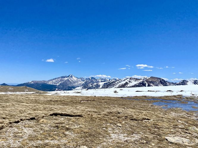
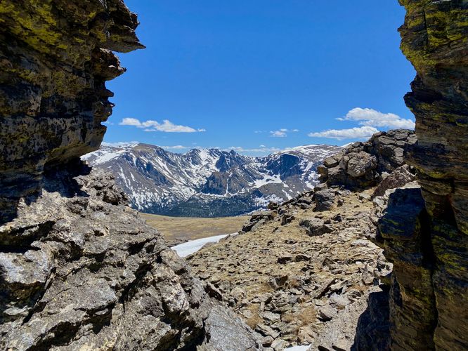
Scramble View - Mile 0.6
At the very end of the trail is another large rock outcropping that provides a beautiful view of the surrounding mountains, Trail Ridge Road, and the Ute Trail. This outcropping requires a bit of rock scrambling and provides a few different vantage points. You can choose to scramble up ~15-feet, ~5-feet, or take a precarious walk on uneven rocky terrain to a view that's cut between these eroded rocks. Regardless, the view is breathtaking, but watch out for strong winds as it can knock you around in the natural rock wind-tunnels.
The hike back to parking is easy as most of it is flat and downhill. Note that during periods of snow melt, snowfields may leave parts of the flatter section of trail very wet with slushy sections that require extra navigating -- or if you don't mind your feet getting wet, a bit of freezing socks and footwear.
Universal Access
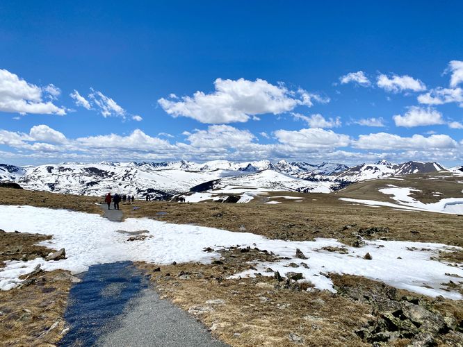
This trail is universally accessible and follows a paved pathway out to the overlook. The universally-accessible portion of the trail is located on the south side of the parking lot (i.e. where this GPS track ends). The trailhead listed in this GPS track's data follows a staircase uphill first. Please note that the grade of the trail along the universally-accessible southern trailhead is fairly steep at the beginning of the trail - I'm unsure of the trail's grade here, but it's not very flat until you reach mile 0.25.
Difficulty
Due to the steep elevation grade and the potential that visitor's have not fully acclimated to the 12,000-foot altitude, this trail should be considered 'moderate'. Some hikers will find the hike is easy, especially those who have fully acclimatized to this altitude.
Pets
Dogs are not allowed on this trail.
Parking
Hikers will find a large parking lot at the coordinates provided, located on Trail Ridge Road. The lot is large enough to fit a few dozen vehicles as of June 2024.
Wildlife Viewing
This trail can be good to view wildlife like the yellow-bellied marmot as they love the alpine tundra landscape.
Timed-Entry Reservations
Between the months of late May through early October you must purchase a timed-entry pass to visit Rocky Mountain National Park. If you wish to visitor and hike anything off of the Bear Lake Road, you must purchase a dedicated Bear Lake timed-entry pass. You can find more information about timed entry on the park's website.
Warnings
Elevation sickness: This trail brings hikers through terrain that ascends up to 12,300-feet above sea level. Around the 7,000-foot mark above sea level, hikers may start to experience symptoms of elevation sickness including headache, muscle aches, shortness of breath, among other warning signs. In order to avoid elevation sickness it's recommended to ascend to higher elevations and take short walks to acclimate over the course of several days before taking a long or physically-demanding hike. At any time you feel elevation sickness kicking in, that's the time to turn back and head for lower altitude or the parking lot.
Wild animals: While rare, hikers may encounter bears or mountain lion along the trail. Again, this is rare due to the insane amount of people who hike these trails each day; however, it's smart to know that these wild animals could be on-trail. Please read-up on how to properly handle a bear or mountain lion encounter before hitting the trails.
High exposure: This alpine trail is fully exposed with very little, if any shade along the trail. Due to the lack of shade and the combination of altitude at 11,600-feet above sea level, the UV index is significantly higher on this trail than on lower-altitude trails at the park. Sun exposure should be taken seriously and hikers should apply sunscreen or hike when the UV index is not as high. Additionally, due to the lack of trees and shrubs, the trail can be extremely windy. When we did this hike, the wind was almost constant at about 40mph or more, which pushed us around a bit.
Fragile tundra ecosystem: This trail passes through an alpine tundra, which see freezing temperatures 5 months out of the year. Due to the cold weather and harsh wind conditions, tundras see very slow growth and plants can take a very-long time to mature. Additionally, foot steps and trampling can cause plants to take decades to recover. For these reasons, please stay on-trail at all times while hiking in Rocky Mountain's alpine tundra landscapes.
Hike
This hike begins at the main parking lot for both the Tundra Communities Trail and the Rock Cut Overlook. The trailhead is located on the same side as the parking lot, on the eastern side of Trail Ridge Road. This trail begins at the trailhead staircase, located on the north side of the parking lot, and follows the paved trail as it heads northeast through an exposed alpine tundra landscape. Along the way are stunning views of the often snow-capped rocky mountains that surround the mountain ridge and trail. For those who are interested in learning about the tundra landscape, there are interpretive signs spaced perfectly for those who have a hard time hiking or walking at this 12,000-foot altitude. The interpretive signs provide information on the tundra and tundra life, including how long it takes plants to mature in freezing temperatures -- often decades or up to a century.
Mushroom Rocks - Mile 0.4
Around mile 0.4, hikers will reach a rocky outcropping that resembles the shape of a mushroom. These mushroom-shaped rocks were born of water and fire. The dark colored schist was originally sand, silt, and clay at the bottom of a sea. Magma from deep in the earth invaded the schist and gradually cooled into a lighter-colored granite. Mushroom shapes were formed when the granite stems eroded more quickly than the schist caps.
Scramble View - Mile 0.6
At the very end of the trail is another large rock outcropping that provides a beautiful view of the surrounding mountains, Trail Ridge Road, and the Ute Trail. This outcropping requires a bit of rock scrambling and provides a few different vantage points. You can choose to scramble up ~15-feet, ~5-feet, or take a precarious walk on uneven rocky terrain to a view that's cut between these eroded rocks. Regardless, the view is breathtaking, but watch out for strong winds as it can knock you around in the natural rock wind-tunnels.
The hike back to parking is easy as most of it is flat and downhill. Note that during periods of snow melt, snowfields may leave parts of the flatter section of trail very wet with slushy sections that require extra navigating -- or if you don't mind your feet getting wet, a bit of freezing socks and footwear.
Universal Access
This trail is universally accessible and follows a paved pathway out to the overlook. The universally-accessible portion of the trail is located on the south side of the parking lot (i.e. where this GPS track ends). The trailhead listed in this GPS track's data follows a staircase uphill first. Please note that the grade of the trail along the universally-accessible southern trailhead is fairly steep at the beginning of the trail - I'm unsure of the trail's grade here, but it's not very flat until you reach mile 0.25.
Difficulty
Due to the steep elevation grade and the potential that visitor's have not fully acclimated to the 12,000-foot altitude, this trail should be considered 'moderate'. Some hikers will find the hike is easy, especially those who have fully acclimatized to this altitude.
Pets
Dogs are not allowed on this trail.
Parking
Hikers will find a large parking lot at the coordinates provided, located on Trail Ridge Road. The lot is large enough to fit a few dozen vehicles as of June 2024.
Wildlife Viewing
This trail can be good to view wildlife like the yellow-bellied marmot as they love the alpine tundra landscape.
Timed-Entry Reservations
Between the months of late May through early October you must purchase a timed-entry pass to visit Rocky Mountain National Park. If you wish to visitor and hike anything off of the Bear Lake Road, you must purchase a dedicated Bear Lake timed-entry pass. You can find more information about timed entry on the park's website.
Warnings
Elevation sickness: This trail brings hikers through terrain that ascends up to 12,300-feet above sea level. Around the 7,000-foot mark above sea level, hikers may start to experience symptoms of elevation sickness including headache, muscle aches, shortness of breath, among other warning signs. In order to avoid elevation sickness it's recommended to ascend to higher elevations and take short walks to acclimate over the course of several days before taking a long or physically-demanding hike. At any time you feel elevation sickness kicking in, that's the time to turn back and head for lower altitude or the parking lot.
Wild animals: While rare, hikers may encounter bears or mountain lion along the trail. Again, this is rare due to the insane amount of people who hike these trails each day; however, it's smart to know that these wild animals could be on-trail. Please read-up on how to properly handle a bear or mountain lion encounter before hitting the trails.
High exposure: This alpine trail is fully exposed with very little, if any shade along the trail. Due to the lack of shade and the combination of altitude at 11,600-feet above sea level, the UV index is significantly higher on this trail than on lower-altitude trails at the park. Sun exposure should be taken seriously and hikers should apply sunscreen or hike when the UV index is not as high. Additionally, due to the lack of trees and shrubs, the trail can be extremely windy. When we did this hike, the wind was almost constant at about 40mph or more, which pushed us around a bit.
Fragile tundra ecosystem: This trail passes through an alpine tundra, which see freezing temperatures 5 months out of the year. Due to the cold weather and harsh wind conditions, tundras see very slow growth and plants can take a very-long time to mature. Additionally, foot steps and trampling can cause plants to take decades to recover. For these reasons, please stay on-trail at all times while hiking in Rocky Mountain's alpine tundra landscapes.