Trail names: Tumbling Waters Trail
Location: Pocono Environmental Education Center, 538 Emery Road, Dingmans Ferry, PA. Delaware Water Gap National Recreation Area.
Permitted uses: Hiking,Nature Study
Prohibited uses: Motor vehicles and bicycles are not allowed on the Trails. Swimming, Rock Climbing and jumping into the water is prohibited.
Hours: Trails are open every day from Dawn to Dusk. The Education Center is open from 8:30am to 4:30pm every day with the exception of major holidays.
Fees and Parking: There is no fee to park or use the trails at the Pocono Environmental Education Center. There is ample parking at the Center and spaces reserved for Handicap access.
Pets: Dogs are allowed on the trails as long as they are leashed and their owners clean up after them.
Accessibility: The Pocono Environmental Education Center is wheelchair accessible, but this trail was not.
Hiker amenities: There is an information kiosk in the parking area, and also on the covered porch entrance of the Pocono Environmental Education Center (PEEC) and inside the Center. Trail Guides in English and Spanish are available outside and inside the center for all trails. If you take a trail guide, a donation is not required, but is certainly appreciated. A donation of 50 cents per guide is suggested. There are restrooms available to hikers inside the Center as well as trash bins and water. Trash bins and recycling bins are stationed at the start of the Tumbling Waters Trail. The trail guide is not just a map, it's also an educational interpretive guide.
Length and Trail information: The trail was hiked as a loop, is approximately 3 miles long and was an easy hike. The Trail is marked by Orange trail blazes.
We would encourage all hikers to take along one of the PEEC’s Interpretive Trail Guides because there are 20 marked spots along the trail and they are explained in the guide. Although it’s not necessary to take a guide to enjoy the hike, the trail guide adds an additional layer of learning and appreciation. Without this guide, we may not have realized that we had been in several different types of forests during our hike. Thanks to the guide we were able to appreciate and acknowledge when we were hiking through a Pine forest, a Cedar Knoll, a Mixed Oak forest, a Hemlock Ravine, a Mixed Deciduous forest, a Pine Plantation, an Emergent Wetland and Shrub Wetland. Without the guide pointing out these ecosystems, it would have been just another walk in the woods.
Our hike began a short distance from the PEEC just off Campus Drive and to the right. The trail was well shaded and the substrate was typical of a Pine Forest. To begin, we hiked along a wide path atop a layer of pine needles that carpeted the trail, with the occasional tree roots poking up here and there. There were no real trip hazards along this section of trail.
The trail is well marked and easy to follow, not only because of the abundance of orange trail blazes, but also the educational markers that are posted to encourage hikers to stop, read and learn about the area. There also appears to be a lot of foot traffic here and that helps to mark the trail, although on this visit we did not encounter any other hikers.
We made our way along the trail, enjoying the guide and the information about each stop. At stop #3, we took out our compass and tried to figure out the direction of the glacial striations we saw in the exposed bedrock. Without the guide, we would have just walked right over this feature and not learned a thing. At our next stop, we were surprised to find out ( at Cedar Knoll, stop #4) that the trees we think of as Cedars here in the United States, are not actually cedars at all! They are junipers! The trail then narrows and descends until it reaches Brisco Mountain Road where it crosses the road and continues on the other side. Use caution when crossing.
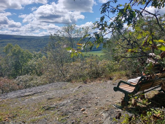
At another stop, #7, we stopped to inspect a fireplace that is the only remnant of a cabin that once stood there. There is also a tiny bit of a view at this stop, a “pocket view”, where if you're lucky, you might see birds soaring on the thermocline. This area is also a habitat for two venomous snakes, the Northern Copperhead and the Timber Rattlesnake, so use caution as you make your way along the trail. A short distance from the fireplace we found a bench with a great view of the fields below and decided this would be a good place to take a break and have a snack before moving on to the waterfalls.
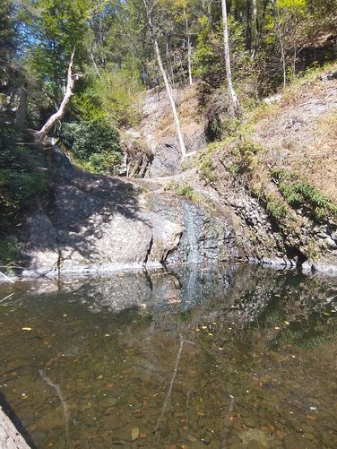
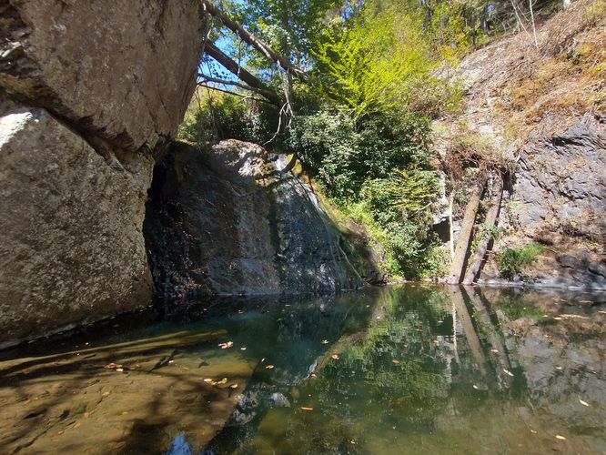
When we got to the junction of the waterfall, we made our way down the steep steps to the base of the falls. During our visit, there was not much water flowing and we were able to access sections that are undoubtedly submerged during wetter seasons. Even when the falls are just a trickle, it’s a beautiful spot to visit. The banks of the stream were covered in blooming jewel weed and cardinal flowers, much to the delight of the hummingbirds that we were able to watch during our brief visit there.
After our visit to the falls, we climbed back up the steep steps and continued through a rocky section of the trail, excited to see what the next educational stop would teach us. We made our way through the Mixed Deciduous Forest and headed toward the man made Pickerel Pond. The trail led us back over the Brisco Mountain Road and to a boardwalk that ended with a large observation blind where visitors can learn about the different birds and animals that live in and around Thoma Pond. The Pond is just behind the blind. After spending some time peeking out of the observation holes, and looking at the felted bird display, we ended our hike by heading back to the parking area.
We really enjoyed our visit to the PEEC. This non profit is doing a great job preserving the habitat for wildlife and encouraging learning and preservation of these special places. If you are lucky enough to be in this part of Pennsylvania we would heartily encourage a visit or two to this Center and their well kept trails.
Alternative hike to Tumbling Waters: If you're looking for a scenic, but shorter hike to reach the ~70-foot tall multi-tiered Tumbling Waters cascades, you can hike in from US-209. Follow our Tumbling Waters Hike guide for the shorter 0.8-mile route which leads to the lower portion of the waterfalls and technically to sections of the cascades that this trail does not lead to!