The Tumbling Waters Hike at Delaware Water Gap National Recreation Area near Pine Ridge, Pennsylvania is an easy 0.8-mile out-and-back hike that leads to the ~70-foot multi-tiered waterfall, Tumbling Waters.
Hike Description
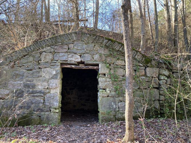
This hike begins at the medium-sized parking turnout at the coordinates provided along US-209. The trailhead, as of December 2023, had no signage, which makes this trail a bit obscure unless you know where to look. Hikers will follow the main path as it heads northwest from the parking area, passing an old stone storage "grotto" along the way -- located around mile 0.05, just a few-hundred feet into the hike.
The trail then follows the creek as it skirts its banks, providing hikers with a scenic creek side walk, as it heads northward. The trail then bends around the last corner to head westward toward Tumbling Waters. Along the way, hikers will find several small waterfalls (approx. 3-feet max) within the creek, located off-trail.
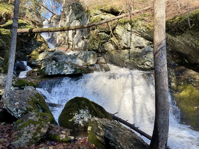
Tumbling Waters ~70-foot waterfall - Mile 0.4
Around mile 0.35, hikers will get a view of the large Tumbling Waters downstream from the trail. The best views are at the base of the waterfall, located around mile 0.4 -- at the end of this GPS track. The closer you get to the base, the worse some of the upper-tier views get, so you can poke around the banks of the creek to find a spot you like -- just be careful of the super slippery and slick rocks.
After visiting Tumbling Waters, this hike ends at mile 0.8 after hiking back to the parking lot.
Parking
Hikers will find a medium-sized parking turnout at the coordinates provided. The lot is large enough to fit about a dozen vehicles, or slightly less, as of December 2023.
Pets
Dogs are allowed if leashed and must be cleaned up after.
Warnings
Slick rocks: The best views of Tumbling Waters is from the base, around the creek's banks; however, the bank of this creek is littered with slick and slippery bedrock. Watch your step and don't get too close to the water in case you accidentally slip.
Hike Description
This hike begins at the medium-sized parking turnout at the coordinates provided along US-209. The trailhead, as of December 2023, had no signage, which makes this trail a bit obscure unless you know where to look. Hikers will follow the main path as it heads northwest from the parking area, passing an old stone storage "grotto" along the way -- located around mile 0.05, just a few-hundred feet into the hike.
The trail then follows the creek as it skirts its banks, providing hikers with a scenic creek side walk, as it heads northward. The trail then bends around the last corner to head westward toward Tumbling Waters. Along the way, hikers will find several small waterfalls (approx. 3-feet max) within the creek, located off-trail.
Tumbling Waters ~70-foot waterfall - Mile 0.4
Around mile 0.35, hikers will get a view of the large Tumbling Waters downstream from the trail. The best views are at the base of the waterfall, located around mile 0.4 -- at the end of this GPS track. The closer you get to the base, the worse some of the upper-tier views get, so you can poke around the banks of the creek to find a spot you like -- just be careful of the super slippery and slick rocks.
After visiting Tumbling Waters, this hike ends at mile 0.8 after hiking back to the parking lot.
Parking
Hikers will find a medium-sized parking turnout at the coordinates provided. The lot is large enough to fit about a dozen vehicles, or slightly less, as of December 2023.
Pets
Dogs are allowed if leashed and must be cleaned up after.
Warnings
Slick rocks: The best views of Tumbling Waters is from the base, around the creek's banks; however, the bank of this creek is littered with slick and slippery bedrock. Watch your step and don't get too close to the water in case you accidentally slip.