Loading...

❄️ WINTER SALE! 50% OFF on Supporter Accounts — now through January 31st. Unlock a full year of exclusive website & app perks. Learn More.

Trumbo Hollow Hike

A beautiful out and back hike on the Appalachian Trail passing through fields, streams, lush forest, and the Jim and Molly Denton Shelter. Trumbo Hollow is an expansive meadow with a bench at the high point. With fields and fences that make you feel like you're in a J.R.R. Tolkien novel the hike down towards VA638 is one more Kodak moment. From the valley enjoy another forest walk before arriving at the Jim and Molly Denton Shelter which boasts a picnic pavilion and gravity fed shower.
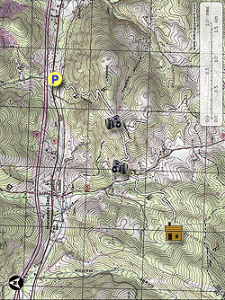
  • Mile 0.0 – From the parking area on VA55, the Appalachian Trail (AT) continues south from the left of the parking area next to a small stream. Shortly cross the headwaters of Goose Creek, then pass through a wetland area with boards protecting the fragile ecosystem. The AT will soon arrive at a railroad crossing.
  • Mile 0.15 - Use Extreme Caution crossing the railroad as this track is in use. From this point the AT becomes steeper and makes several switchbacks passing large granite formations. After cresting the high point on the piedmont the trail levels of then enters Trumbo Hollow and a large meadow. At the top of the meadow there is a bench with views to the north.
  • Mile 1.36 - Continue on the AT re-entering the woods where the trail descends following one of the ridge spurs. Halfway towards the valley the woods open to large fields with split rail fences. Continue downward and pass through a white fence onto VA638.
  • Mile 2.0 - Turn left onto VA638 for 30 yards passing a 2 car parking area, then turn right back onto the AT. This section of the trail is flatter before crossing a small stream. Now continue uphill for another 1.1 miles where this hike ends at the Jim and Molly Denton Shelter.
  • Mile 3.3 - The shelter has room for 7 people, and also includes a privy, spring, shower, and several tent camp sites. The shelter is named for Jim and Molly Denton who were active PATC members from 1960-1991. This is the turn around point. Follow the AT back to the north and VA55.
  • Mile 6.0 - Arrive back at the parking area and VA55.
Explore 66 trails near Linden, VA

Know Before You Go

  • The Trumbo Hollow hike is a 6-mile out-and-back section of the Appalachian Trail near Linden, VA, featuring diverse scenery including meadows, streams, forests, and fields.
  • The hike includes notable landmarks like Trumbo Hollow meadow with a bench and views, fields with fences reminiscent of Tolkien novels, and the Jim and Molly Denton Shelter with amenities like a shower and picnic pavilion.
  • Hikers should exercise caution at the railroad crossing at mile 0.15 and be prepared for both uphill and downhill sections, including switchbacks and a descent through fields to VA638.
Interactive topographic map for Trumbo Hollow Hike located in Linden, VA. Click the "View Map" button to load GPS coordinates and trail markers.
Get directions
Distance
6.0 mi
Difficulty
Moderate
Type
Out-and-Back
Est. Time
3 hrs
Elev. Gain
1,439'
Rating
3.7
Added
April 03, 2025
Updated
April 06, 2025

Weather Forecast

Loading...
Total Change
665'
Ascent
1,439'
Descent
1,445'
Loading...

Download the GPX Data for Offline Use

Supporters get exclusive access to download trail routes to the MyHikes app for offline use. Stay prepared on your adventure, even without an internet connection! Become a Supporter today to unlock this feature and hike with confidence.

Download Trumbo Hollow Hike GPX Data to the MyHikes Mobile App

Features

Vista / Lookout Point
Dogs
Camping
Water Source
Appalachian Trail logo Appalachian Trail hike

Points of interest

  1. Parking

    38.909236, -78.053337
  2. Main Trailhead

    38.909302, -78.053463

Safety information

For your own safety: plan ahead, let someone know where you'll be, and hike at your own risk.

Hazards

Snakes (Rattlesnakes, Copperheads, others)
Poison Ivy or Poison Oak

Markers

Blaze Color

White

Availability

All seasons

Surface type

Dirt

Trip Reports (Reviews)

Rated 3.71 out of 5 based on 7 ratings.

Ready to help fellow hikers? Add a trip report to share your experience and provide valuable insights for other hikers!

By: Dan
6.0 miles / 9.7 km
November 28, 2016
What a lovely hike! While there are no real overlooks, the views of the high meadows are really a sight to see. Because the leaves were off the trees, you could catch glimpses of some mountain peaks in the distance, and the woods portions of the hike made you feel like you were on the Great East Road near where Frodo and his companions first encountered the Black Rider! The trail through the meadows presents no difficulties, but it's a good idea to wear hiking boots on the main ascent/descent as several segments are rocky and encrusted with scree. My Fitbit measured the elevation gain at just over 1500 feet for this out and back, which is more than advertised by Hiking Upward. I will definitely do this one again in the spring when the mountain laurel is in bloom.
Legacy Review
By: Steve from Winchester
6.0 miles / 9.7 km
November 27, 2016
This was a very nice hike. The first part has a nice series of switchbacks up a ridge to a beautiful meadow with great views. There were a lot of both day and overnight hikers enjoying a beautiful day. The shelter at the end of the hike was very nice except for the group of 10 to 12 people making a lot of noise. Overall, I recommend this hike as a great way to spend 3 to 4 hours.
Legacy Review
By: Medic G
6.0 miles / 9.7 km
November 25, 2016
Ok, overall maybe a 2.5. I think it was a decent hike. I would say the difficulty rating of 3 is correct. The views are rated at a 4. I would maybe go a 3 on views. With the exception of the meadow, there isn't much in the way of views. I will say the view from the meadow was great. On solitude, I would give it maybe a 2. Definitely NOT a trail for solitude. My wife and I saw 2 groups of 3 hikers each prior to arriving at the shelter. At the shelter there were about 8 people there with 3 dogs running loose. My wife and I had our dog however, she was on a leash. Since the other dogs were running loose, it made us not stay at the shelter long at all. It would have been nice to check out the shelter more but, maybe another day. Also, this is the only hike I've done where I had to cross train tracks. Like I said, a decent hike and the meadow is nice. Just don't expect to be alone.
Legacy Review
No community routes found. To add your own hike as a Community Route for this Trail guide, leave a Trip Report with an attached GPX file.

Popular categories

Scenic mountain view representing vista trails
Vista trails
Scenic gorge of cascades representing waterfall trails
Waterfall hikes
Rugged mountain terrain representing summit trails
Summit trails
Scenic mountain view representing dog-friendly trails
Dog-friendly
Scenic campsite with a view representing camping trails
Camping trails
Appalachian Trail logo representing A.T. hikes
A.T. hikes

You May Also Like

25 Best Day Hikes in North Carolina - Discover the top 25 best day hikes in North Carolina, from breathtaking waterfalls to mountain peaks. Explore hidden gems, scenic views, and trails suitable for all skill levels, perfect for your next outdoor adventure.
Explore

25 Best Day Hikes in North Carolina

Discover the top 25 best day hikes in North Carolina, from breathtaking waterfalls to mountain peaks. Explore hidden gems, scenic views, and trails suitable for all skill levels, perfect for your next outdoor adventure.

Read
🍪 We use cookies to learn about site usage and to serve map tiles. You may block cookies manually in the browser. By continuing you agree. Learn more