Trout Pond is one of the most active geological areas in the GWNF.
Limestone eroded by ground water can cause sinkholes to enlarge or form
very quickly here. The region is a honeycomb of limestone caves and
voids, and Trout Pond
itself is an extremely large sinkhole fed by a stream. The recreation
area is also one of the most scenic in the Mid-Atlantic. Located in a
valley with Rockcliff Lake, a man-made beach, large campground, and many interconnecting hiking trails.
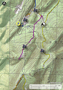
- Mile 0.0 - From the horse trailer parking area on Trout Pond Ridge the blue blazed connector trail starts at the far end. Follow the trail down through a wooded section for 0.5 miles where it ends at the while blazed Doris Agnew Lake Trail and Rockcliff Lake.
- Mile 0.5 - Turn right at the lake and onto the white blazed trail. Cross the first of two wooden foot bridges, then the trail turns to the left following the lake and arrives at the beach area and rest rooms. Turn right into the first parking area, walk to the right to the second large parking, then left into the picnic area towards Trout Pond staying to the right of the rest rooms. In 70 yards pass a split rail fence with Trout Pond directly ahead in another 25 yards.
- Mile 0.9 - Trout Pond is the largest sinkhole in the campground. The pond is only partially filled even during heavy rains, and generally empty in the summer when water drains into the caverns below. Turn right at Trout Pond and cross a park road. The trail will then arrive at the next park road and rest rooms in 60 yards. Turn right onto the park road and soon the road will split. Stay right and arrive at the Junior Poe trailhead at campsite #27.
- Mile 1.3 - Turn right uphill onto the purple blazed Junior Poe Trail. l. The Junior Poe Trail is a coarse gravel road for the first 0.1 miles. Stay straight uphill as the gravel road turns left. The trail becomes steeper and soon passes a small pump shed. Continue up the rutted trail and arrive at the Lina Constable Overlook in 0.2 miles.
- Mile 2.3 - The trail will now widen and become less steep, soon entering the first of two clearings. Pass through the first, then shortly enter the smaller second clearing. After reentering the forest on the opposite side the purple blazed trail descends for 0.1 miles where it ends at FR59.
- Mile 3.0 - Turn left uphill on the forestry road and follow it to the ridge and junction of the Laurel Run and North Mountain Trails. At this point FR59 becomes turns left and becomes FR691 as it enters Virginia. Continue along the forestry road and in 0.2 miles begin to descend then soon arrive at the yellow blazed Long Mountain Trail.
- Mile 4.8 - Turn left onto the yellow blazed Long Mountain Trail where it re-enters West Virginia and descends back towards the Trout Pond area. The trail is initially wide then in 0.6 miles turns left where a side trail leads to a clearing. At this point the trail narrows and has thick Mountain Laurel on either side. As you descend look for views of the valley and Trout Pond through the trees. The Long Mountain trail will makes several turns on its way to its low point and intersection with the purple blazed Trout Pond Trail.
- Mile 7.2 - Turn left onto the purple Trout Pond Trail and pass a campsite on the left. This section of the hike has many sink holes, and shortly pass the first of four large sinkholes. DO NOT enter the sinkholes as the roofs of the caverns below can easily cave in, and voids are hidden by fallen leaves. Be very cautious not to venture off the trail. After passing the fourth sinkhole reach the intersection with the Outlaw Path. Stay straight and the trail will make a sharp turn to the left and join a wider service road and intersection of the Chimney Rock Trail.
- Mile 7.7 - Turn right on the orange blazed Chimney Rock Trail then in 0.45 miles arrive at Chimney Rock and cross a small creek. Chimney Rock is a fin of granite 80ft high in places. After crossing the creek the trail will turn left recrossing the creek and climb towards Rockcliff Lake. From the creek continue for 0.3 miles where the trail makes a sharp right at the point it joins another service road. Continue uphill the turn back to the left and pass through a clearing and arrive a the northern tip of Rockcliff Lake and the Doris Agnew Lake Trail. Stay to the right on the white Doris Agnew Lake Trail with views of the lake following it for 0.35 back to the blue blazed parking area connector trail.
- Mile 8.9 - Turn right uphill on the blue blazed trail for 0.5 miles back to the parking area.
- Mile 9.4 - Arrive back at the parking area on Trout Pond Ridge.