Loading...

🍂 Prep for Fall! Unlock exclusive features to plan your perfect late-summer and autumn hikes — become a Supporter today. Learn more.

Tri-County Hike

Directions
Map
Pictures
Send to App
Distance:
8.2 Miles / 13.2 km
Type:
Out-and-Back
Difficulty:
Hard
Time to Hike:
4 hours, ~6 minutes
Features:
Surface Type:
Dirt
Park:
George Washington National Forest
Town:
Wardensville, West Virginia
Directions:
39.08535, -78.510878
Added:
February 17, 2025
Updated:
April 05, 2025
Guide by:
Copy Trail Link Hiking this trail? Send a friend or family member a link to this trail guide for your own safety. Hike at your own risk (disclaimer)
Loading...
Loading...
433'

Total Change
1,428'

Ascent
1,428'

Descent

Download the Trail Route for Offline Use

Supporters get exclusive access to download trail routes to the MyHikes app for offline use. Stay prepared on your adventure, even without an internet connection! Become a Supporter today to unlock this feature and hike with confidence.

Send to App

Key Takeaways

  • This 8.2-mile out-and-back hike on the Tuscarora Trail leads to Gerhard Shelter near Wardensville, WV.
  • The trail features a unique tri-county marker (Frederick/Shenandoah VA, Hardy WV) and several vista points.
  • Gerhard Shelter offers camping space and a nearby spring, making it suitable for both day hikes and backpacking trips.

Tri-County Hike

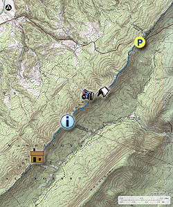
This out and back hike from US 48/55 to Gerhard Shelter passes a stone marker designating the junction of three counties in two states. Frederick Co VA, Shenandoah Co VA, and Hardy Co WV. There are also several good vistas along the hike. The view from the second campsite, views east and west from the clear-cut, and the view east from the tri-county marker. Gerhard Shelter has room around it for several tents, and a spring is located 0.25 miles down the white blazed Gerhard Shelter Trail. Besides as a day hike, this also makes for a nice weekend backpack.
  • Mile 0.0 – From the parking area on US 48/55 pass around the closed forestry gate on the blue blazed Tuscarora Trail, then shortly pass an informational kiosk and bench. The first section of trail is moss covered during the summer months and follows and old forestry road. The Tuscarora Trail from US 48/55 to Gerhard Shelter straddles the VA/WV border the entire way.
  • Mile 0.5 - Pass a campsite at a small clearing on the left. The campsite is overgrown during the warmer months, but clear and suitable for multiple tents otherwise. From this point the Tuscarora Trail will become steeper and has limited views through the trees as it continues along the ridge. This is the steepest section of the hike. Pass over the first knob and through a small saddle continuing along the ridge.
  • Mile 1.8 - Pass a campsite on the left with nice views through the gap. Again this campsite can be more overgrown in the warmer months, but is clear and has room for multiple tents late Fall through early Spring. In another 100 yards pass through a utility clear cut with panoramic views to the east and west. After the clear-cut the blue blazed Tuscarora Trail becomes more narrow. Continue along the ridge as the Tuscarora trail passes over two more rises then look for a small side trail on the left.
  • Mile 2.9 - Take the side trail on the left to an overlook to the east where a stone marker is located. The marker designates where three counties and two states meet. Frederick Co VA, Shenandoah Co VA, and Hardy Co WV. For the next 1.4 miles the trail passes over four more knolls before arriving at Gerhard Shelter.
  • Mile 4.3 - Gerhard Shelter has a large fire ring, and enough space surrounding it for several tents. There is a spring located 0.25 miles downhill on the white blazed Gerhard Shelter Trail. Gerhard Shelter is the turn around point for the hike. Retrace your route back to the north.
  • Mile 8.2 - Arrive back at US 48/55 and parking area.
Explore 67 trails near Wardensville, WV
  1. Parking

    39.08535, -78.510878
  2. Main Trailhead

    39.08535, -78.510878
No community routes found. To add your own hike as a Community Route for this Trail guide, leave a Trip Report with an attached GPX file.

Hazards

Ticks - Lyme Disease More Info (CDC)
Snakes
Poison Ivy/Oak

Seasons

All

Blaze Color

Blue

Photo Albums

+ Add Photo Album

Upload your photos from the trail to help others know what to expect.

Trip Reports (Reviews)

Rated 4.0 out of 5 based on 1 rating.
By: Steve
8.2 miles / 13.2 km
September 21, 2019
I enjoyed this hike. The trail is well maintained. I could see where grass had been cut in spots including at the campsite at mile 1.8. The shelter is a nice spot to sit for a while. The half of the trail closest to parking is remarkably smooth. It's rocky but filled in with dirt and grass. The half of the trail closest to the shelter turns rockier more toward what I am accustomed to elsewhere on the Tuscarora Trail but it's not bad. I heard several gunshorts from down in the valley to the east reminding me that hunting is permitted in national forests and I should check hunting seasons and maybe wear a bright color during those seasons when I go to the forest again. Great vistas to the east at the mile 1.8 campsite and at some rock outcroppings near mile 2.9 but otherwise the views were mostly obscured by leaves. That's fine with me but if better views are important to you winter may be a better time for this hike. I tried but failed to find the tri-county marker at mile 2.9. The description reads "Take the side trail on the left to an overlook to the east where a stone marker is located." I didn't see a side trail. The blue-blazed Tuscarora Trail veered left and soon after there was a prominent rock outcropping, about 20 x 20 feet on the left at a high point. I looked all around but didn't see the marker. (I did see a geocache box under the outcropping.) I looked at my phone map and I was at or near the intersection of county lines. I looked at the photos on the hike description. I looked further up and down a bit further on the ridge, and nothing. One of the GPX file waypoints is for the marker, but using my phone's GPS app to get to that point led me a bit further away (I think too far) into some unpromissing brush I didn't want to tackle. It is very possible I either misinterpreted the directions or the marker was there and I overlooked it. If you find the marker and leave a review please give me a little more guidance and I may try to check it out again.
Legacy Review

Weather Forecast

In Wardensville, WV

Explore Hiking Trails

You May Also Like

Colorado's Million Dollar Highway - Plan a day's drive adventure along the iconic Million Dollar Highway in Colorado. Explore the best short trails, roadside stops, waterfalls, vistas, ghost towns, and hot springs within a ~6 hour road trip.
Explore

Colorado's Million Dollar Highway

Plan a day's drive adventure along the iconic Million Dollar Highway in Colorado. Explore the best short trails, roadside stops, waterfalls, vistas, ghost towns, and hot springs within a ~6 hour road trip.

Read
New York's Best Waterfalls - Whether you're planning a day hike, roadside stop, or a leisurely short walk, this guide provides hikers, travelers, and locals alike with 63 different locations to over 100 scenic waterfalls to help plan your next adventure!
Explore

New York's Best Waterfalls

Whether you're planning a day hike, roadside stop, or a leisurely short walk, this guide provides hikers, travelers, and locals alike with 63 different locations to over 100 scenic waterfalls to help plan your next adventure!

Read

Before you boogie...

Find our trail guides useful? Consider becoming a Supporter to unlock perks!

MyHikes is an indie platform that makes exploring public trails easier for everyone. The platform has no investors, no ads, and is owned and operated by one person, Dave Miller. Dave has personally mapped and written over 1,800 trail guides on MyHikes for the public to explore. MyHikes has helped millions outdoor enthusiasts plan their next adventure.

But it takes a lot of time 🕦, money 💰, work, and espresso shots ☕ to run MyHikes, including hiking , mapping , writing , and publishing new trails with high-quality (accurate) information... along with software engineering (coding) the platform like building new features, website and mobile app development (iOS and Android), site maintainance . and much much more.

Supporters unlock website and mobile app perks with an annual one-time payment of $25 (you renew) 😎👍. Or you can simply make a Donation of your choice. Otherwise, you can support us by telling your friends about MyHikes - both quick and free 🎉

Admin user profile picture

Dave Miller
MyHikes Founder