This challenging loop in the southern district of Shenandoah National Park isn’t as well-known as some of its neighboring hikes, but it offers a wonderful variety of scenery. There are two magnificent viewpoints, a beautiful mountain stream to explore, fascinating rock formations, and solitude on some of the park’s less traveled trails. The loop makes a great day-hike, but it’s also an excellent one-night backpacking trip with camping options at two different locations. We suggest hiking the loop counter-clockwise, starting at Blackrock Gap.
Note: Avoid starting the hike in the valley at the Paine Run Trail trailhead on VA340. This area is used as a school bus turn around and should not be used for parking.
-
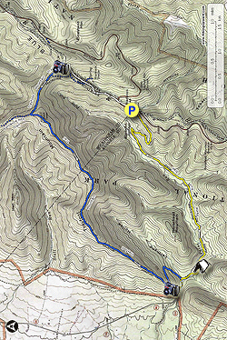
Mile - 0.0 - Park at Blackrock Gap on the western side of Skyline Drive. Immediately cross the drive and pick up the AT headed north. The trail is blazed white and will track parallel to the drive, ascending gently for .2 miles.
- Mile - 0.2 - Cross Skyline again. Remain headed northbound on the AT, ascending for about half a mile.
-
Mile - 0.7 - Reach the junction (trayfootpaine_4.jpg) of the AT and a spur trail to Black Rock Hut.
If you choose to explore the hut it will add .4 miles to the total
hike distance. This is one of the two camping options along the loop.
The site consists of a shelter with a fire pit, several tent sites, a
privy, and a spring-fed water source. If you skip the hut, continue ascending north on the AT.
-
Mile - 1.2 - Reach the junction
of the AT, the Trayfoot Mountain Trail, and the Blackrock Trail.
Continue straight on AT headed toward Blackrock Summit. Note: Do
not take this first turn onto the Trayfoot Mountain trail, or you will
miss the best view on the loop. There will be another spur leading to
the Trayfoot Mountain trail just ahead.
-
Mile - 1.25 Reach Blackrock summit and the junction of the Blackrock Spur Trail down to the Trayfoot Mountain Trail. Explore the amazing view and the rock pile at the summit, then descend via the blue-blazed Blackrock Spur. There are more great views and fun boulder jumbles along the spur trail.
-
Mile - 1.45 - Reach the junction
of the Blackrock Spur and the Trayfoot Mountain Trail. Take a right,
continuing on the blue-blazed Trayfoot Mountain Trail. The trail will
climb steadily uphill following what appears to be an old road bed.
-
Mile - 1.95 - Reach the junction
of the Trayfoot Mountain Trail and the Furnace Mountain Trail. The
Furnace Mountain Trail bears to the right. You will continue uphill,
remaining on the Trayfoot Mountain Trail in the direction of Paine Run.
This is a short but steep climb.
-
Mile - 2.15 - Reach the viewless summit of Trayfoot Mountain. Follow the rolling terrain along the ridge. You'll get nice views of Skyline Drive
to the left and tree-obstructed glimpses of Furnace Mountain to the
right. There will be some off-trail viewpoints along this ridge, but
they are largely obstructed. The best viewpoint from Trayfoot Mountain
lies several miles ahead. This section of trail has typically been
lightly maintained. You may encounter blowdowns and overgrowth.
-
Mile - 4.3 - The trail descends steadily via a couple switchbacks. Look for double blue blazes marking the bends. The trail passes some interesting cliffs and boulder jumbles here.
-
Mile - 5.25 – Reach the viewpoint of pointy, rugged Buzzard Rock and the valley below. The trail veers to the left and heads downhill.
-
Mile - 5.8 - Reach junction of Trayfoot Mountain Trail and Paine Run Trail. Turn left on yellow blazed Paine Run trail. Cross a small stream in a couple hundred feet. This stream may be seasonally dry.
-
Mile - 6.0 - Cross Paine Run. This
crossing is wide and depending on the time of year, it may be easier to
ford it than to try and rock hop across. About 50 feet after crossing
there is a great campsite
with space for several tents. If you camp here, remember that
campfires in this part of Shenandoah are illegal. If you see a fire
pit, don’t use it!
-
Mile - 6.3 Pass a beautiful series of small waterfalls and swimming holes. As you hike along the wide, yellow-blazed Paine Run Trail , you’ll ascend gently and move away from the stream. The trail will continue to cross many small feeder streams over the next two miles. Many may be seasonally dry. During wetter times, the trail may be muddy in spots
-
Mile - 8.3 – The trail takes a wide turn to the right and heads more steeply uphill. The last mile is a steady uphill.
- Mile - 9.2 - Return to vehicle at Blackrock Gap.