Loading...

🎉 Enjoy a Free 7-Day Supporter Trial and Unlock Exclusive Perks — No Credit Card Required. Learn more.

Townsite Trail (Waterton Park)

Directions
Map
Pictures
Send to App
Distance:
1.3 km / 0.8 Miles
Type:
Out-and-Back
Difficulty:
Easy
Time to Hike:
~24 minutes
Features:
Surface Type:
Dirt
Town:
Waterton Park, Alberta - Canada
Directions:
49.044921, -113.91417
Added:
September 18, 2024
Updated:
September 29, 2024
Copy Trail Link Hiking this trail? Send a friend or family member a link to this trail guide for your own safety. Hike at your own risk (disclaimer)
Loading...
Loading...
3m

Total Change
5m

Ascent
5m

Descent

Download the Trail Route for Offline Use

Supporters get exclusive access to download trail routes to the MyHikes app for offline use. Stay prepared on your adventure, even without an internet connection! Become a Supporter today to unlock this feature and hike with confidence.

Send to App

Townsite Trail (Waterton Park)

The Townsite Trail in Waterton Park, Alberta is an easy 1.3 km out-and-back trail that features breathtaking views of the Canadian Rocky Mountains that tower over Upper Waterton Lake.

Exploring the Townsite Trail

This small section of the Townsite Trail will bring visitors to the most scenic part of the trail with views that peer into Glacier National Park however, the entire length of the trail (technically a loop) encompasses the town of Waterton Park and is significantly longer than the route provided.

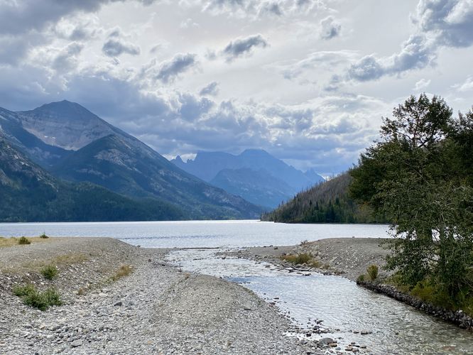
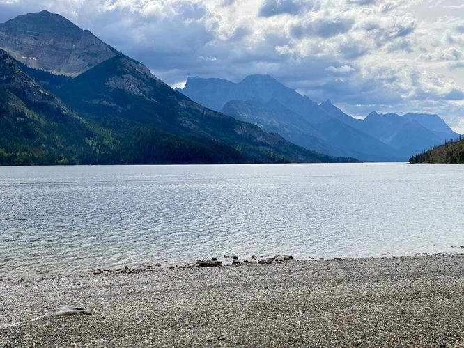
The trailhead begins at the very end of Evergreen Ave in Waterton Park where visitors will find a trailhead located just north from the parking lot. You can instead choose to walk through the grass, skipping the defined path, to make your way over to a footbridge that spans Cameron Creek. From the footbridge, the views begin as you'll peer southward directly into the United States and into the northern reaches of Glacier National Park, which sits right on the border of the two countries.

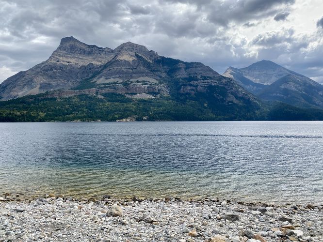
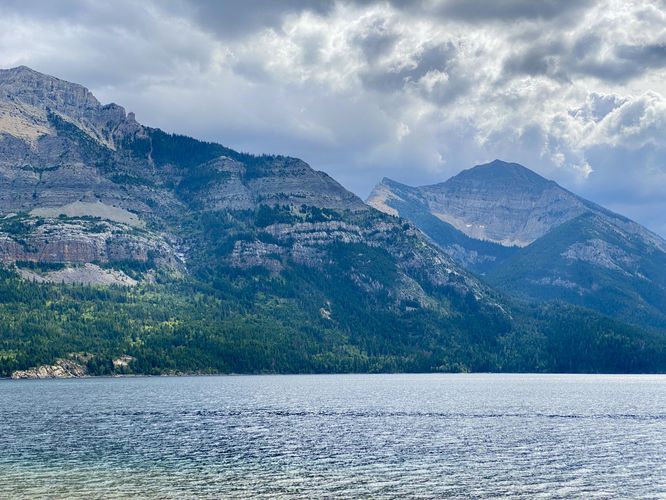
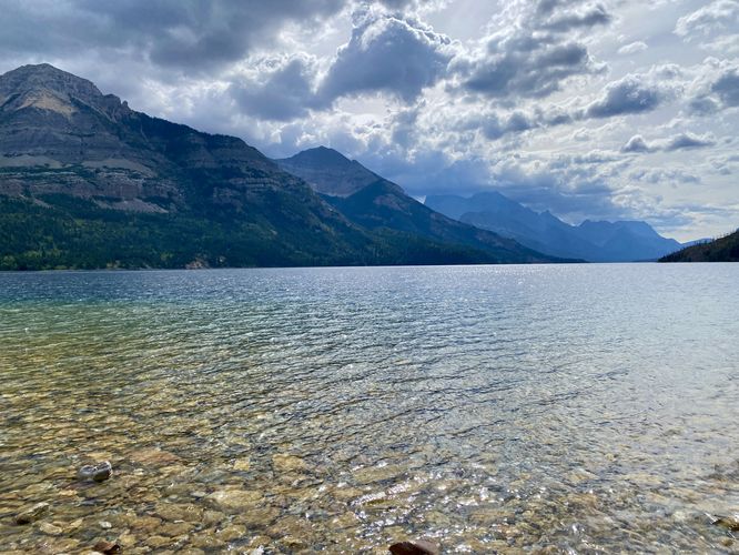
The trail then leads along the south shore of Waterton Park's waterfront and provides stunning views the entire way as it wraps around to head north toward the center of town. Along the way, visitors will find picnic tables, Adirondack-style chairs, and other amenities to make your visit along this lake shore pleasant. The views from the trail peer southward with towering mountains on either side of Upper Waterton Lake which feel like they go on forever. We only followed the trail for as far as we needed to -- approximately 0.7 km from the trailhead, to reach a part of the shore where we found colorful rocks in the water and thus skipped the flattest stones we could find. After exploring the lake shore and the views for a while, we decided to walk back to parking for a short and easy 1.3 km out-and-back walk.

Parking

Visitors will find a large parking lot at the end of Evergreen Ave in Waterton Park, Alberta. The lot is large enough to fit over several dozen vehicles as of September 2024.

Pets

Dogs are allowed only if leashed and must be cleaned up after.
Explore 35 trails near Waterton Park, AB
  1. Parking

    49.044921, -113.91417
  2. Main Trailhead

    49.045166, -113.91442
  3. View of Upper Waterton Lake from the footbridge

    49.045486, -113.913453
    View of Upper Waterton Lake from the footbridge
  4. View of Vimy Peak and Upper Waterton Lake

    49.044803, -113.912711
    View of Vimy Peak and Upper Waterton Lake
  5. View of Vimy Peak (left) and Mount Boswell (right)

    49.045436, -113.911789
    View of Vimy Peak (left) and Mount Boswell (right)
  6. View of Upper Waterton Lake from the trail

    49.046792, -113.909394
    View of Upper Waterton Lake from the trail
  7. View of Upper Waterton Lake and the Rocky Mountains of Canada and the US

    49.047256, -113.908119
    View of Upper Waterton Lake and the Rocky Mountains of Canada and the US
No community routes found. To add your own hike as a Community Route for this Trail guide, leave a Trip Report with an attached GPX file.

Seasons

All

Trip Reports

Trail Guide By:
Admin user profile picture
0.8 miles / 1.3 km
0.8 miles / 1.3 km
September 18, 2024
Easy walk with breathtaking views
Hiking

Weather Forecast

In Waterton Park, AB

Explore Hiking Trails

You May Also Like

Colorado's Million Dollar Highway - Plan a day's drive adventure along the iconic Million Dollar Highway in Colorado. Explore the best short trails, roadside stops, waterfalls, vistas, ghost towns, and hot springs within a ~6 hour road trip.
Explore

Colorado's Million Dollar Highway

Plan a day's drive adventure along the iconic Million Dollar Highway in Colorado. Explore the best short trails, roadside stops, waterfalls, vistas, ghost towns, and hot springs within a ~6 hour road trip.

Read
Glacier's Going-to-the-Sun Road - Discover the breathtaking beauty of Glacier National Park along the iconic Going-to-the-Sun Road. From stunning roadside stops to picturesque waterfalls and vistas, this engineering marvel offers endless opportunities for exploration.
Explore

Glacier's Going-to-the-Sun Road

Discover the breathtaking beauty of Glacier National Park along the iconic Going-to-the-Sun Road. From stunning roadside stops to picturesque waterfalls and vistas, this engineering marvel offers endless opportunities for exploration.

Read
New York's Best Waterfalls - Whether you're planning a day hike, roadside stop, or a leisurely short walk, this guide provides hikers, travelers, and locals alike with 63 different locations to over 100 scenic waterfalls to help plan your next adventure!
Explore

New York's Best Waterfalls

Whether you're planning a day hike, roadside stop, or a leisurely short walk, this guide provides hikers, travelers, and locals alike with 63 different locations to over 100 scenic waterfalls to help plan your next adventure!

Read

Before you boogie...

Find our trail guides useful? Consider becoming a Supporter to unlock perks!

MyHikes is an indie platform that makes exploring public trails easier for everyone. The platform has no investors, no ads, and is owned and operated by one person, Dave Miller. Dave has personally mapped and written over 1,800 trail guides on MyHikes for the public to explore. MyHikes has helped millions outdoor enthusiasts plan their next adventure.

But it takes a lot of time 🕦, money 💰, work, and espresso shots ☕ to run MyHikes, including hiking , mapping , writing , and publishing new trails with high-quality (accurate) information... along with software engineering (coding) the platform like building new features, website and mobile app development (iOS and Android), site maintainance . and much much more.

Supporters unlock website and mobile app perks with an annual one-time payment of $25 (you renew) 😎👍. Or you can simply make a Donation of your choice. Otherwise, you can support us by telling your friends about MyHikes - both quick and free 🎉

Admin user profile picture

Dave Miller
MyHikes Founder