Loading...

Distance:
0 Miles / 0 km
Type:
One-Way
Difficulty:
Easy
Time to Hike:
~5 minutes
Features:
Surface Type:
Universal Access
Town:
Tioga, Pennsylvania
Directions:
41.91381, -77.02687
Added:
November 26, 2023
Updated:
January 05, 2024
Loading...
Loading...
0 '

Total Change
0 '

Ascent
0 '

Descent

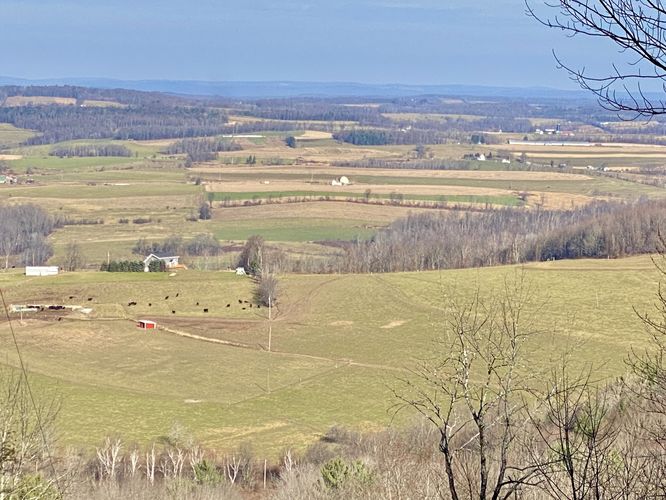
Tower Hill Vista near Tioga, Pennsylvania is a roadside view of farms down in Jackson Summit valley as viewed from Tower Hill Road.

This is simply a roadside view where drivers can pull-up to a tiny parking turnout on the North side of Tower Hill Road to find a nice view of the farms down in Jackson Summit valley.

Private Property
The land off of the road is private, please stay out. The best view is from the road anyway, so no need to leave your vehicle unless you want to get a different vantage point.

Universally Accessible
Please note that while there is no universal access pathway, due to this being a roadside drive-up vista, it should be considered universally accessible for all to enjoy.

Parking
There's a very tiny parking turnout on the North side of Tower Hill Road, at the coordinates provided. Look for the power lines that run down the mountain -- this is your public road turnout.

Explore 218 trails near Tioga, PA
  1. Parking

    41.91381, -77.02687
  2. Main Trailhead

    41.913822, -77.026891
  3. Tower Hill Vista

    41.913826, -77.026917
    Tower Hill Vista
No community routes found. To add your own hike as a Community Route for this Trail guide, leave a Trip Report with an attached GPX file.

Hazards

Ticks - Lyme Disease More Info (CDC)

Seasons

All

Photo Albums

2 Trip Reports

No Star-Ratings
Write-up by:
Admin user profile picture
0 miles / 0 km
Trail added
November 26, 2023
Hiked on
November 26, 2023
Updated on
January 05, 2024
0 miles / 0 km
November 26, 2023
Dogs Hiking

Weather Forecast

In Tioga, PA

Explore Hiking Trails

New Hikes

Larry's Creek Trail
3.6 Miles
5.8 km
Moderate
Out-and-Back
Lower Ammonoosuc Falls Trail
1.1 Miles
1.8 km
Easy
Out-and-Back
Cold Run Waterfalls & Vista Loop
3.1 Miles
5 km
Moderate
Loop
Cottonwood Falls Loop
1.2 Miles
1.9 km
Moderate
Loop

Before you leave...

MyHikes is an indie web platform aimed to make exploring public trails easier for everyone. The site has no investors and is owned and operated by one person, Dave Miller (Founder & Admin). As the Founder, main contributor, and doer-of-all-things for MyHikes, I share my trips with over-detailed write-ups for fun on a volunteer basis and I believe that public trail information should be available to everyone.

It takes a lot of time 🕦, money 💰, and effort (including espresso shots ☕) to run MyHikes, including hiking , mapping , writing , and publishing new trails with high-quality content... along with building new features, moderating, site maintainance, and app development for iOS and Android . I simply ask that if you find MyHikes' trail guides helpful to please consider becoming a Supporter to help keep the site, iOS, and Android apps available to everyone.

Supporters unlock website and in-app perks with a one-time payment of $25 (you renew) 😎👍. Or you can simply make a Donation of your choice without a MyHikes user account. Otherwise, telling your friends about MyHikes is the next-best thing - both quick and free 🎉

Thanks for visiting MyHikes and have a great hike!️

Admin user profile picture

Dave Miller
MyHikes Founder & Admin