Loading...

๐ŸŽ‰ Enjoy a Free 7-Day Supporter Trial and Unlock Exclusive Perks โ€” No Credit Card Required. Learn more.

Tompkin Falls

Directions
Map
Pictures
Send to App
Distance:
0 Miles / 0 km
Type:
Out-and-Back
Difficulty:
Moderate
Time to Hike:
~5 minutes
Features:
Surface Type:
Dirt
Park:
Catskill Park
Town:
Andes, New York
Directions:
42.075546, -74.764498
Added:
September 11, 2023
Updated:
April 05, 2025
Copy Trail Link Hiking this trail? Send a friend or family member a link to this trail guide for your own safety. Hike at your own risk (disclaimer)
Loading...

Download the Trail Route for Offline Use

Supporters get exclusive access to download trail routes to the MyHikes app for offline use. Stay prepared on your adventure, even without an internet connection! Become a Supporter today to unlock this feature and hike with confidence.

Send to App

Tompkin Falls

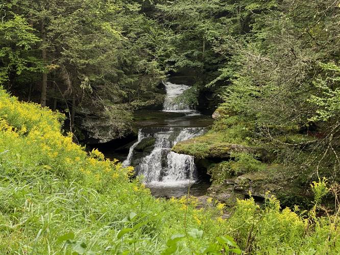
Tompkin Falls at Catskill Park near Andes, New York is a moderate 0.1-mile out-and-back hike that leads to the ~22-foot tall multi-tiered waterfall known as Tompkin Falls.

Hike Description
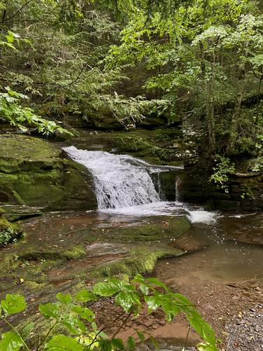
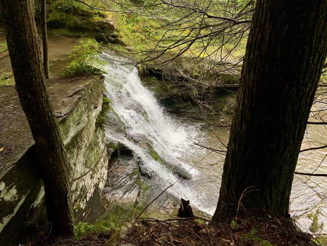
This hike begins along the southern side Barkaboom Road at the coordinates provided and heads down over the guardrail to find a steep dirt trail on the other side. The trail is very worn with minimal large rocks for footing as you descend this steep grade, so watch your balance and where you step. At the bottom of the trail, hikers will find Tompkin Falls which can be explored in two sections - upper and lower falls. The Upper Falls cascade is about 7-feet tall, which can be easily viewed without danger or risk. The Lower Falls portion of Tompkin Falls, however, can only be viewed from a very skinny and sketchy trail that skirts around the ledge adjacent to the waterfall. Hikers can follow this short path for as long as they wish - I followed it to get a photo of the side of Lower Falls and then turned back.

The hike back up to the road is not easy due to the steep grade, hence the moderate difficulty. Last, hikers can get a view of the waterfall from the road, located downstream, but watch the local traffic as this road is not very wide and has no turnouts.

Parking
Hikers will find parking along Barkaboom Road near the coordinates provided.

Pets
Dogs are allowed if leashed and should be cleaned up after.

Warning
Steep ledges: This hike includes steep ledges, so hikers should be mindful of where they walk.
Explore 6 trails near Andes, NY
  1. Parking

    42.075546, -74.764498
  2. Main Trailhead

    42.075579, -74.764546
  3. Upper Tompkin Falls

    42.075549, -74.764671
    Upper Tompkin Falls
  4. Tompkin Falls

    42.075639, -74.764693
    Tompkin Falls
  5. View of Tompkin Falls (from road)

    42.076003, -74.764878
    View of Tompkin Falls (from road)
No community routes found. To add your own hike as a Community Route for this Trail guide, leave a Trip Report with an attached GPX file.

Hazards

Ticks - Lyme Disease More Info (CDC)
Poison Ivy/Oak
Rockfalls / Ledges / or Scrambles

Seasons

All

Weather Forecast

In Andes, NY

Explore Hiking Trails

You May Also Like

Colorado's Million Dollar Highway - Plan a day's drive adventure along the iconic Million Dollar Highway in Colorado. Explore the best short trails, roadside stops, waterfalls, vistas, ghost towns, and hot springs within a ~6 hour road trip.
Explore

Colorado's Million Dollar Highway

Plan a day's drive adventure along the iconic Million Dollar Highway in Colorado. Explore the best short trails, roadside stops, waterfalls, vistas, ghost towns, and hot springs within a ~6 hour road trip.

Read
Glacier's Going-to-the-Sun Road - Discover the breathtaking beauty of Glacier National Park along the iconic Going-to-the-Sun Road. From stunning roadside stops to picturesque waterfalls and vistas, this engineering marvel offers endless opportunities for exploration.
Explore

Glacier's Going-to-the-Sun Road

Discover the breathtaking beauty of Glacier National Park along the iconic Going-to-the-Sun Road. From stunning roadside stops to picturesque waterfalls and vistas, this engineering marvel offers endless opportunities for exploration.

Read
New York's Best Waterfalls - Whether you're planning a day hike, roadside stop, or a leisurely short walk, this guide provides hikers, travelers, and locals alike with 63 different locations to over 100 scenic waterfalls to help plan your next adventure!
Explore

New York's Best Waterfalls

Whether you're planning a day hike, roadside stop, or a leisurely short walk, this guide provides hikers, travelers, and locals alike with 63 different locations to over 100 scenic waterfalls to help plan your next adventure!

Read

Before you boogie...

Find our trail guides useful? Consider becoming a Supporter to unlock perks!

MyHikes is an indie platform that makes exploring public trails easier for everyone. The platform has no investors, no ads, and is owned and operated by one person, Dave Miller. Dave has personally mapped and written over 1,800 trail guides on MyHikes for the public to explore. MyHikes has helped millions outdoor enthusiasts plan their next adventure.

But it takes a lot of time ๐Ÿ•ฆ, money ๐Ÿ’ฐ, work, and espresso shots โ˜• to run MyHikes, including hiking , mapping , writing , and publishing new trails with high-quality (accurate) information... along with software engineering (coding) the platform like building new features, website and mobile app development (iOS and Android), site maintainance . and much much more.

Supporters unlock website and mobile app perks with an annual one-time payment of $25 (you renew) ๐Ÿ˜Ž๐Ÿ‘. Or you can simply make a Donation of your choice. Otherwise, you can support us by telling your friends about MyHikes - both quick and free ๐ŸŽ‰

Admin user profile picture

Dave Miller
MyHikes Founder