Tinker Falls at Labrador Hollow Unique Area near Tully, New York is a moderate 0.6-mile out-and-back hike that leads to the 40-foot tall free-falling waterfall known as Tinker Falls.
Universal Access
Note that this trail is mostly universally-accessible from the parking lot to the Tinker Falls viewing area around mile 0.25. The trail is mostly-flat, wide, and follows a gravel and dirt path. During some parts of the year, the trail may not be fully universally accessible due to muddy areas. Reaching the best views of Tinker Falls from up-close does not follow an accessible path.
Hike Description
This hike begins along the eastern side State Route 91 along a mostly-flat gravel trail that heads into a mountain hollow following the western side of a nearby brook. The trail is mostly-flat but gains elevation slowly as you make your way up the hollow toward Tinker Falls.
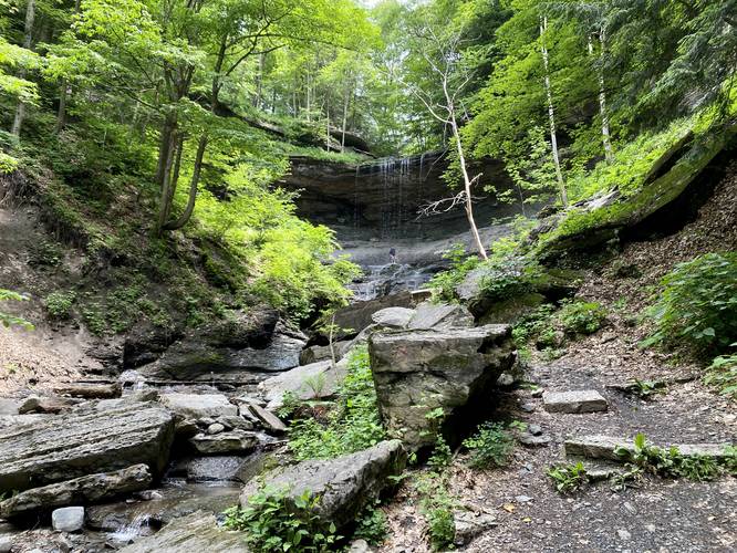
Downstream View of Tinker Falls - Mile 0.25
Around mile 0.25, hikers will reach the "end" of the maintained trail where you'll find a bench and viewing area of Tinker Falls from several-hundred feet downstream. For folks who have no desire to cross the shale bedrock, which is often slippery and wet, this is where you'll end your adventure.
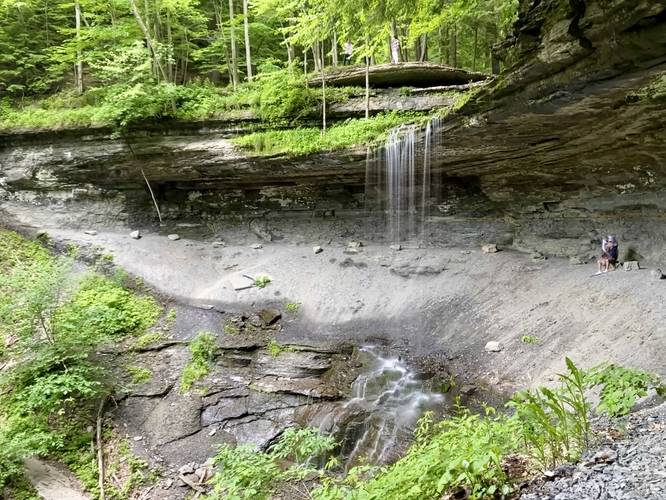
Tinker Falls - Mile 0.3
If the hiker wishes, they can carefully cross the brook at mile 0.25 to reach better views of Tinker Falls. After crossing the brook, hikers will find a stone staircase that leads up the steep rocky embankment of the hollow that Tinker Falls cascades into, to get a better view up-close of the waterfall. Here, the hike ends at mile 0.3, just to the side of Tinker Falls and features a safe view from the rock stairs. If you wish, hikers can continue under the rocky ledge to walk behind Tinker Falls; however, due to the dangers involved it may not be worth the risk.
Difficulty
If hiking to the viewing area, this should be considered an "easy" hike. Otherwise, if hiking up to Tinker Falls, it's certainly more "moderate" despite the elevation gain and mileage.
Parking
Hikers will find a large parking lot at the coordinates provided along the western side State Route 91. The parking lot is located just up the street from the trailhead. The lot is large enough to fit a couple dozen vehicles and can fill up quickly on weekends.
Pets
Dogs are allowed only if leashed and must be cleaned up after.
Warning
Brook crossing: Hikers will have to cross slippery shale bedrock in order to reach the best views of Tinker Falls.
Steep hillside: Once on the staircase that leads up to Tinker Falls, the sloping hill becomes very steep and the stone stairs are very skinny. These stairs, when wet, can be very slick which could send the hiker tumbling down the hill.
Universal Access
Note that this trail is mostly universally-accessible from the parking lot to the Tinker Falls viewing area around mile 0.25. The trail is mostly-flat, wide, and follows a gravel and dirt path. During some parts of the year, the trail may not be fully universally accessible due to muddy areas. Reaching the best views of Tinker Falls from up-close does not follow an accessible path.
Hike Description
This hike begins along the eastern side State Route 91 along a mostly-flat gravel trail that heads into a mountain hollow following the western side of a nearby brook. The trail is mostly-flat but gains elevation slowly as you make your way up the hollow toward Tinker Falls.
Downstream View of Tinker Falls - Mile 0.25
Around mile 0.25, hikers will reach the "end" of the maintained trail where you'll find a bench and viewing area of Tinker Falls from several-hundred feet downstream. For folks who have no desire to cross the shale bedrock, which is often slippery and wet, this is where you'll end your adventure.
Tinker Falls - Mile 0.3
If the hiker wishes, they can carefully cross the brook at mile 0.25 to reach better views of Tinker Falls. After crossing the brook, hikers will find a stone staircase that leads up the steep rocky embankment of the hollow that Tinker Falls cascades into, to get a better view up-close of the waterfall. Here, the hike ends at mile 0.3, just to the side of Tinker Falls and features a safe view from the rock stairs. If you wish, hikers can continue under the rocky ledge to walk behind Tinker Falls; however, due to the dangers involved it may not be worth the risk.
Difficulty
If hiking to the viewing area, this should be considered an "easy" hike. Otherwise, if hiking up to Tinker Falls, it's certainly more "moderate" despite the elevation gain and mileage.
Parking
Hikers will find a large parking lot at the coordinates provided along the western side State Route 91. The parking lot is located just up the street from the trailhead. The lot is large enough to fit a couple dozen vehicles and can fill up quickly on weekends.
Pets
Dogs are allowed only if leashed and must be cleaned up after.
Warning
Brook crossing: Hikers will have to cross slippery shale bedrock in order to reach the best views of Tinker Falls.
Steep hillside: Once on the staircase that leads up to Tinker Falls, the sloping hill becomes very steep and the stone stairs are very skinny. These stairs, when wet, can be very slick which could send the hiker tumbling down the hill.