Loading...

🎉 Enjoy a Free 7-Day Supporter Trial and Unlock Exclusive Perks — No Credit Card Required. Learn more.

Tinker Cliffs and Andy Layne Trail

Directions
Map
Pictures
Send to App
Distance:
7.1 Miles / 11.4 km
Type:
Out-and-Back
Difficulty:
Hard
Time to Hike:
3 hours, ~33 minutes
Features:
Appalachian Trail hike
Surface Type:
Dirt
Park:
Jefferson National Forest
Town:
Troutville, Virginia
Directions:
37.457536, -80.017302
Added:
February 28, 2025
Updated:
April 05, 2025
Copy Trail Link Hiking this trail? Send a friend or family member a link to this trail guide for your own safety. Hike at your own risk (disclaimer)
Loading...
Loading...
1,611'

Total Change
2,072'

Ascent
2,069'

Descent

Download the Trail Route for Offline Use

Supporters get exclusive access to download trail routes to the MyHikes app for offline use. Stay prepared on your adventure, even without an internet connection! Become a Supporter today to unlock this feature and hike with confidence.

Send to App

Tinker Cliffs and Andy Layne Trail

Outstanding views, a tough climb, a cool creek cliff face, wobbly bridges, Scorched Earth Gap, and The Murder Hole are just a few reasons to hike Tinker Cliffs via the Andy Layne Trail. We were so close to this trail when we hiked Carvin Cove/Hay Rock that we knocked this hike out the same day. Tinker Cliffs is the third leg in the Triple Crown of great views/hikes in this part of Virginia, along with McAfee Knob and Dragons Tooth.


Please Note: During the last several years the the Tinker Cliffs area has seen a significant increase in hiker traffic. Please follow the Leave-No-Trace hiking etiquette. There are unique rules regarding group size, and camping for this area. Please visit the Roanoke Appalachian Trail club page for full rules and regulations.

It's around 3.8 miles to the top, but be prepared for an exhausting trek. You'll go through Scorched Earth Gap to get there, then look down on the valley where the Murder Hole cave is. Read the stories linked above about how they got their names, very interesting.

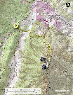
  • Mile 0.0 – The yellow blazed Andy Layne Trail begins at the rear of the parking area on Route 779 (Catawba Road). You'll cross two fence stiles before reaching the first of two bridge crossings of Catawba Creek. In some places over the next mile the trail was overgrown but manageable as of 2011. The first couple of miles you will hear the hum of the Roanoke Cement Co, this is their land they have generously allowed hikers to cross, so to get to the top you will just have to put up with the noise :)
  • Mile 0.6 – Cross the 1st Catawba Creek Bridge, parallel Catawba Creek with unique cliff face on opposite side of creek, then reach the next bridge.
  • Mile 0.8 – Cross the 2nd Catawba Creek Bridge. Start the 200ft climb to the gate.
  • Mile 1.2 – Arrive at the gate, and as long as you stay on the trail you are granted permission to go around the “No Trespassing” sign from the Roanoke Cement Co. The trail bears to the left around the gate, and in 100 yards bears to the right. The next portion begins the tough part of the hike, gaining 900ft+ feet before reaching the Appalachian Trail. One section has no switchbacks for about 0.4 miles.
  • Mile 3.0 – Reach the white blazed A.T. and stay right/south, this area is referred to as Scorched Earth Gap. Continue 0.6 miles south on the A.T. for a beautiful view to the north.
  • Mile 3.6 – View to the northwest of Broad Run Mtn and to the Northeast of Fincastle.
  • Mile 3.8 – 1st view of Catawba Valley but a better viewing area is about 200 yards beyond.
  • Mile 3.85 – 2nd view of Catawba Valley. Great place for lunch and taking in the views. McAfee Knob is clearly visible to the south
  • Mile 7.8 - Retrace your steps to return to the parking area.
Note: If you're adventurous and need more miles, you could continue south on the AT to McAfee Knob, this would be approximately 18 miles roundtrip from the Andy Layne parking area.
Explore 17 trails near Troutville, VA
  1. Parking

    37.457536, -80.017302
  2. Main Trailhead

    37.457214, -80.01729
No community routes found. To add your own hike as a Community Route for this Trail guide, leave a Trip Report with an attached GPX file.

Hazards

Ticks - Lyme Disease More Info (CDC)
Snakes
Poison Ivy/Oak

Seasons

All

Blaze Color

Yellow

Trip Reports

Trail Guide By:
HikingUpward user profile picture
7.1 miles / 11.4 km

Weather Forecast

In Troutville, VA

Explore Hiking Trails

You May Also Like

New York's Best Waterfalls - Whether you're planning a day hike, roadside stop, or a leisurely short walk, this guide provides hikers, travelers, and locals alike with 63 different locations to over 100 scenic waterfalls to help plan your next adventure!
Explore

New York's Best Waterfalls

Whether you're planning a day hike, roadside stop, or a leisurely short walk, this guide provides hikers, travelers, and locals alike with 63 different locations to over 100 scenic waterfalls to help plan your next adventure!

Read
25 Best Day Hikes in North Carolina - Discover the top 25 best day hikes in North Carolina, from breathtaking waterfalls to mountain peaks. Explore hidden gems, scenic views, and trails suitable for all skill levels, perfect for your next outdoor adventure.
Explore

25 Best Day Hikes in North Carolina

Discover the top 25 best day hikes in North Carolina, from breathtaking waterfalls to mountain peaks. Explore hidden gems, scenic views, and trails suitable for all skill levels, perfect for your next outdoor adventure.

Read

Before you boogie...

Find our trail guides useful? Consider becoming a Supporter to unlock perks!

MyHikes is an indie platform that makes exploring public trails easier for everyone. The platform has no investors, no ads, and is owned and operated by one person, Dave Miller. Dave has personally mapped and written over 1,800 trail guides on MyHikes for the public to explore. MyHikes has helped millions outdoor enthusiasts plan their next adventure.

But it takes a lot of time 🕦, money 💰, work, and espresso shots ☕ to run MyHikes, including hiking , mapping , writing , and publishing new trails with high-quality (accurate) information... along with software engineering (coding) the platform like building new features, website and mobile app development (iOS and Android), site maintainance . and much much more.

Supporters unlock website and mobile app perks with an annual one-time payment of $25 (you renew) 😎👍. Or you can simply make a Donation of your choice. Otherwise, you can support us by telling your friends about MyHikes - both quick and free 🎉

Admin user profile picture

Dave Miller
MyHikes Founder