The Thunder Knob Trail at
North Cascades National Park near Diablo, Washington is a moderate 3.4-mile out-and-back hike that leads to stunning views of Diablo Lake's turquoise waters and alpine scenery.
Hike to Thunder Knob
This hike technically begins along the North Cascades Highway at the main parking lot located along the road. Here, you'll find an information kiosk for the Thunder Knob Trail along with a map and other necessary information that hikers need. The trailhead for the Thunder Knob Trail begins at the back of the Colonial Creek North Campground, so you'll have to walk an additional ~600-feet along the campground road to reach it, so plan to add walk a total of 3.6 miles.
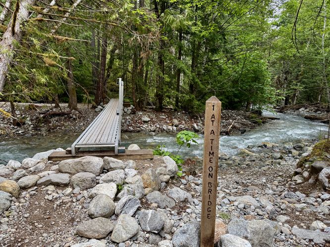
1-At-a-Time Footbridge - Mile 0.12
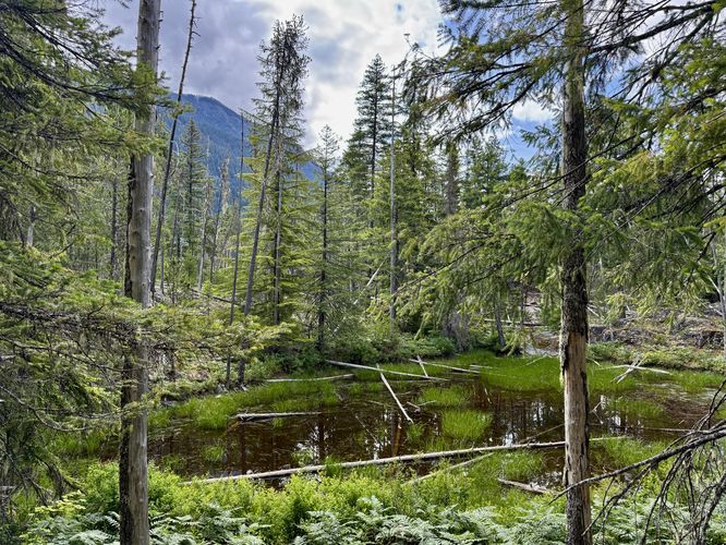
After hopping on the trail, you'll walk through the forest until you reach a footbridge that spans Colonial Creek. Here, you must follow the signage and only allow one person on the bridge at a time.
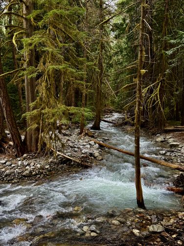
Colonial Creek Scenery - Mile 0.15
Cross Colonial Creek to find yourself on the opposite side where the forest transforms into scenery of lush mosses, ferns, and the turquoise-tinted waters of Colonial Creek. The views of the creek here are unmatched and are some of the most scenic in
North Cascades National Park, requiring little effort to reach. This section of the trail, for the next half-mile, is full of moss-covered trees with scenery of mosses and ferns that cover the forest floor.
Thunder Arm / Diablo Lake View - Mile 0.5
The trail begins to climb Thunder Knob as it follows switchbacks uphill along a moderate grade. Along the way up, around mile 0.5, sits a southeast-facing view of Diablo Lake / Thunder Arm and the bridge of the North Cascades Highway that spans the water. This is a nice spot to take a little break, snap a photo, and grab a drink of water before continuing onward.
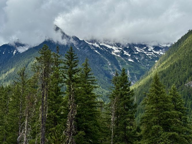
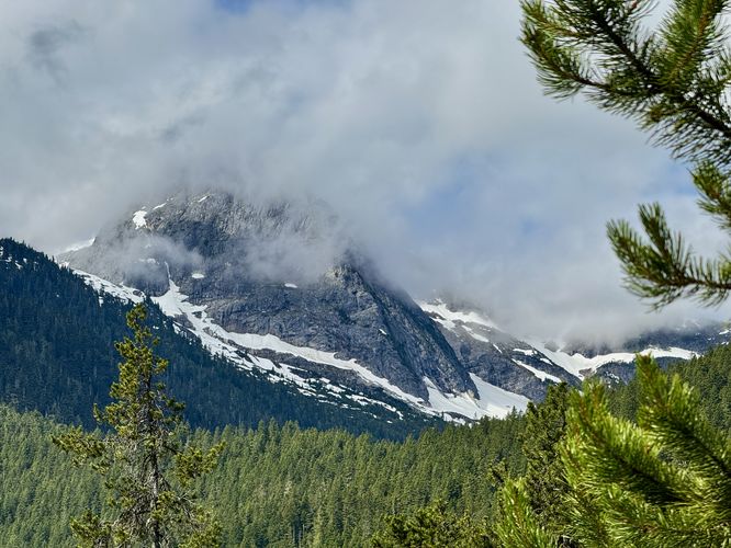
Colonial Glacier & Alpine Vista - Mile 0.85
Follow more switchbacks as the trail continues to ascend Thunder Knob, passing more areas of moss-covered forest, before the trail spits you out onto a bedrock outcropping at mile 0.85. This outcropping provides hikers with a southwest-facing view toward the alpine peaks that surround the Colonial Glacier. During our hike here, we showed up when the clouds were covering the tops of the peaks and thus could only see snowfields below the glacier, but the scenery was just stunning. The mountains had countless thousand-foot tall waterfalls that plummet down their slopes, fed by snow and glacier melt overhead. And regardless of seeing the Colonial Glacier or not, the water it sends down to Diablo Lake is full of rock flour which simply continues the turquoise-hues of the lake which is one of the primary reasons people show up to visit.
Thunder Knob Pond - Mile 1.3
After passing the alpine vista toward the Colonial Glacier, the trail, as you may have guessed, follows more switchbacks as it continues to ascend Thunder Knob. Keeping along the trail as it heads north, you'll eventually reach a small pond that sits just off-trail, around mile 1.3.
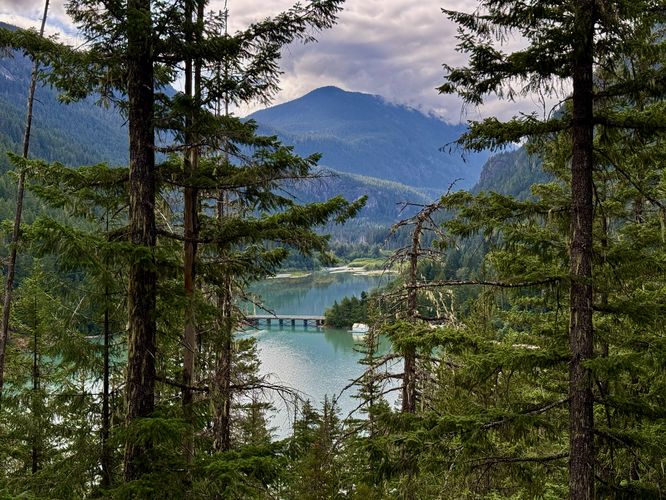
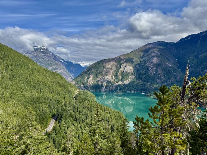
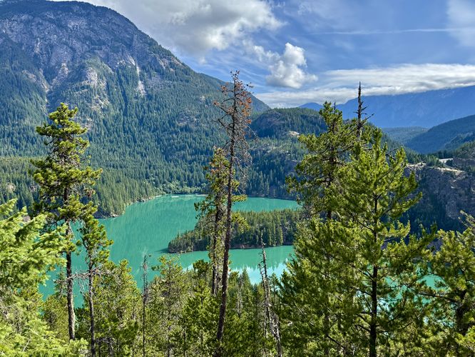
Diablo Lake Vista - Mile 1.6
After passing Thunder Knob Pond, the trail continues north but this time along flatter ground compared to earlier on in the hike. Thunder Knob begins to level out near its peak and so does the trail. Keep an eye out for a left-hand turn that leads to a bench sitting above a tall cliff. Following the short spur trail out, you'll reach a breathtaking view of Diablo Lake around mile 1.6. From the vista, you'll find the North Cascades Highway cutting through the forest on the left-hand side, Davis Peak towering overhead, and the turquoise waters of Diablo Lake on the right. Watch your step near the vista though as there's a fairly steep drop-off / cliff that sits below the bench. If you show up early enough, like we did, you'll have the bench and sweeping views of Diablo Lake all to yourself.
End of Trail & Diablo Lake View - Mile 1.7
After taking in the view from the bench at mile 1.6, hikers may want to explore the very-end of the Thunder Knob Trail. Backtrack to the main path then hike east to reach the last view of Diablo Lake from the trail. Here, you'll find an obstructed, but still very-impressive view of the turquoise waters of Diablo Lake. Located directly across the water is the
Diablo Lake Overlook, which you should have on your bucket list when visiting
North Cascades National Park. From the end of the trail, you can hike down the bedrock outcropping to find different views and perspectives of the water between the obstructing trees.
Hiking Out - Mile 1.7 to 3.4 (3.6)
The hike back to parking is straight forward, just follow the trail back from whence you came. Note that on the way out, you'll have a slightly-different perspective of the surrounding alpine peaks from the trail. From the top of Thunder Knob, near the two vistas, are views of the towering mountains that surround the valley. During early and late hours of the day, this is a pretty good spot to photograph the peaks. You'll have another opportunity to take-in views from the Colonial Glacier & Alpine Vista on your way out too. The trail technically ends at mile 3.4, after crossing the 1-At-a-Time footbridge, but you'll wrap up the hike around mile 3.6 at the parking lot.
Camping
Note that this trail does not allow camping or backpacking on it, however, the trail does start at the Colonial Creek North Campground at the park. If you plan to camp at
North Cascades National Park, consider this campground. Please follow all rules and regulations when camping and acquire a reservation. See the park's official
website for more details.
Restrooms
As of June 2025, this trail has restrooms near the trailhead, which are pit toilets. There are flush toilets in the middle of the campground on your way to / from the trailhead.
Parking & Fees
Hikers will find a medium-sized parking lot at the coordinates provided, located on the north side of the North Cascades Highway. Do not enter the campground unless you have a reservation, as there are no public parking spaces there. You must walk an additional 600-feet from parking to reach the trailhead. As of June 2025, there are no fees to enter
North Cascades National Park, making it one of the few national parks that does not require an entrance fee.
Pets
Dogs are allowed only if leashed and must be cleaned up after.