Loading...

🎆 50%-off 4th of July sale on Supporter Accounts thru July 6th! Learn more

Three Top Mountain Hike

Directions
Map
Pictures
Send to App
Distance:
7.2 Miles / 11.6 km
Type:
Loop
Difficulty:
Moderate
Time to Hike:
3 hours, ~36 minutes
Features:
Surface Type:
Dirt
Park:
George Washington National Forest
Town:
Fort Valley, Virginia
Directions:
38.921471, -78.380585
Added:
February 17, 2025
Updated:
April 05, 2025
Copy Trail Link Hiking this trail? Send a friend or family member a link to this trail guide for your own safety. Hike at your own risk (disclaimer)
Loading...
Loading...
567'

Total Change
972'

Ascent
972'

Descent

Download the Trail Route for Offline Use

Supporters get exclusive access to download trail routes to the MyHikes app for offline use. Stay prepared on your adventure, even without an internet connection! Become a Supporter today to unlock this feature and hike with confidence.

Send to App

Three Top Mountain Hike

Part of the Signal Knob area in the George Washington National Forest, Three Top Mountain with its 3.5 mile stretch along the ridge line is one of the least traveled trails in the area.

The blue blazed Tuscarora Trail has been cleared and re-blazed by a PATC volunteer group, and is in much better shape than pictured here. On the return down the orange blazed FS road, which is part of the Massanutten Trail, the hiking is almost a gentle walk.

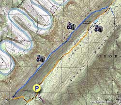
To begin backtrack down the orange blazed FS road you just drove up passing the purple blazed Mudhole Gap Trail in 100 yards where it enters from the left, then in 0.4 miles the orange blazed Massanutten Trail will turn right off the FS road and begin its ascent up Three Top Mountain.

Follow the orange blazed trail as it ascends the mountain and in 0.5 miles reach the intersection of the blue blazed Tuscarora Trail that enters from the right. The orange blazed Massanutten Trail and blue blazed Tuscarora Trail will join and continue straight.

Turn right on the blue blazed trail as it ascends slightly to reach the ridge. For the next 3.5 miles follow the blue blazed trail and ridge line before it begins to descend the mountain to the east/right side.

The blue blazed trail will reach the valley floor and intersection of the orange blazed Massanutten Trail (FS road). Here the blue blazed trail you have been following crosses Little Passage Creek and begins to ascend Green Mountain.

At this intersection turn right to follow the orange blazed FS road (you follow it the entire way back to the parking are) . In 0.5 miles the orange blazed trail will veer off the road to the right.

You can either follow the trail and pass the reservoir on its right or continue on the FS road and pass the reservoir to the left. Either way the FS road and orange blazed Massanutten Trail will rejoin on the other side of the reservoir in 0.3 miles.

Continue on the orange blazed FS road as it follows the valley before crossing Little Passage Creek in 0.2 miles and in another 1.2 miles arrives at a closed gate. 50 yards further the parking lot is on your left.

Explore 94 trails near Fort Valley, VA
  1. Parking

    38.921471, -78.380585
  2. Main Trailhead

    38.922291, -78.380585
No community routes found. To add your own hike as a Community Route for this Trail guide, leave a Trip Report with an attached GPX file.

Hazards

Ticks - Lyme Disease More Info (CDC)
Snakes
Poison Ivy/Oak

Seasons

All

Trip Reports

Trail Guide By:
HikingUpward user profile picture
7.2 miles / 11.6 km

Weather Forecast

In Fort Valley, VA

Explore Hiking Trails

You May Also Like

New York's Best Waterfalls - Whether you're planning a day hike, roadside stop, or a leisurely short walk, this guide provides hikers, travelers, and locals alike with 63 different locations to over 100 scenic waterfalls to help plan your next adventure!
Explore

New York's Best Waterfalls

Whether you're planning a day hike, roadside stop, or a leisurely short walk, this guide provides hikers, travelers, and locals alike with 63 different locations to over 100 scenic waterfalls to help plan your next adventure!

Read
25 Best Day Hikes in North Carolina - Discover the top 25 best day hikes in North Carolina, from breathtaking waterfalls to mountain peaks. Explore hidden gems, scenic views, and trails suitable for all skill levels, perfect for your next outdoor adventure.
Explore

25 Best Day Hikes in North Carolina

Discover the top 25 best day hikes in North Carolina, from breathtaking waterfalls to mountain peaks. Explore hidden gems, scenic views, and trails suitable for all skill levels, perfect for your next outdoor adventure.

Read

Before you boogie...

Find our trail guides useful? Consider becoming a Supporter to unlock perks!

MyHikes is an indie platform that makes exploring public trails easier for everyone. The platform has no investors, no ads, and is owned and operated by one person, Dave Miller. Dave has personally mapped and written over 1,800 trail guides on MyHikes for the public to explore. MyHikes has helped millions outdoor enthusiasts plan their next adventure.

But it takes a lot of time 🕦, money 💰, work, and espresso shots ☕ to run MyHikes, including hiking , mapping , writing , and publishing new trails with high-quality (accurate) information... along with software engineering (coding) the platform like building new features, website and mobile app development (iOS and Android), site maintainance . and much much more.

Supporters unlock website and mobile app perks with an annual one-time payment of $25 (you renew) 😎👍. Or you can simply make a Donation of your choice. Otherwise, you can support us by telling your friends about MyHikes - both quick and free 🎉

Admin user profile picture

Dave Miller
MyHikes Founder