Loading...

🔥 End of Summer sale! 50% off on Supporter Accounts — now through September 1st. Learn More.

Three Falls Hike

Directions
Map
Pictures
Send to App
Distance:
8.1 Miles / 13.0 km
Type:
Loop
Difficulty:
Hard
Time to Hike:
4 hours, ~5 minutes
Features:
Appalachian Trail hike
Surface Type:
Dirt
Park:
Shenandoah National Park
Town:
Mauck, Virginia
Directions:
38.530704, -78.439662
Added:
March 19, 2025
Updated:
April 06, 2025
Guide by:
Copy Trail Link Hiking this trail? Send a friend or family member a link to this trail guide for your own safety. Hike at your own risk (disclaimer)
Loading...
Loading...
1,426'

Total Change
2,310'

Ascent
2,312'

Descent

Download the Trail Route for Offline Use

Supporters get exclusive access to download trail routes to the MyHikes app for offline use. Stay prepared on your adventure, even without an internet connection! Become a Supporter today to unlock this feature and hike with confidence.

Send to App

Three Falls Hike

The Three Falls hike is a circuit that passes Rose River Falls, Dark Hollow Falls, and Lewis Spring Falls. These are three of the most beautiful falls in the SNP. There is also an option of shortening the distance, and vertical gain, by opting out of the Lewis Spring Falls section for a total of 6.1 mls and 1530ft gain.

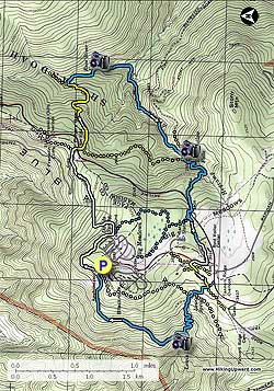
From the trailhead and parking area walk 75 yards down to the intersection of the white blazed Appalachian Trail (AT). Turn right and follow the AT as it initially winds around the campground. There will be several side trails that lead up to the campground, remain left on the white blazed AT.

The AT will start descending before arriving at the next trail post just before the Fishers Gap parking area in 1.3 miles. Stay straight on the AT passing below the Fishers Gap overlook, then the AT will cross a fire road. Turn off the AT uphill on the fire road and cross Skyline Drive.

Start down the gravel fire road, then after passing the chain gate immediately turn left onto the yellow blazed Rose River Horse Trail. Follow the yellow blazed trail as it descend and makes several switchbacks before arriving at the blue blazed Rose River Trail intersection in 0.6 miles.

Stay right on the Rose River Trail for 0.8 miles to Rose River Falls, which are a set if two 25ft and 30ft waterfalls. Continue down the blue blazed trail for another 0.3 miles to the hikes lowest point, and where the trail turns right and starts following Hogcamp Branch. Shortly pass the ruins of an old copper mine on the right before crossing Hogcamp Branch on a steel footbridge. Begin climbing up the blue blazed trail as it ascends the valley passing several small falls and pools before reaching the Rose River Fire Road and the bottom of Dark Hollow Falls in another 0.9 miles.

Cross Hogcamp Branch on the fire road, then immediately turn left uphill on the blue blazed Dark Hollow Trail. In 0.1 miles reach the mid-point of the falls where there is a fantastic view of the upper falls. Continue up the blue blazed trail and arrive at the Dark Hollow Falls parking area in 0.7 miles.

Immediately cross Skyline Drive and start up the paved Nature Trail. In 100 yards turn left at the sign for the Visitor Center crossing a small stone footbridge. In 0.4 miles arrive at the Visitor Center, and just past that a restaurant and gas station..

The next section can be slightly confusing. Across from the restaurant follow the paved path for the Lodge.

  1. For the continuation of the circuit and Lewis Falls section:
    In 0.1 miles there will be a unnamed road on the left, with a sign
    ' Authorized Vehicles Only'. Turn left down the road for 75 yards then turn left on the yellow blazed Bridle Path Trail. Note there isn't trail signage here.

  2. To shorten the hike and return back to the parking area:
    Continue on the paved Lodge path for 0.9 miles following the road to the amphitheater and parking area.

Continuation of the Lewis Falls section:

After turning left on the yellow blazed Bridle Path Trail, cross another yellow blazed trail in 100 yards. Continue to follow the yellow blazed trail to the intersection of the blue blazed gravel fire road in another 0.2 miles.

Turn right downhill on the blue blazed gravel fire road, and in 0.2 miles reach the intersection of the white blazed AT. Continue downward on the fire road for another 150 yards to Lewis Spring. Turn left on the blue blazed Lewis Spring Trail, as it makes several switchbacks then reaches the Overlook Trail intersection in 0.4 miles.

Turn left to go to the valley overlook, and on the other side of the stream is the overlook for Lewis Falls. Return to the Overlook Trail intersection then turn left on the Lewis Spring Falls Trail to continue the hike.

The blue blazed Lewis Spring Trail will descend for another 0.1 miles before turning uphill and arriving at the intersection of the AT in 1.2 miles. Turn left on the AT, and in 50 yards turn right for the remaining 75 yards back to the amphitheater and parking area.

Explore 90 trails near Mauck, VA
  1. Parking

    38.530704, -78.439662
  2. Main Trailhead

    38.530912, -78.439679
No community routes found. To add your own hike as a Community Route for this Trail guide, leave a Trip Report with an attached GPX file.

Hazards

Ticks - Lyme Disease More Info (CDC)
Snakes
Poison Ivy/Oak

Seasons

All

Trip Reports (Reviews)

Rated 3.95 out of 5 based on 41 ratings.
By: Ed Matthews
8.1 miles / 13.0 km
July 24, 2016
We decided to alter the route a bit. We parked out on Skyline Drive at the Lewis Falls trailhead (4 parking spaces at the trailhead, more across the road at the head of the fire road), walked down to Lewis Falls, back around to the AT and Fisher's Gap, down to Rose River, across to Dark Hollow, back up to Skyline Drive and across to where we left the car. We decided to leave the car at the Lewis Falls trailhead because before we started on the hike proper and before the sun got too terribly hot, we wanted to walk across and through the meadow. We added another mile or so to our hike by walking the meadow. Walking the meadow was worth it for me: lots of wildflowers and we even scared up a hen turkey out of the grass. Of the three falls, we liked Lewis the best. Rose River had the best swimming holes (and the least scenic falls). Dark Hollow was jammed with people. Though it looks fairly tame on the map, there is some really good and constant elevation gain. You'll feel it by the end of the day. We came upon a bear just off the Rose River trail. We must have scared it a bit for it jumped up on a log 10 yards from us, puffed up, and gave us a really good growl. But then it shuffled off turning over rocks and logs and feasting away nonchalantly. Lots of deer everywhere, does bedded down in the leaves, a curious fawn which came right up to us, many more that I am sure were within feet of us that we did not see. With the exception of the section of AT that we hiked, these trails were very highly trafficked. You're not going to get any solitude here. That said, the wildflower viewing is the best I've seen this time of year just about anywhere.
Legacy Review
By: Patricia
8.1 miles / 13.0 km
July 24, 2016
This hike was mostly downhill and very rocky. The views were better on the hike than at the falls. Barely anything to look at at Rose River Falls and the swimming hole was shallow and small. Dark Hollow Falls was prettier but still not much to look at and nowhere to swim. We did not make it to the third fall because we got too bored and decided to turn around. Would not recommend.
Legacy Review
By: John Thomas Fisher
8.1 miles / 13.0 km
March 15, 2016
It'd be a nice hike in the summertime, but I'd go ahead and take this one later if you want to hike in the winter/springtime. It was sheet of ice after sheet of ice, and a couple of us slipped and slid down way to close to the edge for anyone's comfort. One buddy had to grab me as I went going down. Beautiful at any rate, but too treacherous for the cold parts of the year.
Legacy Review

Weather Forecast

In Mauck, VA

Explore Hiking Trails

You May Also Like

New York's Best Waterfalls - Whether you're planning a day hike, roadside stop, or a leisurely short walk, this guide provides hikers, travelers, and locals alike with 63 different locations to over 100 scenic waterfalls to help plan your next adventure!
Explore

New York's Best Waterfalls

Whether you're planning a day hike, roadside stop, or a leisurely short walk, this guide provides hikers, travelers, and locals alike with 63 different locations to over 100 scenic waterfalls to help plan your next adventure!

Read
25 Best Day Hikes in North Carolina - Discover the top 25 best day hikes in North Carolina, from breathtaking waterfalls to mountain peaks. Explore hidden gems, scenic views, and trails suitable for all skill levels, perfect for your next outdoor adventure.
Explore

25 Best Day Hikes in North Carolina

Discover the top 25 best day hikes in North Carolina, from breathtaking waterfalls to mountain peaks. Explore hidden gems, scenic views, and trails suitable for all skill levels, perfect for your next outdoor adventure.

Read

Before you boogie...

Find our trail guides useful? Consider becoming a Supporter to unlock perks!

MyHikes is an indie platform that makes exploring public trails easier for everyone. The platform has no investors, no ads, and is owned and operated by one person, Dave Miller. Dave has personally mapped and written over 1,800 trail guides on MyHikes for the public to explore. MyHikes has helped millions outdoor enthusiasts plan their next adventure.

But it takes a lot of time 🕦, money 💰, work, and espresso shots ☕ to run MyHikes, including hiking , mapping , writing , and publishing new trails with high-quality (accurate) information... along with software engineering (coding) the platform like building new features, website and mobile app development (iOS and Android), site maintainance . and much much more.

Supporters unlock website and mobile app perks with an annual one-time payment of $25 (you renew) 😎👍. Or you can simply make a Donation of your choice. Otherwise, you can support us by telling your friends about MyHikes - both quick and free 🎉

Admin user profile picture

Dave Miller
MyHikes Founder