Loading...

Distance:
0.2 Miles / 0.3 km
Type:
Out-and-Back
Difficulty:
Easy
Time to Hike:
~6 minutes
Features:
PA Wilds
Surface Type:
Dirt
Park:
Round Top Park
Town:
Athens, Pennsylvania
Directions:
41.95184, -76.531097
Added:
May 28, 2023
Updated:
June 11, 2023
Loading...
Loading...
20 '

Total Change
20 '

Ascent
20 '

Descent

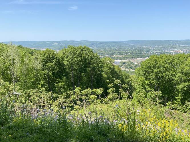
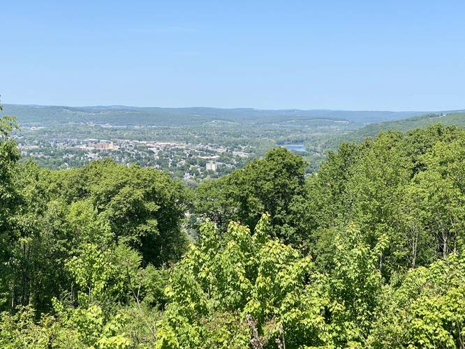
The Valley Overlook at Round Top Park in Athens, Pennsylvania is an easy 0.2-mile out-and-back walk that features two overlooks with views of the Sayre, PA Athens, PA and Waverly, NY - also known as "The Valley".

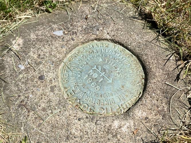
This is not a hike but rather a quick walk through Round Top Park that connects two overlooks. Visitors will find the western-most overlook includes views of the Susquehanna River. Visitors can also locate an old U.S. Coast and Geodetic Survey marker (control point) at the western-most overlook as well. Each overlook, as of May 2023, included swing benches for visitors to sit and enjoy the views.

Hours
Round Top Park is open from sunrise to sunset every day. There's a gate along the entrance road that might be opened/closed at those times each day; however, that was unclear from our visit. Don't get stuck inside if that's the case.

Parking
Visitors will find parking turnouts by the coordinates provided at Round Top Park.

Pets
Dogs are allowed if leashed and must be cleaned up after.

Explore 50 trails near Athens, PA
  1. Parking

    41.95184, -76.531097
  2. Main Trailhead

    41.95184, -76.531097
  3. The Valley Overlook

    41.952122, -76.531114
    The Valley Overlook
  4. U.S. Coast & Geological Survey marker (1968) - Athens, PA

    41.952194, -76.531997
    U.S. Coast & Geological Survey marker (1968) - Athens, PA
  5. The Valley Overlook

    41.952206, -76.532075
    The Valley Overlook
No community routes found. To add your own hike as a Community Route for this Trail guide, leave a Trip Report with an attached GPX file.

Hazards

Ticks - Lyme Disease More Info (CDC)

Seasons

All

Photo Albums

2 Trip Reports

No Star-Ratings
Write-up by:
Admin user profile picture
0.2 miles / 0.3 km
Trail added
May 28, 2023
Hiked on
May 28, 2023
Updated on
June 11, 2023
0.2 miles / 0.3 km
May 28, 2023
Dogs Hiking

Weather Forecast

In Athens, PA

Explore Hiking Trails

New Hikes

Keshequa Creek Falls Trail
2.9 Miles
4.7 km
Easy
Out-and-Back
Diana's Baths Trail
1.2 Miles
1.9 km
Easy
Out-and-Back
Raven Rocks via Appalachian Trail
5.1 Miles
8.2 km
Strenuous
Out-and-Back
Bates Ferry Trail and General Greene Tree
2.7 Miles
4.3 km
Easy
Out-and-Back

Before you leave...

MyHikes is an indie web platform aimed to make exploring public trails easier for everyone. The site has no investors and is owned and operated by one person, Dave Miller (Founder & Admin). As the Founder, main contributor, and doer-of-all-things for MyHikes, I share my trips with over-detailed write-ups for fun on a volunteer basis and I believe that public trail information should be available to everyone.

It takes a lot of time 🕦, money 💰, and effort (including espresso shots ☕) to run MyHikes, including hiking , mapping , writing , and publishing new trails with high-quality content... along with building new features, moderating, site maintainance, and app development for iOS and Android . I simply ask that if you find MyHikes' trail guides helpful to please consider becoming a Supporter to help keep the site, iOS, and Android apps available to everyone.

Supporters unlock website and in-app perks with a one-time payment of $25 (you renew) 😎👍. Or you can simply make a Donation of your choice without a MyHikes user account. Otherwise, telling your friends about MyHikes is the next-best thing - both quick and free 🎉

Thanks for visiting MyHikes and have a great hike!️

Admin user profile picture

Dave Miller
MyHikes Founder & Admin