Loading...

🎉 Enjoy a Free 7-Day Supporter Trial and Unlock Exclusive Perks — No Credit Card Required. Learn more.

The Peak Hike

Directions
Map
Pictures
Send to App
Distance:
15.5 Miles / 24.9 km
Type:
Loop
Difficulty:
Strenuous
Time to Hike:
7 hours, ~45 minutes
Features:
Appalachian Trail hike
Surface Type:
Dirt
Park:
Shenandoah National Park
Town:
Bentonville, Virginia
Directions:
38.767834, -78.233299
Added:
March 19, 2025
Updated:
April 06, 2025
Copy Trail Link Hiking this trail? Send a friend or family member a link to this trail guide for your own safety. Hike at your own risk (disclaimer)
Loading...
Loading...
1,454'

Total Change
3,322'

Ascent
3,320'

Descent

Download the Trail Route for Offline Use

Supporters get exclusive access to download trail routes to the MyHikes app for offline use. Stay prepared on your adventure, even without an internet connection! Become a Supporter today to unlock this feature and hike with confidence.

Send to App

The Peak Hike

One of the toughest day hikes in the entire SNP. The Peak circuit has spectacular views along the AT and Marshall Mountain, and a grueling straight up and down climb of The Peak two thirds along the hike. You also have the option of making this significantly easier and shorter by 3.0 miles, and not doing The Peak out/back to the summit.

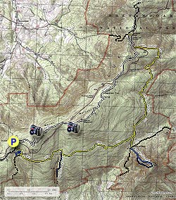
If you are looking for a good workout with plenty of views this may be the hike for you! Also, if you plan on doing The Peak out/back make sure to start early, as this makes the total hike time over 7 hours. It's a steep climb. Check out the profile at mile 11.

From the parking area at Gravel Springs Gap, cross Skyline Drive and turn right on the white blazed Appalachian Trail (AT). In 0.9 miles arrive at the first good overlook towards the west, and of the south fork of the Shenandoah River. In another 0.8 miles re-cross Skyline Drive and shortly pass a parking area on the left. In 0.2 miles the trail will make a turn to the right and climb to a rock outcropping where the AT turns back to the left. Climb up the rocky outcrop for the best view of the hike. Continue along the AT crossing Skyline Drive once again in 1.9 miles, then in another 1.5 miles the AT will begin to descend and arrive at the yellow blazed Jenkins Gap Trail.

Turn right on the Jenkins Gap Trail, pass through the parking area, and cross Skyline Drive. Turn right and continue next to Skyline Drive (no trail) for 0.2 miles to the Mount Marshall trailhead. Turn left down the yellow blazed Mount Marshall Trail as it winds around the mountain crossing Waterfall Branch, and Sprucepine Branch before arriving at the intersection of the Bluff Trail in 3.5 miles.

The Peak now is directly in front of you :) Again, there are no views at the summit, but it's a great workout. If you decide NOT to do The Peak out/back turn right here onto the Bluff Trail.

For The Peak out/back continue straight on the Mount Marshall Trail for another 0.4 miles to Thoroughfare Gap and intersection of the Jordan River Trail. The abandoned blue blazed Peak Trail is directly ahead going straight up the ridge. The trail is hard to locate for the first 100 yards, then climbs the ridge steeply for 0.3 miles where there is a small rock cairn indicating the turn left. Pick up the trail again and continue along the ridge for the remaining 0.5 miles to the tree covered summit. Return by following your path back to Thoroughfare Gap, then back to the intersection of the Bluff Trail.

Turn left on the yellow blazed Bluff Trail as it winds around the mountain for 2.3 miles to the intersection of the blue blazed Big Devils Stairs Trail. Stay straight on the Bluff Trail for another 1.4 miles arriving at the next intersection where the Bluff Trail turns left. Turn right uphill for 0.1 miles to the intersection of the horse trail and turn right again for 0.1 miles to the yellow blazed fire road. Turn right uphill on the fire road for the remaining 0.3 miles back to the Gravel Springs parking area.

Explore 90 trails near Bentonville, VA
  1. Parking

    38.767834, -78.233299
  2. Main Trailhead

    38.767904, -78.2336
No community routes found. To add your own hike as a Community Route for this Trail guide, leave a Trip Report with an attached GPX file.

Hazards

Ticks - Lyme Disease More Info (CDC)
Snakes
Poison Ivy/Oak

Seasons

All

Trip Reports

Trail Guide By:
HikingUpward user profile picture
15.5 miles / 24.9 km

Weather Forecast

In Bentonville, VA

Explore Hiking Trails

You May Also Like

New York's Best Waterfalls - Whether you're planning a day hike, roadside stop, or a leisurely short walk, this guide provides hikers, travelers, and locals alike with 63 different locations to over 100 scenic waterfalls to help plan your next adventure!
Explore

New York's Best Waterfalls

Whether you're planning a day hike, roadside stop, or a leisurely short walk, this guide provides hikers, travelers, and locals alike with 63 different locations to over 100 scenic waterfalls to help plan your next adventure!

Read
25 Best Day Hikes in North Carolina - Discover the top 25 best day hikes in North Carolina, from breathtaking waterfalls to mountain peaks. Explore hidden gems, scenic views, and trails suitable for all skill levels, perfect for your next outdoor adventure.
Explore

25 Best Day Hikes in North Carolina

Discover the top 25 best day hikes in North Carolina, from breathtaking waterfalls to mountain peaks. Explore hidden gems, scenic views, and trails suitable for all skill levels, perfect for your next outdoor adventure.

Read

Before you boogie...

Find our trail guides useful? Consider becoming a Supporter to unlock perks!

MyHikes is an indie platform that makes exploring public trails easier for everyone. The platform has no investors, no ads, and is owned and operated by one person, Dave Miller. Dave has personally mapped and written over 1,800 trail guides on MyHikes for the public to explore. MyHikes has helped millions outdoor enthusiasts plan their next adventure.

But it takes a lot of time 🕦, money 💰, work, and espresso shots ☕ to run MyHikes, including hiking , mapping , writing , and publishing new trails with high-quality (accurate) information... along with software engineering (coding) the platform like building new features, website and mobile app development (iOS and Android), site maintainance . and much much more.

Supporters unlock website and mobile app perks with an annual one-time payment of $25 (you renew) 😎👍. Or you can simply make a Donation of your choice. Otherwise, you can support us by telling your friends about MyHikes - both quick and free 🎉

Admin user profile picture

Dave Miller
MyHikes Founder