Loading...

🎉 Enjoy a Free 7-Day Supporter Trial and Unlock Exclusive Perks — No Credit Card Required. Learn more.

The Cascades and Barney's Wall Hike

Directions
Map
Pictures
Send to App
Distance:
7.7 Miles / 12.4 km
Type:
Out-and-Back
Difficulty:
Moderate
Time to Hike:
3 hours, ~51 minutes
Features:
Surface Type:
Dirt
Park:
Jefferson National Forest
Town:
Ripplemead, Virginia
Directions:
37.353371, -80.599693
Added:
February 28, 2025
Updated:
April 05, 2025
Copy Trail Link Hiking this trail? Send a friend or family member a link to this trail guide for your own safety. Hike at your own risk (disclaimer)
Loading...
Loading...
1,575'

Total Change
1,836'

Ascent
1,835'

Descent

Download the Trail Route for Offline Use

Supporters get exclusive access to download trail routes to the MyHikes app for offline use. Stay prepared on your adventure, even without an internet connection! Become a Supporter today to unlock this feature and hike with confidence.

Send to App

The Cascades and Barney's Wall Hike

Near Pembroke, in Southwest VA, is one of the most beautiful waterfall and creek trails in Virginia in our opinion. The hike up the lower trail is one photo opportunity after the other with the trail never going further than 30 yards from Little Stony Creek before finally reaching the amazing lower falls.

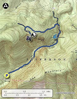
See HU Note below about directions to the Upper Falls sent to us by one of our hikers. This hike can be done as a 4 mile round trip to the 69’ foot lower falls (800’ Elev gain) or as an 8 mile round trip (1600’ Elev gain) taking in the lower falls and Barney’s Wall to see 700’ foot sheer cliffs with great views of the New River Valley. This is a very popular hike on the weekends so come early, do the falls, and then proceed to Barney’s Wall for a little more solitude.

HU Note: For our hikers who are movie buffs, this hike is minutes away from Mountain Lake Conservancy & Hotel where much of “Dirty Dancing” was filmed. We stopped here for dinner on the way home, great food and service!

The un-blazed trail begins to the right of the bathroom and Information Center at the far end of the parking lot. Very quickly you will arrive at the first bridge. We chose to go across the bridge and take the lower trail as we heard it was the more picturesque of the 2 trails. You could return on the upper trail if desired to get a different perspective of the creek. The lower trail weaves its way alongside the creek for a mile before reaching the second bridge and rejoining the upper trail. Keep your eyes open for remnants (stairs to no where) of the trail that were destroyed in the 1996 flood. From the 2nd bridge to the lower falls is about 1 mile with many more places to stop and take photos. The lower falls will come into view as you pass a large boulder. Your time to do this trail will depend largely on how often you stop and how much time you spend “soaking” in the views and possibly taking in a dip in the large pool below the falls. This is the turn-around point if you decide not to continue to Barney’s Wall. Retrace your steps down either the Lower Trail or take the Upper Trail when you get to that intersection at the 2nd large bridge you crossed earlier.

To continue to Barney’s Wall, head up the wooden stairs taking a left onto the trail instead of a right to the falls observation deck. In about 200 yards you will reach an open area with a sign post directing you to the Conservancy Trail. It is a fire road for 0.4 miles. At the fork in the road bear left and take another left in about 50 yards at the Conservancy Trail sign post. It is more of a trail from this point on and is Yellow-blazed. This is a pleasant uphill walk in the woods, crossing a small creek and finally reaching the Barney’s Wall intersection on the left in 1.1 miles. The sign was leaning against a tree so keep alert as it could be easy to miss. The spur trail to Barney’s Wall (0.4 miles) is also yellow-blazed and passes through a few seemingly healthy stands of Hemlocks, a rare treat in VA these days! Just before the cliffs you will see a campsite (not sure of the camping rules since this land is conservancy property), the trail bears to the right of the campsite. You will have a great view of the New River Valley looking over towards Blacksburg. If you have no fear of heights, lie on your stomach and look over the edge to get an idea of how tall the cliffs are. As always, be careful near cliffs, especially when wet. This is a great place for lunch, you may even have company (Eastern Fence Lizard) and if you listen carefully towards the south-east, you will hear the roar of Little Stony Creek.

From this point turn around and retrace your route back past the lower falls and to The Cascades parking area.

HU Note: There is a second set of falls about 0.5 miles beyond the lower falls. The upper falls can be reached by continuing along the trail that runs to the left of the lower falls (the same one you used to reach Barney's Wall). Exactly one half mile above the lower falls there is an unmarked but well established path on the right that leads downhill. You should be able to hear the falls from the turn and they are located about a tenth of a mile down the hill. (Photo and directions courtesy of Kyle K.)

Explore 9 trails near Ripplemead, VA
  1. Parking

    37.353371, -80.599693
  2. Main Trailhead

    37.352983, -80.599694
No community routes found. To add your own hike as a Community Route for this Trail guide, leave a Trip Report with an attached GPX file.

Hazards

Ticks - Lyme Disease More Info (CDC)
Snakes
Poison Ivy/Oak

Seasons

All

Blaze Color

Blue

Trip Reports

Trail Guide By:
HikingUpward user profile picture
7.7 miles / 12.4 km

Weather Forecast

In Ripplemead, VA

Explore Hiking Trails

You May Also Like

New York's Best Waterfalls - Whether you're planning a day hike, roadside stop, or a leisurely short walk, this guide provides hikers, travelers, and locals alike with 63 different locations to over 100 scenic waterfalls to help plan your next adventure!
Explore

New York's Best Waterfalls

Whether you're planning a day hike, roadside stop, or a leisurely short walk, this guide provides hikers, travelers, and locals alike with 63 different locations to over 100 scenic waterfalls to help plan your next adventure!

Read
25 Best Day Hikes in North Carolina - Discover the top 25 best day hikes in North Carolina, from breathtaking waterfalls to mountain peaks. Explore hidden gems, scenic views, and trails suitable for all skill levels, perfect for your next outdoor adventure.
Explore

25 Best Day Hikes in North Carolina

Discover the top 25 best day hikes in North Carolina, from breathtaking waterfalls to mountain peaks. Explore hidden gems, scenic views, and trails suitable for all skill levels, perfect for your next outdoor adventure.

Read

Before you boogie...

Find our trail guides useful? Consider becoming a Supporter to unlock perks!

MyHikes is an indie platform that makes exploring public trails easier for everyone. The platform has no investors, no ads, and is owned and operated by one person, Dave Miller. Dave has personally mapped and written over 1,800 trail guides on MyHikes for the public to explore. MyHikes has helped millions outdoor enthusiasts plan their next adventure.

But it takes a lot of time 🕦, money 💰, work, and espresso shots ☕ to run MyHikes, including hiking , mapping , writing , and publishing new trails with high-quality (accurate) information... along with software engineering (coding) the platform like building new features, website and mobile app development (iOS and Android), site maintainance . and much much more.

Supporters unlock website and mobile app perks with an annual one-time payment of $25 (you renew) 😎👍. Or you can simply make a Donation of your choice. Otherwise, you can support us by telling your friends about MyHikes - both quick and free 🎉

Admin user profile picture

Dave Miller
MyHikes Founder