Tew Falls Trail at Spencer Gorge Conservation Area in Hamilton,Ontario is an easy 1 km out-and-back hike that leads to two viewing platforms of the 41 m (134.5-foot) tall free-falling waterfall known as Tew Falls.
Hike
This hike begins at the very end of the parking area at Spencer Gorge Conservation Area where hikers will find a main trailhead. As of August 2024, there's additional signage that leads hikers through the parking lot for Tew Falls to reach a different trailhead; however, I enjoy the less open forested gorge hike better, so we started at the southern end of the parking lot and hopped on the blue blazed trail, Tew Falls Side Trail.
The Tew Falls Side Trail (blue blazes) runs north along the western side of the super steep Spencer Gorge. There's a small fork in the trail that leads to a fenced area, jutting out further into the gorge, located on the western side -- there's nothing special here but you can listen to the cascade of Tew Falls from here as you make your way closer to the waterfall.
The trail then bends to the east as it approaches Harvest Road, before heading due-south. The trail crosses a footbridge with signage reminding visitors to stay away from the edge of the cliffs as the fall danger here is extreme with sheer cliffs.
Tew Falls Lookout - 0.42 km
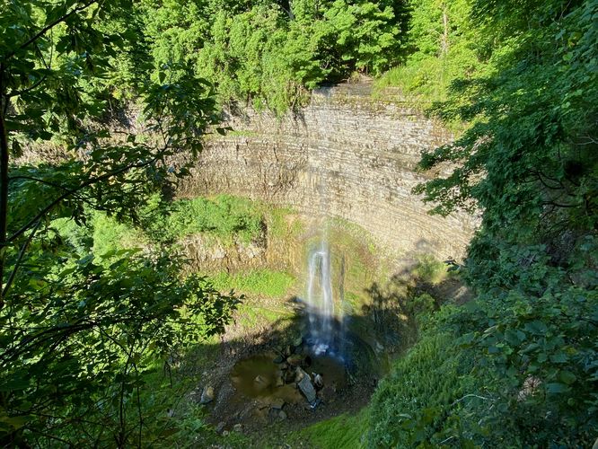
Around 0.42 km into the hike, you'll reach the best viewing platform of Tew Falls from the east side of Spencer Gorge. Here, you can capture the 41m / 134.5-foot tall waterfall in all its glory as it cascades over one of the tallest sheer cliffs along the Niagara Escarpment. During our hike here in August 2024, the waterfall wasn't flowing too heavily, but enough water plummeted over the edge to capture this beautiful cascade on the lower half of its free-falling plunge.
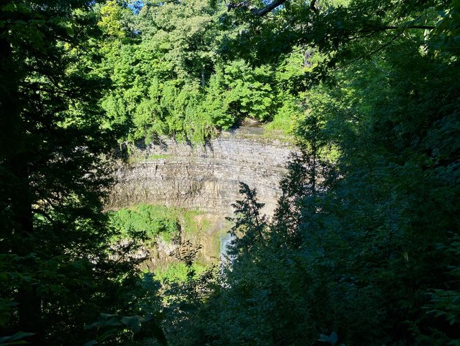
Before leaving, if you want to check out a 2nd lookout, you can hike just a few extra meters to reach another lookout platform of Tew Falls, located around 0.5 km. This second viewing platform, during warm months with lots of vegetation, is less impressive than the first. Note that there's a series of stairs that leads uphill to reach this view of Tew Falls.
The hike back is simple, it leads right back to parking the same way you hiked-in for a short 1 km out-and-back hike to Tew Falls.
Parking & Fees
Hikers will find a large parking lot at the main entrance for Spencer Gorge Conservation Area, located on the south side of Harvest Road in Hamilton, Ontario. The lot is large enough to fit a few dozen vehicles as of August 2024. Note that there's an entrance fee per park within the Hamilton Conservation Authority. For the most updated information, please check out the park's website for entrance fee information. During our visit in August 2024, we purchased a day pass good for all of HCA's properties, which cost ~$35 or so.
Pets
Dogs are allowed only if leashed and must be cleaned up after.
Warning
Steep cliffs: This hike leads to steep cliffs with sheer drop-offs. Stay back from the ledges and stay on-trail for your own safety.
Hike
This hike begins at the very end of the parking area at Spencer Gorge Conservation Area where hikers will find a main trailhead. As of August 2024, there's additional signage that leads hikers through the parking lot for Tew Falls to reach a different trailhead; however, I enjoy the less open forested gorge hike better, so we started at the southern end of the parking lot and hopped on the blue blazed trail, Tew Falls Side Trail.
The Tew Falls Side Trail (blue blazes) runs north along the western side of the super steep Spencer Gorge. There's a small fork in the trail that leads to a fenced area, jutting out further into the gorge, located on the western side -- there's nothing special here but you can listen to the cascade of Tew Falls from here as you make your way closer to the waterfall.
The trail then bends to the east as it approaches Harvest Road, before heading due-south. The trail crosses a footbridge with signage reminding visitors to stay away from the edge of the cliffs as the fall danger here is extreme with sheer cliffs.
Tew Falls Lookout - 0.42 km
Around 0.42 km into the hike, you'll reach the best viewing platform of Tew Falls from the east side of Spencer Gorge. Here, you can capture the 41m / 134.5-foot tall waterfall in all its glory as it cascades over one of the tallest sheer cliffs along the Niagara Escarpment. During our hike here in August 2024, the waterfall wasn't flowing too heavily, but enough water plummeted over the edge to capture this beautiful cascade on the lower half of its free-falling plunge.
Before leaving, if you want to check out a 2nd lookout, you can hike just a few extra meters to reach another lookout platform of Tew Falls, located around 0.5 km. This second viewing platform, during warm months with lots of vegetation, is less impressive than the first. Note that there's a series of stairs that leads uphill to reach this view of Tew Falls.
The hike back is simple, it leads right back to parking the same way you hiked-in for a short 1 km out-and-back hike to Tew Falls.
Parking & Fees
Hikers will find a large parking lot at the main entrance for Spencer Gorge Conservation Area, located on the south side of Harvest Road in Hamilton, Ontario. The lot is large enough to fit a few dozen vehicles as of August 2024. Note that there's an entrance fee per park within the Hamilton Conservation Authority. For the most updated information, please check out the park's website for entrance fee information. During our visit in August 2024, we purchased a day pass good for all of HCA's properties, which cost ~$35 or so.
Pets
Dogs are allowed only if leashed and must be cleaned up after.
Warning
Steep cliffs: This hike leads to steep cliffs with sheer drop-offs. Stay back from the ledges and stay on-trail for your own safety.