Loading...

๐Ÿ‚ Prep for Fall! Unlock exclusive features to plan your perfect late-summer and autumn hikes โ€” become a Supporter today. Learn more.

Terrapin Mountain Hike

Directions
Map
Pictures
Send to App
Distance:
9.6 Miles / 15.4 km
Type:
Loop
Difficulty:
Hard
Time to Hike:
4 hours, ~48 minutes
Features:
Surface Type:
Dirt
Park:
Jefferson National Forest
Town:
Big Island, Virginia
Directions:
37.530885, -79.428252
Added:
February 28, 2025
Updated:
April 05, 2025
Guide by:
Copy Trail Link Hiking this trail? Send a friend or family member a link to this trail guide for your own safety. Hike at your own risk (disclaimer)
Loading...
Loading...
2,189'

Total Change
2,424'

Ascent
2,409'

Descent

Download the Trail Route for Offline Use

Supporters get exclusive access to download trail routes to the MyHikes app for offline use. Stay prepared on your adventure, even without an internet connection! Become a Supporter today to unlock this feature and hike with confidence.

Send to App

Key Takeaways

  • The Terrapin Mountain Trail near Big Island, VA, offers a 9.6-mile loop or a shorter out-and-back option, making it a good choice for cold-season hiking due to its eastern location and winter views.
  • The full loop includes diverse terrain, such as forest roads along Reed Creek, scenic overlooks of Apple Orchard Mountain and the Peaks of Otter, and a surprise waterfall near the end.
  • The trail has key junctions that require careful navigation, particularly at mile 2.8 for the summit trail and at mile 3.8 to ensure a proper loop direction away from the forest road at Camping Gap.

Terrapin Mountain Hike

The Terrapin Mountain Trail in Jefferson National Forest is an excellent cold season option because of its abundant winter views and easy access on the eastern side of the Blue Ridge Parkway. It also has the benefit of lying due east of the largest Blue Ridge Mountains in Virginia, protecting it from the harsh west winds in the winter. You can try the short but steep out-and-back to Terrapin Mountain, or tackle the full loop which mostly follows forest roads along Reed Creek and tributaries on the return. From two overlooks youโ€™ll have fantastic views of Apple Orchard Mountain, Thunder Ridge, and the Peaks of Otter. If you choose to take the entire loop, youโ€™ll be treated to a surprise waterfall beside the trail near the end of the hike.
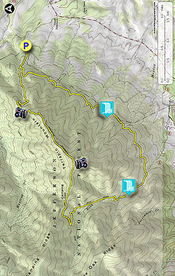
  • Mile 0.0 โ€“ Parking for Terrapin Mountain Trail [5] (yellow blaze).
  • Mile 0.4 โ€“ Intersection with the loop trail. If you turn left to hike the loop clockwise you will reach Reed Creek first. Continue straight towards Terrapin Mountain and immediately veer left at the giant rock cairn while the forest road continues right. You should see yellow blazes on trees ahead.
  • Mile 1.0 โ€“ After long, steep climb the trail makes a hard right turn away from the mountain onto a level track.
  • Mile 1.2 โ€“ Trail makes a U-turn to follow the ridgeline southwest while a faint trail continues northeast.
  • Mile 1.5 โ€“ Rock overlook on the north/right side of the trail. From here you will have 180ยฐ views from west to east including the FAA Radome on Apple Orchard Mountain, Thunder Ridge, Hunting Creek basin, peaks of the James River Face Wilderness, and Big Rocky Row.
  • Mile 2.0 โ€“ The trail levels out on a narrow ridge below a false summit. A faint โ€œtrailโ€ follows the crest north along the rocky false summit for a few hundred yards. There are decent views of Terrapin Mountain and the eastern foothills.
  • Mile 2.7 โ€“ Huge boulders on the right side of the trail with a view north. After passing these massive rocks begin looking for the faint summit trail veering left away from the main trail.
  • Mile 2.8 โ€“ IMPORTANT trail junction - Y-junction with the main trail veering right while the summit trail to the top of Terrapin Mountain goes left and immediately climbs over boulders. The trail heading right looks like the only trail here and the faint summit trail on the left is very easy to miss.
  • Mile 3.0 โ€“ Summit of Terrapin Mountain. The trail turns right heading downhill to meet the main trail. Go left for views from a rock overlook.
  • Mile 3.1 โ€“ A rock pinnacle juts out of the mountain with big southern views. Going from east to west you have a panoramic vista of No Business Mountain, the foothills surrounding the Big Otter River basin, the Peaks of Otter, Headforemost Mountain, Onion Mountain, Apple Orchard Mountain, and Thunder Ridge. Turn left on the trail heading steeply downhill from the summit.
  • Mile 3.3 โ€“ Y-junction with the main trail. Continue straight towards Camping Gap.
  • Mile 3.8 โ€“ The hiking trail turns left downhill ending at a T-junction with a forest road. Turn right following the road downhill towards the obvious grassy area beside the wide turn of Hunting Creek Rd at Camping Gap. IMPORTANT - Turn left from the grassy Camping Gap very briefly following Hunting Creek Rd then turn left at a trail sign for Reed Creek leaving the forest road. If you do not see this national forest sign beside the road soon after Camping Gap you have gone in the opposite direction.
  • Mile 4.3 โ€“ T junction with a forest road, double blazes indicate a left turn.
  • Mile 5.4 โ€“ Wet crossing of Reed Creek. There is a campsite beside the trail before the creek crossing.
  • Mile 5.6 โ€“ Rock hop over a tributary that spills into the forest road.
  • Mile 5.8 โ€“ A forest road spur on the left leads down to a nice series of cascades along Reed Creek.
  • Mile 6.3 โ€“ T-junction at a trail sign for the loop trail and Reed Creek Rd. The main forest road continues straight eventually becomes Reed Creek Rd. Turn left here and encounter the second wet crossing over Reed Creek.    
  • Mile 7.3 โ€“ Rock hop over Meadow Creek.
  • Mile 7.7 โ€“ Rock hop over tributary to Meadow Creek. Immediately to the left of the crossing is a 20 foot waterfall over a wide cliff.
  • Mile 8.2 โ€“ Rock hop over tributary.
  • Mile 8.4 โ€“ Rock hop over tributary.
  • Mile 8.9 โ€“ Rock hop over tributary.
  • Mile 9.5 โ€“ T-junction with Terrapin Mountain Trail loop. Turn right heading towards the parking area.
  • Mile 9.6 โ€“ Hike ends at the Terrapin Mountain Trail parking area.
By HikingUpward contributor: Zach Robbins
Explore 24 trails near Big Island, VA
  1. Parking

    37.530885, -79.428252
  2. Main Trailhead

    37.530931, -79.428105
No community routes found. To add your own hike as a Community Route for this Trail guide, leave a Trip Report with an attached GPX file.

Hazards

Ticks - Lyme Disease More Info (CDC)
Snakes
Poison Ivy/Oak

Seasons

All

Blaze Color

Yellow

Photo Albums

+ Add Photo Album

Upload your photos from the trail to help others know what to expect.

Trip Reports (Reviews)

Rated 4.0 out of 5 based on 10 ratings.
By: Glenn
9.6 miles / 15.4 km
June 26, 2019
Hiked to the summit counterclockwise and back on a low humidity, blue sky day and found the hike very enjoyable. Just note that the path follows a rock scree for a short while and trail markings are sparse. Look for rock cairns to mark the path. Also along the ridge the path is quite overgrown with vegetation and I would recommend long pants as I picked up two ticks along the way.
Legacy Review
By: Brian
9.6 miles / 15.4 km
March 29, 2019
Took a Friday off from work on a beautiful 75 degree spring day to finally do the Terrapin Mountain loop. I parked at the gate on Terrapin Mountain Lane and followed the instructions above by walking the trail counterclockwise. The first 3 miles to the summit were as just as promised, very challenging indeed. I was glad about my decision to bring my trekking poles along for this one. I was somewhat worried about the previous reports of this trail being poorly marked, but it has obviously been improved since those reports. The yellow blazes weren't hard to follow and there are brand new signs marking the forks in the trail. I did bring along a printout of the directions and found them to be pretty accurate. There is a short trail on the left at the false summit just before the summit that leads to a rock outcropping, it's worth checking out so don't miss it. There is no sign for it, everything else appeared to be marked. A previous poster said the terrapin rock formation is visible from the summit, but if you look back at the summit after descending down the other side you'll clearly see the rock you were sitting on for those sweet views actually looks like a giant turtle. I spent a while at the summit, taking in the views of the Peaks of Otter range while listening to a sweet 16-minute rendition of "Terrapin Station" on my phone. I usually don't break my rule of no technology on the trail, but today it seemed appropriate for the occasion. The creek crossings weren't bad today, but I could see where they would be difficult after any signifiant amount of rain. I would highly recommend doing this hike while the leaves are still off the trees, I had a lot of nice views that would not be possible if the trees were green. The downed trees that previously blocked the trail had been sawed up and the trail was completely clear of any obstacles. This hike is not easy, but not as tough as the the nearby Three Ridges Wilderness loop in Nelson County. Once you make it to the summit, the worst part is over. The last 7+ miles are easier that the first 3 miles in my opinion. I thoroughly enjoyed this hike and plan to return soon for an overnight backpacking trip with friends. I spotted several good camping spots down near Reed Creek. "Some rise, some fall, some climb, to get to Terrapin"
Legacy Review
By: Mike
9.6 miles / 15.4 km
October 13, 2018
This was a great hike and I don't think I have a lot to add beyond what has already been said, but I do want to let everyone know about two things --- They have added a sign at the intersection mentioned at mile 2.8. It's gone from "very easy to miss" to almost impossible to miss. --- And there are a lot of downed trees along this route due to the hurricane remnants that came through a few days ago. It shouldn't prevent you from doing the hike, but you will have to go through or over them. Some of them are very large (several were a foot or two in diameter), so just be prepared or wait a while before doing this hike. Overall, a great hike with a lot of variety (waterfalls, a variety of foliage, and massive view)!
Legacy Review

Weather Forecast

In Big Island, VA

Explore Hiking Trails

You May Also Like

New York's Best Waterfalls - Whether you're planning a day hike, roadside stop, or a leisurely short walk, this guide provides hikers, travelers, and locals alike with 63 different locations to over 100 scenic waterfalls to help plan your next adventure!
Explore

New York's Best Waterfalls

Whether you're planning a day hike, roadside stop, or a leisurely short walk, this guide provides hikers, travelers, and locals alike with 63 different locations to over 100 scenic waterfalls to help plan your next adventure!

Read
25 Best Day Hikes in North Carolina - Discover the top 25 best day hikes in North Carolina, from breathtaking waterfalls to mountain peaks. Explore hidden gems, scenic views, and trails suitable for all skill levels, perfect for your next outdoor adventure.
Explore

25 Best Day Hikes in North Carolina

Discover the top 25 best day hikes in North Carolina, from breathtaking waterfalls to mountain peaks. Explore hidden gems, scenic views, and trails suitable for all skill levels, perfect for your next outdoor adventure.

Read

Before you boogie...

Find our trail guides useful? Consider becoming a Supporter to unlock perks!

MyHikes is an indie platform that makes exploring public trails easier for everyone. The platform has no investors, no ads, and is owned and operated by one person, Dave Miller. Dave has personally mapped and written over 1,800 trail guides on MyHikes for the public to explore. MyHikes has helped millions outdoor enthusiasts plan their next adventure.

But it takes a lot of time ๐Ÿ•ฆ, money ๐Ÿ’ฐ, work, and espresso shots โ˜• to run MyHikes, including hiking , mapping , writing , and publishing new trails with high-quality (accurate) information... along with software engineering (coding) the platform like building new features, website and mobile app development (iOS and Android), site maintainance . and much much more.

Supporters unlock website and mobile app perks with an annual one-time payment of $25 (you renew) ๐Ÿ˜Ž๐Ÿ‘. Or you can simply make a Donation of your choice. Otherwise, you can support us by telling your friends about MyHikes - both quick and free ๐ŸŽ‰

Admin user profile picture

Dave Miller
MyHikes Founder