Loading...

Distance:
0.1 Miles / 0.2 km
Type:
Out-and-Back
Difficulty:
Easy
Time to Hike:
~5 minutes
Features:
Surface Type:
Dirt
Town:
Watkins Glen, New York
Directions:
42.368549, -76.958116
Added:
January 14, 2024
Updated:
February 12, 2024
Loading...
Loading...
16 '

Total Change
16 '

Ascent
16 '

Descent

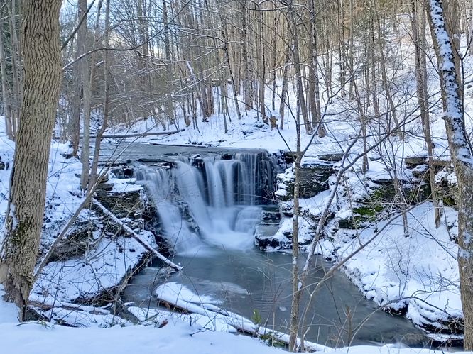
Discover the enchanting Templar Falls Trail in Watkins Glen, New York, offering an easy 0.1-mile out-and-back journey to the captivating Templar Falls. This scenic hike promises easy access to the stunning 18-foot tall two-tiered waterfall, a hidden gem waiting to be explored.

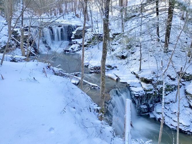
Starting along Templar Road, just where the Finger Lakes Trail (FLT) intersects, adventurers will embark on a gentle descent along the yellow-blazed Finger Lakes Trail. The trail leads to the upper section of Templar Falls (Upper Templar Falls), where hikers can marvel at its majestic cascade from atop the gorge's cliffs. To fully immerse in the natural beauty, venture off-trail into the woods for a short distance downstream, where breathtaking viewpoints await. Here, you'll encounter the mesmerizing sight of Upper Templar Falls gracefully cascading down the gorge's bedrock, standing at an impressive height of approximately 10 feet. Continue your exploration a little further to discover Lower Templar Falls, an additional cascade boasting a height of about 8 feet. Together, these two cascades form the magnificent ~18-foot tall Templar Falls, a spectacle to behold.

After soaking in the splendor of the waterfalls, hikers can retrace their steps back to the parking turnout for a leisurely 0.1-mile out-and-back stroll.

Obstructed Views
Hikers may have a difficult time viewing Templar Falls unless the leaves are off of the trees as most of the viewpoints are located downstream and behind a handful of branches.

Parking
Hikers will find a very small parking turnout at the coordinates provided, located on the North side of Templar Road. The turnout is large enough to fit no more than 2 vehicles as of January 2024. Be mindful of the traffic and make sure your car is pulled off the road to ensure enough room for cars to pass.

Pets
Dogs are allowed only if leashed and must be cleaned up after.

Warning
Steep cliffs: This hike follows steep cliffs that have 10 to 18-foot drops into the gorge below. Watch your step and stay away from the edge for your own safety.

Explore 83 trails near Watkins Glen, NY
  1. Parking

    42.368549, -76.958116
  2. Main Trailhead

    42.368549, -76.958116
  3. Upper Templar Falls, approx. 10-feet tall

    42.368731, -76.958349
    Upper Templar Falls, approx. 10-feet tall
  4. Templar Falls (18-feet tall total)

    42.368787, -76.958346
    Templar Falls (18-feet tall total)
No community routes found. To add your own hike as a Community Route for this Trail guide, leave a Trip Report with an attached GPX file.

Hazards

Ticks - Lyme Disease More Info (CDC)
Poison Ivy/Oak
Rockfalls / Ledges / or Scrambles

Seasons

All

Photo Albums

2 Trip Reports

No Star-Ratings
Write-up by:
Admin user profile picture
0.1 miles / 0.2 km
Trail added
January 14, 2024
Hiked on
January 14, 2024
Updated on
February 12, 2024
0.1 miles / 0.2 km
January 14, 2024
Very short walk. Nice waterfalls
Dogs Hiking

Weather Forecast

In Watkins Glen, NY

Explore Hiking Trails

New Hikes

Lower Ammonoosuc Falls Trail
1.1 Miles
1.8 km
Easy
Out-and-Back
Bates Ferry Trail and General Greene Tree
2.7 Miles
4.3 km
Easy
Out-and-Back
Raven Rocks via Appalachian Trail
5.1 Miles
8.2 km
Strenuous
Out-and-Back
Larry's Creek Trail
3.6 Miles
5.8 km
Moderate
Out-and-Back

Before you leave...

MyHikes is an indie web platform aimed to make exploring public trails easier for everyone. The site has no investors and is owned and operated by one person, Dave Miller (Founder & Admin). As the Founder, main contributor, and doer-of-all-things for MyHikes, I share my trips with over-detailed write-ups for fun on a volunteer basis and I believe that public trail information should be available to everyone.

It takes a lot of time 🕦, money 💰, and effort (including espresso shots ☕) to run MyHikes, including hiking , mapping , writing , and publishing new trails with high-quality content... along with building new features, moderating, site maintainance, and app development for iOS and Android . I simply ask that if you find MyHikes' trail guides helpful to please consider becoming a Supporter to help keep the site, iOS, and Android apps available to everyone.

Supporters unlock website and in-app perks with a one-time payment of $25 (you renew) 😎👍. Or you can simply make a Donation of your choice without a MyHikes user account. Otherwise, telling your friends about MyHikes is the next-best thing - both quick and free 🎉

Thanks for visiting MyHikes and have a great hike!️

Admin user profile picture

Dave Miller
MyHikes Founder & Admin