The Taylor Creek Trail at Zion National Park new New Harmony, Utah is a moderate 5.3-mile out-and-back hike that leads to a Double Arch Alcove features two homesteads from the 1930s, two small waterfalls, and beautiful scenery.
Hike Description
This hike begins at the main trailhead for the Taylor Creek Trail, located at the parking coordinates provided, and heads in on the trail as it makes its way eastward. The trail begins by following a series of stairs down to the Middle Fork Taylor Creek where hikers will start their journey along the creek.
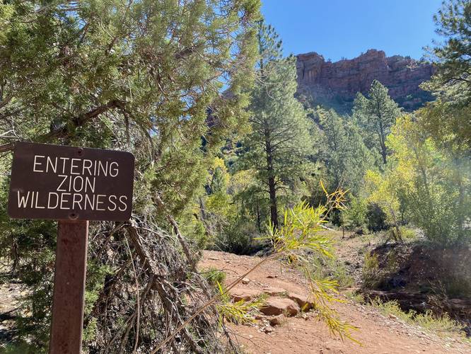
Entering Zion Wilderness - Mile 0.25
At mile 0.25 is a sign labeled "Entering Zion Wilderness" - hikers are truly in the wild now and the hike becomes more scenic from here.
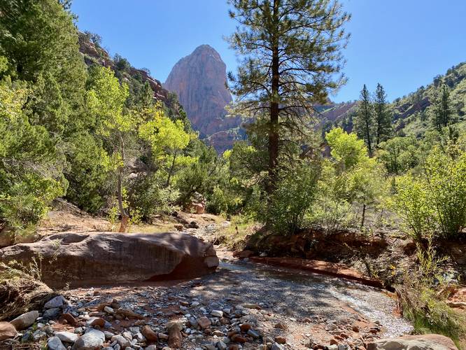
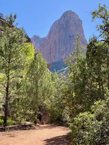
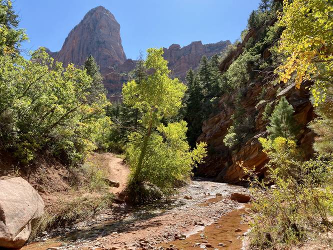
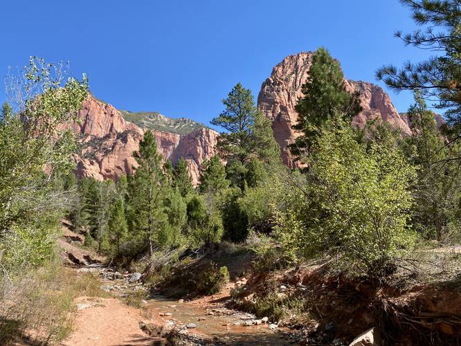
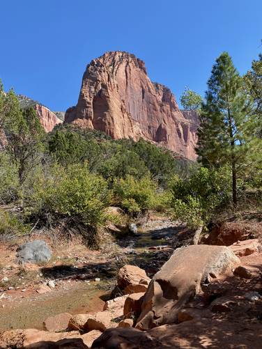
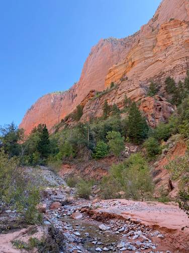
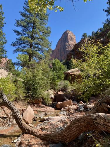
Creek / Rock Spire Views - Mile 0.6 to 1
From miles 0.6 to ~1, hikers will be crossing the creek several times but the area is open enough to provide upstream views of the canyon that the trail passes through - this area is one of the more scenic along the hike. Be sure to take in the scenery as you make your way across and up the creek.
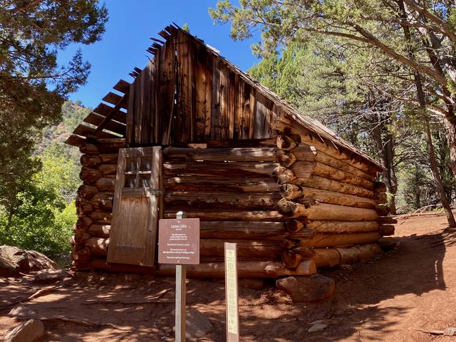
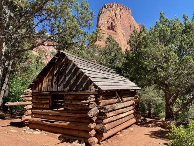
Larson Cabin (Homestead) - Mile 1.15
At mile 1.15, hikers will reach the old homestead cabin named the Larson Cabin. This old homestead was built in ~1930 and served as a pioneer's home in the canyon. It's hard to imagine living virtually alone in a place like this, but it's amazing the cabin still stands today. Be sure to take only photos and stay out of the cabin! After visiting the cabin, the trail goes back to a mix of wooded and shaded areas along with views of the creek and surrounding rock cliffs.
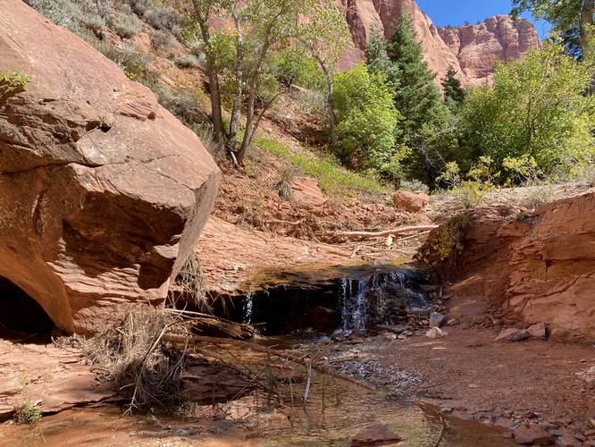
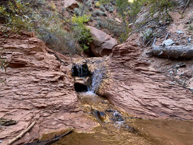
Small Waterfalls - Mile 1.7
Around mile 1.7, hikers will reach a creek crossing where you'll find two very small waterfalls. The waterfall located downstream is approximately 3 - 4 feet tall -- hikers will be able to view the top of the waterfall unless you walk off-trail. The 2nd waterfall is straight ahead - located next to the trail's continuation along the creek's embankment. This waterfall is about 3-feet tall. Both are very short, but are a nice change of scenery from the creek's mostly-flat terrain.
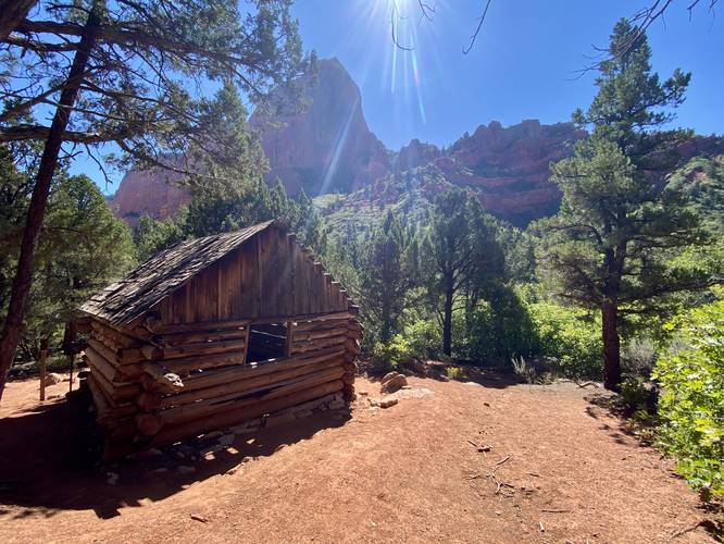
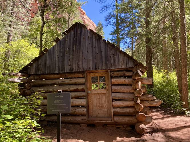
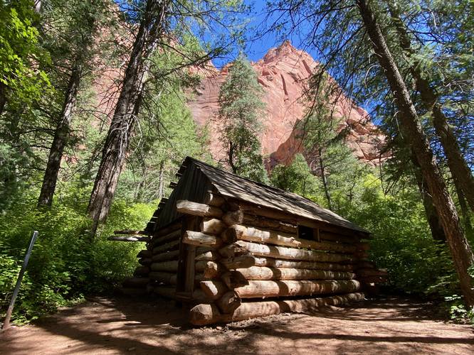
Fife Cabin (Homestead) - Mile 2.2
At mile 2.2, hikers will reach the second homestead along the trail - known as the Fife Cabin. The Fife Cabin was also built circa 1930 and still stands today. Hikers can peer inside to get a better look and idea of what life may have been like living in this cabin. Again, take only photos and do not enter the cabin!
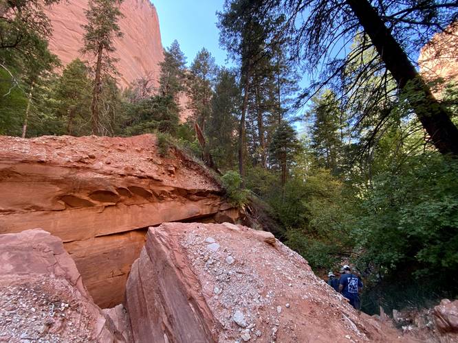
Rockfall Crux - Mile 2.3
At mile 2.3, after hiking through a skinny canyon surrounding the creek, hikers will climb out of that little canyon along a steep rockfall. This rockfall is the crux of the hike and the most-difficult terrain you'll come across on the trail. It's not difficult, but trekking poles help here in addition to going slow. After passing the rockfall, hikers will meander their way along the trail for a short while more before reaching the Double Arch Alcove - along the way hikers will find more scenery of the Taylor Creek canyon.
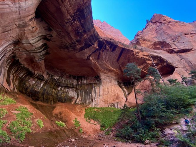
Double Arch Alcove - Mile 2.6
Finally, around mile 2.6, hikers will locate a sign on-trail labeled "Double Arch Alcove" with an arrow. Follow the trail as it leads through some thick underbrush to reach the massive Double Arch Alcove. The Double Arch Alcove is a massive open area where the cliff side has been carved out to form two bowls or two arches deep in the cliff face. This area is so large that it's difficult for the mind to comprehend - the photos do absolutely no justice in capturing the size of this place. While at the Double Arch Alcove, hikers can hang out to enjoy drinks and food to regain energy for the hike back. Be sure to take photos before heading out.
Hiking Out - Mile 2.6 to 5.3
Obviously the hike out follows the same trail in the opposite direction, however the best thing to note here are the creek crossings. As stated in the warnings, there are ~102 creek crossings on this hike if you do the full 5.3 miles, so the hike out includes ~56 creek crossings. Hikers will pass the rockfall crux once more and considering you may never return here, you can enjoy the old cabin homesteads on the way out too. Note that the views of the trail are best when hiking in, so the hike out is slightly-less scenic (unless you turn around frequently). Last, the only difficult part of the hike out is the staircase that leads up and out from the creek and up to the parking lot.
Parking
Hikers will find parking at the coordinates provided along Kolob Canyons Road. Note that the parking lot is large enough to fit about 2 dozen vehicles max. There is no nearby overflow parking; however, there are some parking lots located up the road along Kolob Canyons Road where hikers can hike back to the trailhead if they wish (adding at least a 0.5-mile to the hike). The parking lot fills up quickly so arriving early helps ensure you can get a parking spot.
Popularity
This is a very popular day hike at Zion National Park and you'll likely run into other hikers while on the trail.
Pets
Dogs are not allowed on this trail. Please check Zion National Park's main website to see where dogs are allowed in the park.
Fees
Zion National Park has a $35/week entry fee as of September 2023. Visitors are highly encouraged to purchase an annual National Parks pass before their trip to reduce entry fees (especially if you're passing through multiple parks) and to also speed-up the insanely-long line that leads into the park.
Warnings
Flash floods: This trail follows the Middle Fork Taylor Creek which is known to flash flood. It's best to only hike this trail if you're aware of the local weather forecast and to always avoid the trail when rain is predicted upstream.
Mountain lions: This trail is known to have mountain lions frequent and visit the area. It's smart to not hike alone for this reason and to make your presence known while on the trail to help scare off any potential mountain lions.
Sun exposure: While this trail has plenty of shade, hikers are still exposed to the sun for a long period of time while hiking the 5.3-miles. Be sure to bring proper sun protection.
Creek crossings: There are ~56 creek crossings one-way to reach the Double Arch Alcove, which means hikers will cross the creek ~102 times along this out-and-back hike. During our hike here in late September 2023, the water level was low which made it easy to keep your feet dry.
Hike Description
This hike begins at the main trailhead for the Taylor Creek Trail, located at the parking coordinates provided, and heads in on the trail as it makes its way eastward. The trail begins by following a series of stairs down to the Middle Fork Taylor Creek where hikers will start their journey along the creek.
Entering Zion Wilderness - Mile 0.25
At mile 0.25 is a sign labeled "Entering Zion Wilderness" - hikers are truly in the wild now and the hike becomes more scenic from here.
Creek / Rock Spire Views - Mile 0.6 to 1
From miles 0.6 to ~1, hikers will be crossing the creek several times but the area is open enough to provide upstream views of the canyon that the trail passes through - this area is one of the more scenic along the hike. Be sure to take in the scenery as you make your way across and up the creek.
Larson Cabin (Homestead) - Mile 1.15
At mile 1.15, hikers will reach the old homestead cabin named the Larson Cabin. This old homestead was built in ~1930 and served as a pioneer's home in the canyon. It's hard to imagine living virtually alone in a place like this, but it's amazing the cabin still stands today. Be sure to take only photos and stay out of the cabin! After visiting the cabin, the trail goes back to a mix of wooded and shaded areas along with views of the creek and surrounding rock cliffs.
Small Waterfalls - Mile 1.7
Around mile 1.7, hikers will reach a creek crossing where you'll find two very small waterfalls. The waterfall located downstream is approximately 3 - 4 feet tall -- hikers will be able to view the top of the waterfall unless you walk off-trail. The 2nd waterfall is straight ahead - located next to the trail's continuation along the creek's embankment. This waterfall is about 3-feet tall. Both are very short, but are a nice change of scenery from the creek's mostly-flat terrain.
Fife Cabin (Homestead) - Mile 2.2
At mile 2.2, hikers will reach the second homestead along the trail - known as the Fife Cabin. The Fife Cabin was also built circa 1930 and still stands today. Hikers can peer inside to get a better look and idea of what life may have been like living in this cabin. Again, take only photos and do not enter the cabin!
Rockfall Crux - Mile 2.3
At mile 2.3, after hiking through a skinny canyon surrounding the creek, hikers will climb out of that little canyon along a steep rockfall. This rockfall is the crux of the hike and the most-difficult terrain you'll come across on the trail. It's not difficult, but trekking poles help here in addition to going slow. After passing the rockfall, hikers will meander their way along the trail for a short while more before reaching the Double Arch Alcove - along the way hikers will find more scenery of the Taylor Creek canyon.
Double Arch Alcove - Mile 2.6
Finally, around mile 2.6, hikers will locate a sign on-trail labeled "Double Arch Alcove" with an arrow. Follow the trail as it leads through some thick underbrush to reach the massive Double Arch Alcove. The Double Arch Alcove is a massive open area where the cliff side has been carved out to form two bowls or two arches deep in the cliff face. This area is so large that it's difficult for the mind to comprehend - the photos do absolutely no justice in capturing the size of this place. While at the Double Arch Alcove, hikers can hang out to enjoy drinks and food to regain energy for the hike back. Be sure to take photos before heading out.
Hiking Out - Mile 2.6 to 5.3
Obviously the hike out follows the same trail in the opposite direction, however the best thing to note here are the creek crossings. As stated in the warnings, there are ~102 creek crossings on this hike if you do the full 5.3 miles, so the hike out includes ~56 creek crossings. Hikers will pass the rockfall crux once more and considering you may never return here, you can enjoy the old cabin homesteads on the way out too. Note that the views of the trail are best when hiking in, so the hike out is slightly-less scenic (unless you turn around frequently). Last, the only difficult part of the hike out is the staircase that leads up and out from the creek and up to the parking lot.
Parking
Hikers will find parking at the coordinates provided along Kolob Canyons Road. Note that the parking lot is large enough to fit about 2 dozen vehicles max. There is no nearby overflow parking; however, there are some parking lots located up the road along Kolob Canyons Road where hikers can hike back to the trailhead if they wish (adding at least a 0.5-mile to the hike). The parking lot fills up quickly so arriving early helps ensure you can get a parking spot.
Popularity
This is a very popular day hike at Zion National Park and you'll likely run into other hikers while on the trail.
Pets
Dogs are not allowed on this trail. Please check Zion National Park's main website to see where dogs are allowed in the park.
Fees
Zion National Park has a $35/week entry fee as of September 2023. Visitors are highly encouraged to purchase an annual National Parks pass before their trip to reduce entry fees (especially if you're passing through multiple parks) and to also speed-up the insanely-long line that leads into the park.
Warnings
Flash floods: This trail follows the Middle Fork Taylor Creek which is known to flash flood. It's best to only hike this trail if you're aware of the local weather forecast and to always avoid the trail when rain is predicted upstream.
Mountain lions: This trail is known to have mountain lions frequent and visit the area. It's smart to not hike alone for this reason and to make your presence known while on the trail to help scare off any potential mountain lions.
Sun exposure: While this trail has plenty of shade, hikers are still exposed to the sun for a long period of time while hiking the 5.3-miles. Be sure to bring proper sun protection.
Creek crossings: There are ~56 creek crossings one-way to reach the Double Arch Alcove, which means hikers will cross the creek ~102 times along this out-and-back hike. During our hike here in late September 2023, the water level was low which made it easy to keep your feet dry.