Loading...

WINTER SALE! 50% OFF Supporter Accounts — now through January 31st. Learn More.

Table Falls

Table Falls in the Quehanna Wild Area near Driftwood, Pennsylvania is an easy 0.1-mile out-and-back trail that leads down to the scenic 5-foot waterfall, Table Falls.

This short trail can be somewhat steep and full of roots, but the descent to Table Falls is short and easy, just watch your step.

Once you reach Table Falls, the trail will head down the creek slightly to give hikers a better view of the waterfall. Follow the yellow blazes and stay along the creek to find Table Falls.

Table Falls
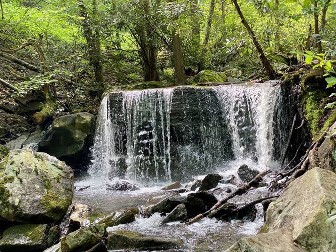
Table Falls is approximately 5-feet tall and has a free fall cascade that spills down into the creek below. While the waterfall is not very big, it's a scenic and popular attraction for the Quehanna Wild Area.

Parking
Hikers will find a small parking turnout on the right-hand side of Red Run Road.

Pets
Dogs are allowed if leashed.
Explore 53 trails near Driftwood, PA

Know Before You Go

  • Table Falls is a small, scenic 5-foot waterfall in the Quehanna Wild Area, accessible via an easy 0.1-mile trail.
  • The trail to Table Falls is short but can be steep and root-filled, requiring careful footing.
  • Dogs are allowed on the trail if kept on a leash.
Interactive topographic map for Table Falls located in Driftwood, PA. Click the "View Map" button to load GPS coordinates and trail markers.
Get directions
Distance
0.1 mi
Difficulty
Easy
Type
Out-and-Back
Est. Time
5 min
Elev. Gain
22'
Rating
4.0
Added
June 02, 2020
Updated
June 03, 2020

Weather Forecast

Loading...
Total Change
22'
Ascent
22'
Descent
22'
Loading...

Download the GPX Data for Offline Use

Supporters get exclusive access to download trail routes to the MyHikes app for offline use. Stay prepared on your adventure, even without an internet connection! Become a Supporter today to unlock this feature and hike with confidence.

Download Table Falls GPX Data to the MyHikes Mobile App

Features

Dogs
Waterfalls
Water Source
PA Wilds logo PA Wilds

Points of interest

  1. Parking

    41.270774, -78.247576
  2. Main Trailhead

    41.270654, -78.247534

Safety information

For your own safety: plan ahead, let someone know where you'll be, and hike at your own risk.

Hazards

Poison Ivy or Poison Oak

Markers

Blaze Color

Yellow

Availability

All seasons

Surface type

Dirt

Trip Reports (Reviews)

Rated 4.0 out of 5 based on 1 rating.

Ready to help fellow hikers? Add a trip report to share your experience and provide valuable insights for other hikers!

No community routes found. To add your own hike as a Community Route for this Trail guide, leave a Trip Report with an attached GPX file.

Popular categories

Scenic mountain view representing vista trails
Vista trails
Scenic gorge of cascades representing waterfall trails
Waterfall hikes
Rugged mountain terrain representing summit trails
Summit trails
Scenic mountain view representing dog-friendly trails
Dog-friendly
Scenic campsite with a view representing camping trails
Camping trails
Appalachian Trail logo representing A.T. hikes
A.T. hikes

You May Also Like

New York's Best Waterfalls - Whether you're planning a day hike, roadside stop, or a leisurely short walk, this guide provides hikers, travelers, and locals alike with 63 different locations to over 100 scenic waterfalls to help plan your next adventure!
Explore

New York's Best Waterfalls

Whether you're planning a day hike, roadside stop, or a leisurely short walk, this guide provides hikers, travelers, and locals alike with 63 different locations to over 100 scenic waterfalls to help plan your next adventure!

Read
🍪 We use cookies to learn about site usage and to serve map tiles. You may block cookies manually in the browser. By continuing you agree. Learn more