Loading...

WINTER SALE! 50% OFF Supporter Accounts — now through January 31st. Learn More.

Sydenham Lookout

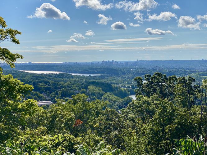
Sydenham Lookout in Hamilton, Ontario is a universally-accessible overlook of the city.

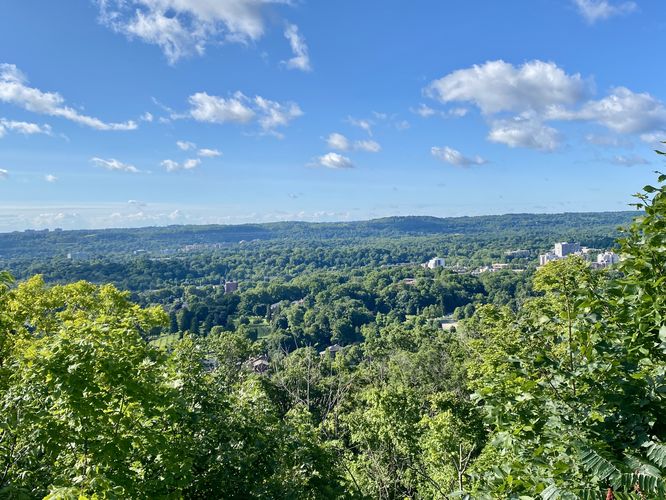
The Sydenham Lookout is not a hike but rather a very short roadside walk that leads to a viewpoint high above Hamilton, Ontario with a view of the city from cliffs along the Niagara Escarpment. Views to the south and southwest are that of the Dundas neighborhood while views southeast and east face downtown Hamilton.

Universal Access
This paved lookout is universally accessible for all visitors.

Parking
Visitors will find a large paved parking area directly at the lookout point at the coordinates provided, located on the south side of Sydenham Road in Hamilton.
Explore 14 trails near Hamilton, ON

Know Before You Go

  • Sydenham Lookout is a universally accessible viewpoint in Hamilton, Ontario, offering panoramic views of the city and surrounding areas like Dundas.
  • It's not a hike but a short, paved roadside walk suitable for all visitors.
  • A large, paved parking area is conveniently located directly at the lookout point on Sydenham Road.
Interactive topographic map for Sydenham Lookout located in Hamilton, Ontario - Canada. Click the "View Map" button to load GPS coordinates and trail markers.
Get directions
Distance
N / A
Difficulty
Easy
Type
Out-and-Back
Est. Time
5 min
Elev. Gain
0m
Rating
0.0
Added
August 11, 2024
Updated
August 27, 2024
Loading...

Features

Vista / Lookout Point
Dogs

Points of interest

  1. Parking

    43.27771, -79.94972
  2. Main Trailhead

    43.277721, -79.949684

Safety information

For your own safety: plan ahead, let someone know where you'll be, and hike at your own risk.

Hazards

Rockfalls, Ledges, or Scrambles

Availability

All seasons

Surface type

Universal Access

Trip Reports (Reviews)

Your opinion matters! Be the first to rate this trail.

Ready to help fellow hikers? Add a trip report to share your experience and provide valuable insights for other hikers!

0 miles / 0 km
August 11, 2024
Hiking
No community routes found. To add your own hike as a Community Route for this Trail guide, leave a Trip Report with an attached GPX file.

Popular categories

Scenic mountain view representing vista trails
Vista trails
Scenic gorge of cascades representing waterfall trails
Waterfall hikes
Rugged mountain terrain representing summit trails
Summit trails
Scenic mountain view representing dog-friendly trails
Dog-friendly
Scenic campsite with a view representing camping trails
Camping trails
Appalachian Trail logo representing A.T. hikes
A.T. hikes

You May Also Like

Colorado's Million Dollar Highway - Plan a day's drive adventure along the iconic Million Dollar Highway in Colorado. Explore the best short trails, roadside stops, waterfalls, vistas, ghost towns, and hot springs within a ~6 hour road trip.
Explore

Colorado's Million Dollar Highway

Plan a day's drive adventure along the iconic Million Dollar Highway in Colorado. Explore the best short trails, roadside stops, waterfalls, vistas, ghost towns, and hot springs within a ~6 hour road trip.

Read
Glacier's Going-to-the-Sun Road - Discover the breathtaking beauty of Glacier National Park along the iconic Going-to-the-Sun Road. From stunning roadside stops to picturesque waterfalls and vistas, this engineering marvel offers endless opportunities for exploration.
Explore

Glacier's Going-to-the-Sun Road

Discover the breathtaking beauty of Glacier National Park along the iconic Going-to-the-Sun Road. From stunning roadside stops to picturesque waterfalls and vistas, this engineering marvel offers endless opportunities for exploration.

Read
🍪 We use cookies to learn about site usage and to serve map tiles. You may block cookies manually in the browser. By continuing you agree. Learn more