Sweet Arrow Falls at Sweet Arrow Lake County Park in Pine Grove, Pennsylvania is an easy universally-accessible 0.4-mile walk that leads to the scenic 12-foot tall waterfall, Sweet Arrow Falls.
Trails
This walk follows one named trail: Waterfall Trail.
Partial Universal Access
Note that this walk is universally accessible from the parking lot through the footbridge that crosses the creek above Sweet Arrow Falls. The path leading from the footbridge to the downstream views of the waterfall is not universally accessible.
Walk Description
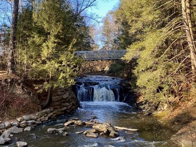
This walk begins at the main trailhead for Sweet Arrow Falls' Waterfall Trail and follows the paved pathway that runs behind the Sweet Arrow Lake dam. The trail then ascends from the back of the dam and leads up to an evergreen forest where walkers will find a footbridge.
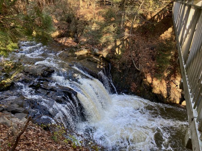
Sweet Arrow Falls - Mile 0.12
At mile 0.12, walkers will begin to cross the footbridge, which provides views of Sweet Arrow Falls below. The waterfall is about 12-feet tall and approximately 20-feet wide. The view from above is a bit deceiving since it's difficult to tell how large the waterfall is. Nonetheless, this is a beautiful spot to take a break and view Sweet Arrow Falls and the evergreens that surround Upper Swatara Creek.
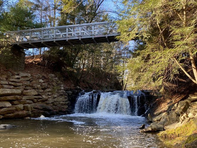
Downstream view of Sweet Arrow Falls - Mile 0.16 to 0.18
After the footbridge, you can walk down the dirt path by taking a right-hand turn. This path will lead to downstream views of Sweet Arrow Falls. The best views are from the creek's edge, closer to the waterfall, however, it's a bit tricky getting there. Hikers will have to traverse rocks to find themselves on the edge of the creek with deep pools below and wet rocks. Watch your step if you plan to get closed to the base of the waterfall. Regardless, the downstream views of Sweet Arrow Falls are much better than the view from the footbridge so it's worth walking around to this point to check it out before leaving.
Parking
Visitors will find parking at the coordinates provided, located on the East side of Waterfall Road in Pine Grove, PA. The lot is large enough to fit just over a dozen vehicles.
Restrooms
As of November 2023, there were non-flush toilets at the parking lot.
Pets
Dogs are allowed if leashed and must be cleaned up after.
Trails
This walk follows one named trail: Waterfall Trail.
Partial Universal Access
Note that this walk is universally accessible from the parking lot through the footbridge that crosses the creek above Sweet Arrow Falls. The path leading from the footbridge to the downstream views of the waterfall is not universally accessible.
Walk Description
This walk begins at the main trailhead for Sweet Arrow Falls' Waterfall Trail and follows the paved pathway that runs behind the Sweet Arrow Lake dam. The trail then ascends from the back of the dam and leads up to an evergreen forest where walkers will find a footbridge.
Sweet Arrow Falls - Mile 0.12
At mile 0.12, walkers will begin to cross the footbridge, which provides views of Sweet Arrow Falls below. The waterfall is about 12-feet tall and approximately 20-feet wide. The view from above is a bit deceiving since it's difficult to tell how large the waterfall is. Nonetheless, this is a beautiful spot to take a break and view Sweet Arrow Falls and the evergreens that surround Upper Swatara Creek.
Downstream view of Sweet Arrow Falls - Mile 0.16 to 0.18
After the footbridge, you can walk down the dirt path by taking a right-hand turn. This path will lead to downstream views of Sweet Arrow Falls. The best views are from the creek's edge, closer to the waterfall, however, it's a bit tricky getting there. Hikers will have to traverse rocks to find themselves on the edge of the creek with deep pools below and wet rocks. Watch your step if you plan to get closed to the base of the waterfall. Regardless, the downstream views of Sweet Arrow Falls are much better than the view from the footbridge so it's worth walking around to this point to check it out before leaving.
Parking
Visitors will find parking at the coordinates provided, located on the East side of Waterfall Road in Pine Grove, PA. The lot is large enough to fit just over a dozen vehicles.
Restrooms
As of November 2023, there were non-flush toilets at the parking lot.
Pets
Dogs are allowed if leashed and must be cleaned up after.