The Sunset Ledge and Goat Roak hike at F. Gilbert Hills State Forest in Wrentham, Massachusetts is an easy 1-mile loop hike that features views from Sunset Ledge and includes a unique bedrock landscape with massive rocks and ledges named Goat Roak.
Hike Description
This hike begins at the main parking lot for F. Gilbert Hills State Forest's High Rock Area - located at the coordinates provided, directly across from SEMRECC at the end of High Rock Road. The trail begins adjacent to the big brown gate - take a right-hand turn at the big gate and then hike straight, heading due-south. Hikers will pass the white blazes of the Warner Trail's northern trailhead immediately on their left while heading south. Pass this junction, but take a left-hand turn at the next junction. From there you'll hike south toward the CCC stone staircase.
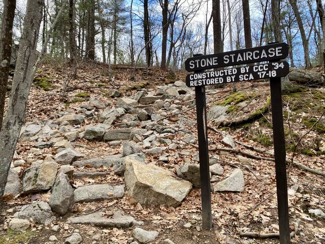
CCC Stone Staircase - Mile 0.35
Around mile 0.35 is an old stone staircase that was constructed by the CCC in 1934 and was restored by SCA in 2017-2018. Hike up (or around if you wish) the CCC staircase to reach the top of the hill. Near the staircase is a series of rock ledges, no more than 10-feet tall, that run a good portion of the hillside's length through the woods here as well.
Right-Hand Turn After CCC Stairs, Then Left Turn
Just after the CCC staircase is a trail junction about 20-feet down the trail. Here, take a right-hand turn to head toward Sunset Ledge (stay on the Warner Trail). Just after this junction is yet another junction - stay left at that one to reach Sunset Ledge.
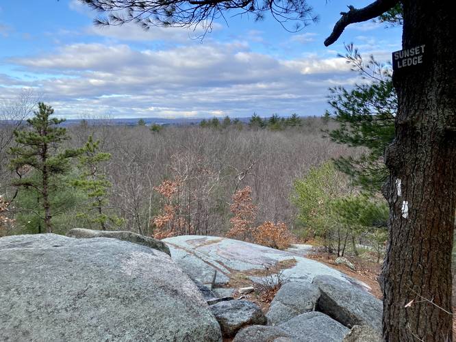
Sunset Ledge - Mile 0.5
Around mile 0.5, hikers will reach Sunset Ledge, which provides views of the tops of the neighboring hills. Most of the view that you get from Sunset Ledge is of a plateau, so you aren't necessarily overlooking much, but it's still a beautiful spot to take in a sunrise, sunset (obviously), or simply chill out on a longer day hike here.
After visiting Sunset Ledge and hanging out for a bit, hikers will want to make their way to Goat Rock before reaching the parking lot. To hike to Goat Rock, head back to the CCC Staircase and instead take a right-hand turn on the Warner Trail. The Warner Trail will lead back to the parking lot, but first it'll make a couple of stops at the massive bedrock outcropping known as Goat Rock.
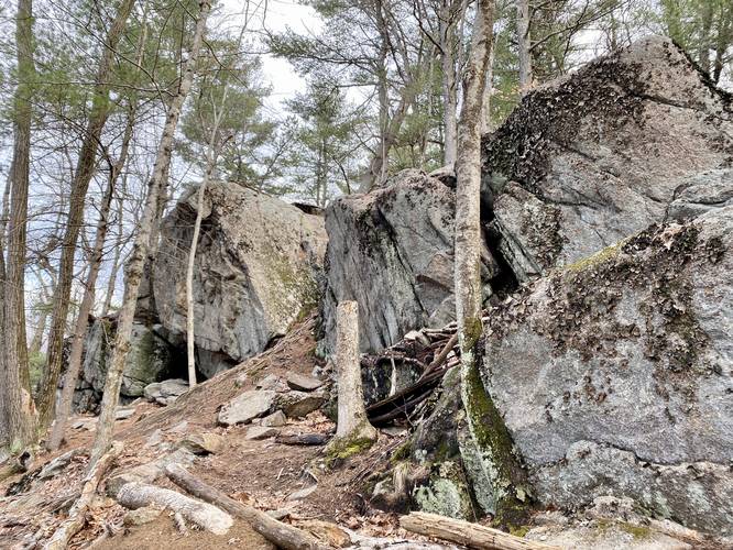
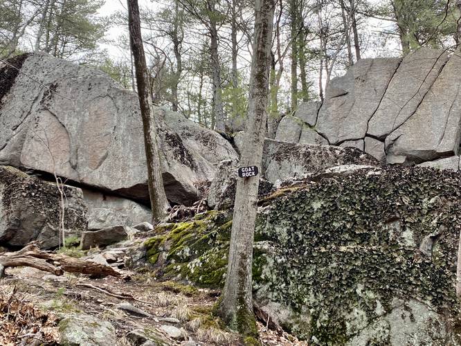
Goat Rock - Mile 0.75 to 0.85
From mile 0.75 to about 0.85, the trail runs alongside the massive bedrock outcropping known as Goat Rock. The rock's ledges tower over the trail - some as high as 30-feet. Goat Rock appears to be a great spot for local climbers to practice or try their hand at new routes along these large rock ledges. For me, these rocks were unexpected, which made for a spectacular hike after visiting Sunset Ledge.
After visiting Goat Rock, the Warner Trail will lead back to almost exactly where you hopped on the trail near the trailhead, making for a 1-mile loop hike.
Parking
Hikers will find a medium-sized parking lot at the coordinates provided at the end of High Rock Road. The lot is large enough to fit a dozen vehicles or slightly less.
Pets
Dogs are allowed if leashed and must be cleaned up after.
Biking
Biking is not allowed on this route, from the looks of the state forest map.
Hike Description
This hike begins at the main parking lot for F. Gilbert Hills State Forest's High Rock Area - located at the coordinates provided, directly across from SEMRECC at the end of High Rock Road. The trail begins adjacent to the big brown gate - take a right-hand turn at the big gate and then hike straight, heading due-south. Hikers will pass the white blazes of the Warner Trail's northern trailhead immediately on their left while heading south. Pass this junction, but take a left-hand turn at the next junction. From there you'll hike south toward the CCC stone staircase.
CCC Stone Staircase - Mile 0.35
Around mile 0.35 is an old stone staircase that was constructed by the CCC in 1934 and was restored by SCA in 2017-2018. Hike up (or around if you wish) the CCC staircase to reach the top of the hill. Near the staircase is a series of rock ledges, no more than 10-feet tall, that run a good portion of the hillside's length through the woods here as well.
Right-Hand Turn After CCC Stairs, Then Left Turn
Just after the CCC staircase is a trail junction about 20-feet down the trail. Here, take a right-hand turn to head toward Sunset Ledge (stay on the Warner Trail). Just after this junction is yet another junction - stay left at that one to reach Sunset Ledge.
Sunset Ledge - Mile 0.5
Around mile 0.5, hikers will reach Sunset Ledge, which provides views of the tops of the neighboring hills. Most of the view that you get from Sunset Ledge is of a plateau, so you aren't necessarily overlooking much, but it's still a beautiful spot to take in a sunrise, sunset (obviously), or simply chill out on a longer day hike here.
After visiting Sunset Ledge and hanging out for a bit, hikers will want to make their way to Goat Rock before reaching the parking lot. To hike to Goat Rock, head back to the CCC Staircase and instead take a right-hand turn on the Warner Trail. The Warner Trail will lead back to the parking lot, but first it'll make a couple of stops at the massive bedrock outcropping known as Goat Rock.
Goat Rock - Mile 0.75 to 0.85
From mile 0.75 to about 0.85, the trail runs alongside the massive bedrock outcropping known as Goat Rock. The rock's ledges tower over the trail - some as high as 30-feet. Goat Rock appears to be a great spot for local climbers to practice or try their hand at new routes along these large rock ledges. For me, these rocks were unexpected, which made for a spectacular hike after visiting Sunset Ledge.
After visiting Goat Rock, the Warner Trail will lead back to almost exactly where you hopped on the trail near the trailhead, making for a 1-mile loop hike.
Parking
Hikers will find a medium-sized parking lot at the coordinates provided at the end of High Rock Road. The lot is large enough to fit a dozen vehicles or slightly less.
Pets
Dogs are allowed if leashed and must be cleaned up after.
Biking
Biking is not allowed on this route, from the looks of the state forest map.