Sunderland Cliff Vista in Sunderland, Massachusetts is an easy 0.5-mile out-and-back hike that leads to views of the 7 Sisters and Holyoke Range, Mt. Tom, and Mt. Sugarloaf.
Hike Description
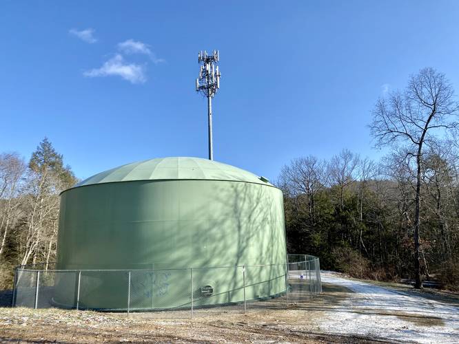
This is a very short hike that most would consider a walk; however, when mapping the Sunderland Cliff in 10-degree weather, we didn't want to go too far, hence the low mileage. Hikers will begin near the gate that leads up to the Sunderland town water supply cistern / tower that sits on the mountainside. Walk past the cistern to find a trail that leads into the woods, the Cliff Trail as labeled on some maps.
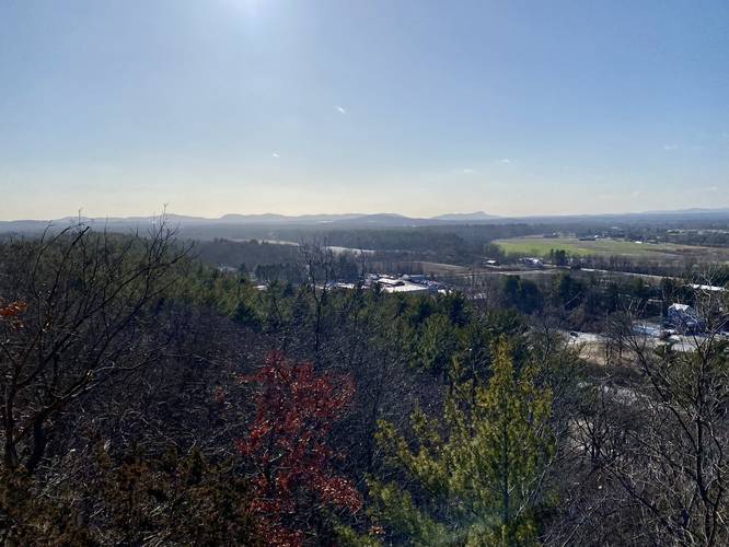
Seasonal View - Mile 0.2
Around mile 0.2, hikers can head off-trail to the edge of the cliff to where you can find a decent view of the 7 Sisters / Holyoke Range and Mt. Tom in the distance with the Sunderland Valley below. Albeit this is more of a seasonal view when the leaves are off of the trees.
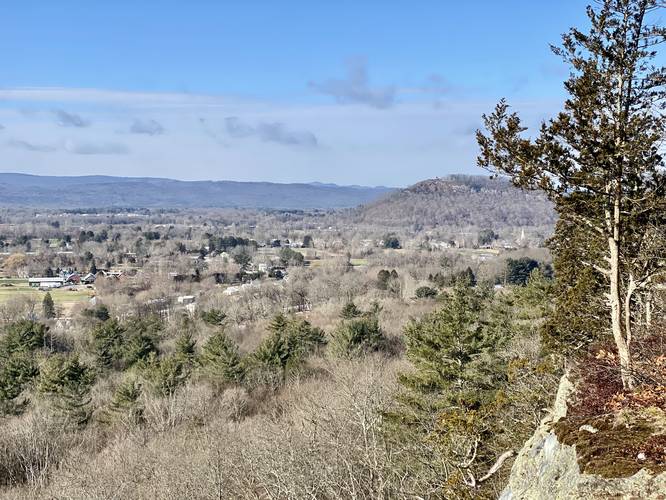
Sunderland Cliff Vista - Mile 0.3
If you hike to the off-trail view, then the better vista aka Sunderland Cliff Vista will be located around mile 0.3. It's located on-trail and difficult to miss. Once at this vista, hikers can once again get views of the 7 Sisters and Mt. Tom to the south, but can also find Mt. Sugarloaf to the north. The entirety of Sunderland Valley sits below your feet at this view and with both mountain ranges on both sides, it makes for a really nice quick hike / walk.
Parking
Hikers will find parking at the end of Clark Mountain Road at the parking turnouts located at the right-hand turn in the road's junction as you approach the top of the mountain. These parking turnouts are fairly small.
Pets
Dogs are allowed if leashed and their waste should be carried out by the hiker.
Biking
Mountain biking may be permitted here.
Warning
Icy road in winter: During the winter and colder months when ice forms on the roads, Clark Mountain Road can be a bit dangerous to drive up without proper winter tires, AWD, or 4WD. The mountain road is not very long (maybe 0.25-miles at most from the last private residence), but it's a one-lane gravel road that passes a very steep mountain hollow. During this visit, there were thick slabs of ice on the road and without proper traction, the ice could send your car plummeting into the hollow below. Drive at your own risk.
Hike Description
This is a very short hike that most would consider a walk; however, when mapping the Sunderland Cliff in 10-degree weather, we didn't want to go too far, hence the low mileage. Hikers will begin near the gate that leads up to the Sunderland town water supply cistern / tower that sits on the mountainside. Walk past the cistern to find a trail that leads into the woods, the Cliff Trail as labeled on some maps.
Seasonal View - Mile 0.2
Around mile 0.2, hikers can head off-trail to the edge of the cliff to where you can find a decent view of the 7 Sisters / Holyoke Range and Mt. Tom in the distance with the Sunderland Valley below. Albeit this is more of a seasonal view when the leaves are off of the trees.
Sunderland Cliff Vista - Mile 0.3
If you hike to the off-trail view, then the better vista aka Sunderland Cliff Vista will be located around mile 0.3. It's located on-trail and difficult to miss. Once at this vista, hikers can once again get views of the 7 Sisters and Mt. Tom to the south, but can also find Mt. Sugarloaf to the north. The entirety of Sunderland Valley sits below your feet at this view and with both mountain ranges on both sides, it makes for a really nice quick hike / walk.
Parking
Hikers will find parking at the end of Clark Mountain Road at the parking turnouts located at the right-hand turn in the road's junction as you approach the top of the mountain. These parking turnouts are fairly small.
Pets
Dogs are allowed if leashed and their waste should be carried out by the hiker.
Biking
Mountain biking may be permitted here.
Warning
Icy road in winter: During the winter and colder months when ice forms on the roads, Clark Mountain Road can be a bit dangerous to drive up without proper winter tires, AWD, or 4WD. The mountain road is not very long (maybe 0.25-miles at most from the last private residence), but it's a one-lane gravel road that passes a very steep mountain hollow. During this visit, there were thick slabs of ice on the road and without proper traction, the ice could send your car plummeting into the hollow below. Drive at your own risk.