Loading...

🎉 Enjoy a Free 7-Day Supporter Trial and Unlock Exclusive Perks — No Credit Card Required. Learn more.

Sullivan Falls

Directions
Map
Pictures
Send to App
Distance:
0.2 Miles / 0.3 km
Type:
Out-and-Back
Difficulty:
Easy
Time to Hike:
~6 minutes
Features:
PA Wilds
Surface Type:
Dirt
Park:
State Game Lands 13
Town:
Benton, Pennsylvania
Directions:
41.334851, -76.339371
Added:
February 04, 2025
Updated:
June 11, 2025
Copy Trail Link Hiking this trail? Send a friend or family member a link to this trail guide for your own safety. Hike at your own risk (disclaimer)
Loading...
Loading...
65'

Total Change
67'

Ascent
67'

Descent

Download the Trail Route for Offline Use

Supporters get exclusive access to download trail routes to the MyHikes app for offline use. Stay prepared on your adventure, even without an internet connection! Become a Supporter today to unlock this feature and hike with confidence.

Send to App

Sullivan Falls

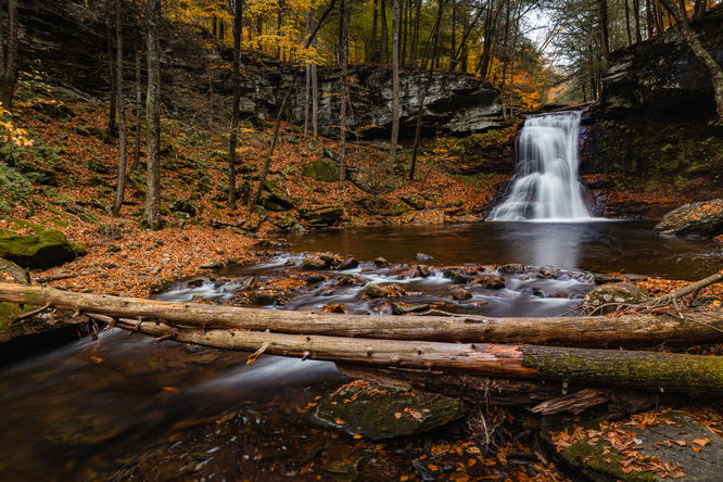
Sullivan Falls in Benton, Pennsylvania is a scenic ~50-foot tall almost-roadside waterfall in Pennsylvania State Game Lands 13. This waterfall can be viewed with just a short 0.1-mile walk following a path from the backside of the parking area and to the top of the waterfall. There is a steep narrow path that descends to the base of the waterfall for further viewing and exploring of the waterfall if you chose to do so, but explore at your own risk.

Difficulty

If you plan to hike to the top of Sullivan Falls, this is an easy mostly-flat hike. If you plan to hike to the base of the waterfall, consider it moderate.

Pets

Dogs are allowed if leashed and cleaned up after.

Parking

The parking for this hike is a large pull off along Sullivan Falls Road which is marked with a large rock labeled 'Sullivan Falls.'  This forest road is not maintained in the winter and access could be limited based on road conditions.

Warning

Steep terrain: Be mindful of the steep ledges and drop-offs near the waterfall. If hiking to the base, the terrain may be steep with loose soil.

Timber rattlesnakes: This area is home to the Timber Rattlesnake which can be found roaming the forest between the months of April and October. Be mindful and if you find any rattlers, give them plenty of space.

Explore 37 trails near Benton, PA
  1. Parking

    41.334851, -76.339371
  2. Main Trailhead

    41.33485, -76.339431
  3. Sullivan Falls (approx. 50-feet tall)

    41.335663, -76.340049
    Sullivan Falls (approx. 50-feet tall)
No community routes found. To add your own hike as a Community Route for this Trail guide, leave a Trip Report with an attached GPX file.

Hazards

Ticks - Lyme Disease More Info (CDC)
Snakes
Poison Ivy/Oak
Rockfalls / Ledges / or Scrambles

Seasons

All

Weather Forecast

In Benton, PA

Explore Hiking Trails

You May Also Like

Colorado's Million Dollar Highway - Plan a day's drive adventure along the iconic Million Dollar Highway in Colorado. Explore the best short trails, roadside stops, waterfalls, vistas, ghost towns, and hot springs within a ~6 hour road trip.
Explore

Colorado's Million Dollar Highway

Plan a day's drive adventure along the iconic Million Dollar Highway in Colorado. Explore the best short trails, roadside stops, waterfalls, vistas, ghost towns, and hot springs within a ~6 hour road trip.

Read
New York's Best Waterfalls - Whether you're planning a day hike, roadside stop, or a leisurely short walk, this guide provides hikers, travelers, and locals alike with 63 different locations to over 100 scenic waterfalls to help plan your next adventure!
Explore

New York's Best Waterfalls

Whether you're planning a day hike, roadside stop, or a leisurely short walk, this guide provides hikers, travelers, and locals alike with 63 different locations to over 100 scenic waterfalls to help plan your next adventure!

Read

Before you boogie...

Find our trail guides useful? Consider becoming a Supporter to unlock perks!

MyHikes is an indie platform that makes exploring public trails easier for everyone. The platform has no investors, no ads, and is owned and operated by one person, Dave Miller. Dave has personally mapped and written over 1,800 trail guides on MyHikes for the public to explore. MyHikes has helped millions outdoor enthusiasts plan their next adventure.

But it takes a lot of time 🕦, money 💰, work, and espresso shots ☕ to run MyHikes, including hiking , mapping , writing , and publishing new trails with high-quality (accurate) information... along with software engineering (coding) the platform like building new features, website and mobile app development (iOS and Android), site maintainance . and much much more.

Supporters unlock website and mobile app perks with an annual one-time payment of $25 (you renew) 😎👍. Or you can simply make a Donation of your choice. Otherwise, you can support us by telling your friends about MyHikes - both quick and free 🎉

Admin user profile picture

Dave Miller
MyHikes Founder