Loading...

🎉 Enjoy a Free 7-Day Supporter Trial and Unlock Exclusive Perks — No Credit Card Required. Learn more.

Sugar Knob Hike

Directions
Map
Pictures
Send to App
Distance:
9.8 Miles / 15.8 km
Type:
Loop
Difficulty:
Moderate
Time to Hike:
4 hours, ~54 minutes
Features:
Surface Type:
Dirt
Park:
George Washington National Forest
Town:
Wardensville, West Virginia
Directions:
39.016167, -78.605425
Added:
February 17, 2025
Updated:
April 05, 2025
Copy Trail Link Hiking this trail? Send a friend or family member a link to this trail guide for your own safety. Hike at your own risk (disclaimer)
Loading...
Loading...
1,620'

Total Change
2,030'

Ascent
2,028'

Descent

Download the Trail Route for Offline Use

Supporters get exclusive access to download trail routes to the MyHikes app for offline use. Stay prepared on your adventure, even without an internet connection! Become a Supporter today to unlock this feature and hike with confidence.

Send to App

Sugar Knob Hike

The Sugar Knob hike up Pond Run Trail and down Racer Camp Hollow Trail has some of the best stream scenery in the George Washington National Forest. This is one of several great loops in the Great North Mountain Area with fantastic camp sites all along its route.

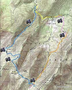
Just before the bridge over Waites Run start the hike up Pond Run Trail. Pond Run Trail is both blue and green blazed (green blazes designate deer study areas and can be found throughout the Great North Mountain region). It will cross the run a number of times as it winds its way up the valley. After 2.5 miles cross a wooden ford placed over wet land area and arrive at the ridge.

At the trail intersection you can make a quick side trip by going directly ahead on the white blazed lookout trail for 100 yards and a great view to the west. Return to the trail and turn right (left if you didn't go to the lookout).

In 0.5 miles the forestry road will turn right uphill, continue straight on the blue blazed trail as it winds around the mountain for 1.3 miles before reaching the intersection of the orange blazed Mill Mountain Trail that continues straight ahead.

Turn left continuing on the blue blazed trail as it descends slightly on its way to Sugar Knob. In 0.6 miles arrive at the four way intersection of the Peer Trail, to your left, and the Stony Creek Trail, to your right.

Continue straight on the blue blazed trail for 0.9 miles as it passes over Sugar Knob then descends continuing to another four way intersection.

Turn left downhill on the orange blazed Racer Camp Hollow Trail as it passes several great camp spots and crosses the run several times before turning right uphill in 1.6 miles.

After climbing uphill for 100 yards the trail will turn left traversing the mountain for another 0.9 miles and reaching the junction of the pink blazed Old Mail Path and wildlife clearing.

Turn left downhill into the clearing and at the bottom of the clearing enter the pink blazed Old Mail Path as it winds downhill before arriving in 1.0 mile at a wooden foot bridge and crossing Waites Run. Continue downstream on the pink blazed trail for another 0.5 miles before arriving at the yellow blazed FS road.

Turn left downhill on the FS road and in 0.4 miles pass a closed gate. Continue downhill on the FS road with Waites Run now on your left for 1.0 mile and crossing a bridge arriving back at the parking area.

Explore 67 trails near Wardensville, WV
  1. Parking

    39.016167, -78.605425
  2. Main Trailhead

    39.015866, -78.605397
No community routes found. To add your own hike as a Community Route for this Trail guide, leave a Trip Report with an attached GPX file.

Hazards

Ticks - Lyme Disease More Info (CDC)
Snakes
Poison Ivy/Oak

Seasons

All

Trip Reports

Trail Guide By:
HikingUpward user profile picture
9.8 miles / 15.8 km

Weather Forecast

In Wardensville, WV

Explore Hiking Trails

You May Also Like

Colorado's Million Dollar Highway - Plan a day's drive adventure along the iconic Million Dollar Highway in Colorado. Explore the best short trails, roadside stops, waterfalls, vistas, ghost towns, and hot springs within a ~6 hour road trip.
Explore

Colorado's Million Dollar Highway

Plan a day's drive adventure along the iconic Million Dollar Highway in Colorado. Explore the best short trails, roadside stops, waterfalls, vistas, ghost towns, and hot springs within a ~6 hour road trip.

Read
New York's Best Waterfalls - Whether you're planning a day hike, roadside stop, or a leisurely short walk, this guide provides hikers, travelers, and locals alike with 63 different locations to over 100 scenic waterfalls to help plan your next adventure!
Explore

New York's Best Waterfalls

Whether you're planning a day hike, roadside stop, or a leisurely short walk, this guide provides hikers, travelers, and locals alike with 63 different locations to over 100 scenic waterfalls to help plan your next adventure!

Read

Before you boogie...

Find our trail guides useful? Consider becoming a Supporter to unlock perks!

MyHikes is an indie platform that makes exploring public trails easier for everyone. The platform has no investors, no ads, and is owned and operated by one person, Dave Miller. Dave has personally mapped and written over 1,800 trail guides on MyHikes for the public to explore. MyHikes has helped millions outdoor enthusiasts plan their next adventure.

But it takes a lot of time 🕦, money 💰, work, and espresso shots ☕ to run MyHikes, including hiking , mapping , writing , and publishing new trails with high-quality (accurate) information... along with software engineering (coding) the platform like building new features, website and mobile app development (iOS and Android), site maintainance . and much much more.

Supporters unlock website and mobile app perks with an annual one-time payment of $25 (you renew) 😎👍. Or you can simply make a Donation of your choice. Otherwise, you can support us by telling your friends about MyHikes - both quick and free 🎉

Admin user profile picture

Dave Miller
MyHikes Founder