Loading...

🎉 Enjoy a Free 7-Day Supporter Trial and Unlock Exclusive Perks — No Credit Card Required. Learn more.

Stony Mountain Hike

Directions
Map
Pictures
Send to App
Distance:
10.2 Miles / 16.4 km
Type:
Loop
Difficulty:
Hard
Time to Hike:
5 hours, ~6 minutes
Features:
Surface Type:
Dirt
Park:
Shenandoah National Park
Town:
Syria, Virginia
Directions:
38.514633, -78.366251
Added:
March 19, 2025
Updated:
April 06, 2025
Copy Trail Link Hiking this trail? Send a friend or family member a link to this trail guide for your own safety. Hike at your own risk (disclaimer)
Loading...
Loading...
1,875'

Total Change
1,926'

Ascent
1,933'

Descent

Download the Trail Route for Offline Use

Supporters get exclusive access to download trail routes to the MyHikes app for offline use. Stay prepared on your adventure, even without an internet connection! Become a Supporter today to unlock this feature and hike with confidence.

Send to App

Stony Mountain Hike

The Stony Mountain circuit is one of the more secluded loops in the SNP. Overshadowed by the more popular Old Rag Mountain and White Oak Canyon hikes just to the north. With great views of the valley from Stony Mountain, and a nice swimming hole on the Rose River, this is one hike worth checking out. 

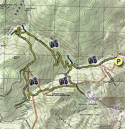
From the parking area head up the yellow blazed Rose River Fire Road passing through a closed gate. Don't be confused by the initial red blazes on the trees, these designate the SNP boundary. Hike up the fire road with Rose River on your right and in 0.5 miles look for a small unmarked trail on your right that leads down to the river and great swimming hole in the summer. In 0.6 miles cross a steel bridge that spans Dark Hollow Creek. Continue up the fire road and pass an unmarked trail on your right.

The fire road now turns left and ascends Stony Mountain. At the first switchback pass the Upper Dark Hollow Trail on your left, this will be your return route. Continue on the fire road and in 100 yards, 30 yards off the trail on the right, there is an old cemetery. The cemetery is no longer maintained. It has 30+ graves with the most recent dating to the 1920's, just prior to when the SNP was established in 1935.

Continue along the yellow blazed fire road as it does four more switchbacks before traversing the mountain and arriving at an unofficial trail and concrete post on the right in 2.3 miles. 0.3 miles further the fire road makes another switchback to the left, then in 0.2 miles arrive at the Stony Mountain Trail junction. Stay straight on the Stony Mountain Trail as the fire road you have been following turns sharply to the right.

Follow the yellow blazed Stony Mountain Trail as it as ascends the mountain. This is the steepest part of the hike and the trail is hard to spot in places. Keep an eye out for the yellow blazes.

From the high point on the trail gently descend for 0.3 miles and arrive at the intersection of the Rapidan Fire Road where the Stony Mountain Trail ends. Turn left downhill on the fire road and look for a rocky mound on the left in 0.4 miles. Climb the mound for the best view of the hike. Continue downhill another 0.4 miles to the intersection of the Upper Dark Hollow Trail where the fire road now veers to the right.

Turn left downhill on the yellow blazed Upper Dark Hollow Trail descending the side of Double Top Mountain. This section of the hike passes through the Rapidan State Wildlife Management Area, and has both red blazes designating the SNP boundary, and yellow blazes for the Upper Dark Hollow Trail. In 1.5 miles the Upper Dark Hollow Trail will turn left downhill. This junction is marked with a 'W' on the right and wooden trail sign on the left. Turn left downhill remaining on the yellow blazed Upper Dark Hollow Trail as it steeply descends for 0.5 miles before crossing Dark Hollow Creek. Continue on the trail for another 0.1 miles where the Upper Dark Hollow Trail ends at the Rose River Fire Road you ascended earlier.

Turn right downhill on the fire road retracing your route over the steel bridge and arriving back at the parking area in 1.1 miles.

Explore 80 trails near Syria, VA
  1. Parking

    38.514633, -78.366251
  2. Main Trailhead

    38.514359, -78.365994
No community routes found. To add your own hike as a Community Route for this Trail guide, leave a Trip Report with an attached GPX file.

Hazards

Ticks - Lyme Disease More Info (CDC)
Snakes
Poison Ivy/Oak

Seasons

All

Blaze Color

Yellow

Trip Reports

Trail Guide By:
HikingUpward user profile picture
10.2 miles / 16.4 km

Weather Forecast

In Syria, VA

Explore Hiking Trails

You May Also Like

New York's Best Waterfalls - Whether you're planning a day hike, roadside stop, or a leisurely short walk, this guide provides hikers, travelers, and locals alike with 63 different locations to over 100 scenic waterfalls to help plan your next adventure!
Explore

New York's Best Waterfalls

Whether you're planning a day hike, roadside stop, or a leisurely short walk, this guide provides hikers, travelers, and locals alike with 63 different locations to over 100 scenic waterfalls to help plan your next adventure!

Read
25 Best Day Hikes in North Carolina - Discover the top 25 best day hikes in North Carolina, from breathtaking waterfalls to mountain peaks. Explore hidden gems, scenic views, and trails suitable for all skill levels, perfect for your next outdoor adventure.
Explore

25 Best Day Hikes in North Carolina

Discover the top 25 best day hikes in North Carolina, from breathtaking waterfalls to mountain peaks. Explore hidden gems, scenic views, and trails suitable for all skill levels, perfect for your next outdoor adventure.

Read

Before you boogie...

Find our trail guides useful? Consider becoming a Supporter to unlock perks!

MyHikes is an indie platform that makes exploring public trails easier for everyone. The platform has no investors, no ads, and is owned and operated by one person, Dave Miller. Dave has personally mapped and written over 1,800 trail guides on MyHikes for the public to explore. MyHikes has helped millions outdoor enthusiasts plan their next adventure.

But it takes a lot of time 🕦, money 💰, work, and espresso shots ☕ to run MyHikes, including hiking , mapping , writing , and publishing new trails with high-quality (accurate) information... along with software engineering (coding) the platform like building new features, website and mobile app development (iOS and Android), site maintainance . and much much more.

Supporters unlock website and mobile app perks with an annual one-time payment of $25 (you renew) 😎👍. Or you can simply make a Donation of your choice. Otherwise, you can support us by telling your friends about MyHikes - both quick and free 🎉

Admin user profile picture

Dave Miller
MyHikes Founder