Loading...

๐ŸŽ‰ Enjoy a Free 7-Day Supporter Trial and Unlock Exclusive Perks โ€” No Credit Card Required. Learn more.

Steedman Woods Trail

Directions
Map
Pictures
Send to App
Distance:
0.3 Miles / 0.5 km
Type:
One-Way
Difficulty:
Easy
Time to Hike:
~9 minutes
Features:
Surface Type:
Dirt
Park:
Steedman Woods
Town:
York, Maine
Directions:
43.137051, -70.647451
Added:
August 05, 2021
Updated:
August 05, 2021
Copy Trail Link Hiking this trail? Send a friend or family member a link to this trail guide for your own safety. Hike at your own risk (disclaimer)
Loading...
Loading...
46'

Total Change
44'

Ascent
25'

Descent

Download the Trail Route for Offline Use

Supporters get exclusive access to download trail routes to the MyHikes app for offline use. Stay prepared on your adventure, even without an internet connection! Become a Supporter today to unlock this feature and hike with confidence.

Send to App

Steedman Woods Trail

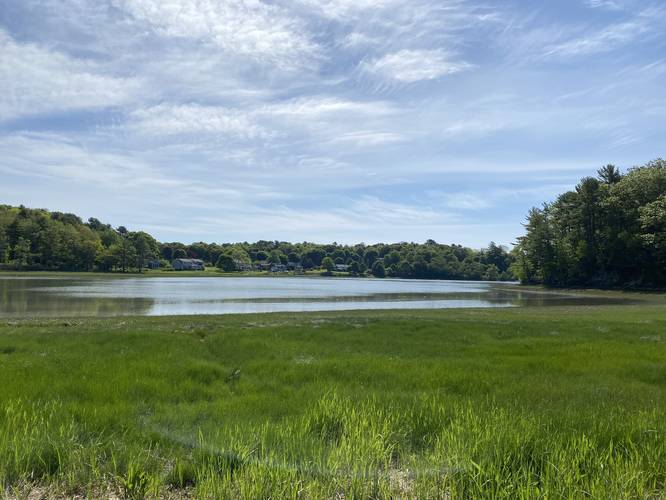
The Steedman Woods Trail at Steedman Woods in York, Maine is an easy 0.3-mile one-way trail that cuts through the northern section of the park and features a small view of a tidal marsh.

This trail has two trailheads located along Mill Dam Road in York. Both are only accessible by foot. There are no blazes along this trail, but it's not difficult to follow. On the official trail map, this trail is labeled the "Secondary Trail".

Parking
Hikers should note that there is no parking located near this trailhead or along Mill Dam Road in York. The only place hikers can park is along Lilac Lane (Route 103) in York. Permit parking takes up most of the parking spaces, but a few non-permit parking spaces can be found there as well, as of Summer 2021.

Pets
Dogs are allowed if leashed and their waste must be carried out.

Poison Ivy
This trail has plenty of poison ivy during the warmer months. Watch your step.
Explore 42 trails near York, ME
  1. Parking

    43.137051, -70.647451
  2. Main Trailhead

    43.137754, -70.653688
  3. Saltwater tidal marsh

    43.138653, -70.653367
    Saltwater tidal marsh
No community routes found. To add your own hike as a Community Route for this Trail guide, leave a Trip Report with an attached GPX file.

Hazards

Ticks - Lyme Disease More Info (CDC)
Poison Ivy/Oak

Seasons

All

Photo Albums

Trip Reports

Trail Guide By:
Admin user profile picture
0.3 miles / 0.5 km

Weather Forecast

In York, ME

Explore Hiking Trails

You May Also Like

Colorado's Million Dollar Highway - Plan a day's drive adventure along the iconic Million Dollar Highway in Colorado. Explore the best short trails, roadside stops, waterfalls, vistas, ghost towns, and hot springs within a ~6 hour road trip.
Explore

Colorado's Million Dollar Highway

Plan a day's drive adventure along the iconic Million Dollar Highway in Colorado. Explore the best short trails, roadside stops, waterfalls, vistas, ghost towns, and hot springs within a ~6 hour road trip.

Read
Glacier's Going-to-the-Sun Road - Discover the breathtaking beauty of Glacier National Park along the iconic Going-to-the-Sun Road. From stunning roadside stops to picturesque waterfalls and vistas, this engineering marvel offers endless opportunities for exploration.
Explore

Glacier's Going-to-the-Sun Road

Discover the breathtaking beauty of Glacier National Park along the iconic Going-to-the-Sun Road. From stunning roadside stops to picturesque waterfalls and vistas, this engineering marvel offers endless opportunities for exploration.

Read
New York's Best Waterfalls - Whether you're planning a day hike, roadside stop, or a leisurely short walk, this guide provides hikers, travelers, and locals alike with 63 different locations to over 100 scenic waterfalls to help plan your next adventure!
Explore

New York's Best Waterfalls

Whether you're planning a day hike, roadside stop, or a leisurely short walk, this guide provides hikers, travelers, and locals alike with 63 different locations to over 100 scenic waterfalls to help plan your next adventure!

Read

Before you boogie...

Find our trail guides useful? Consider becoming a Supporter to unlock perks!

MyHikes is an indie platform that makes exploring public trails easier for everyone. The platform has no investors, no ads, and is owned and operated by one person, Dave Miller. Dave has personally mapped and written over 1,800 trail guides on MyHikes for the public to explore. MyHikes has helped millions outdoor enthusiasts plan their next adventure.

But it takes a lot of time ๐Ÿ•ฆ, money ๐Ÿ’ฐ, work, and espresso shots โ˜• to run MyHikes, including hiking , mapping , writing , and publishing new trails with high-quality (accurate) information... along with software engineering (coding) the platform like building new features, website and mobile app development (iOS and Android), site maintainance . and much much more.

Supporters unlock website and mobile app perks with an annual one-time payment of $25 (you renew) ๐Ÿ˜Ž๐Ÿ‘. Or you can simply make a Donation of your choice. Otherwise, you can support us by telling your friends about MyHikes - both quick and free ๐ŸŽ‰

Admin user profile picture

Dave Miller
MyHikes Founder