Note: The trails in St Mary's Wilderness are no longer blazed.
Both Hikes:
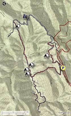
From the parking area,
start down the narrow trail just to the left of the bulletin kiosk (not
the wider road continuing past the closed gate), and walk 150 yards to
the intersection of the Mine Bank Creek and Bald Mountain trails. Turn
left downward on the Mine Bank Creek Trail as it descends into the valley, crossing Mine Creek several times, then passes through a rhododendron area before ending at the intersection for the St. Mary's River Trail in 1.9 miles.
For The Additional 5.5 Mile Out/Back To St. Mary's Falls:
Turn left downstream on the St. Mary's River Trail
passing several campsites before reaching the intersection of the St.
Mary's Falls Trail in 1.9 miles. Note: There is no
camping permitted beyond this point. Turn right upstream fording St.
Mary's River passing several swimming holes before there is a blowout on
the trail in 0.4 miles. Follow the footpath to the left of the blowout
that leads around the blockage back to the trail. At 0.6 miles from the
last intersection the trail appears to end at a cliff about 15ft above
the river. Climb down, re-ford the river, and climb up a steep bank. The falls are just ahead from this point. To continue, retrace your steps back to the intersection of the Mine Bank Creek and St. Mary's River Trails. (Thanks to MRHyker for the St. Mary's Falls trail notes.)
Both Hikes:
If you did the out/back to St. Mary's Falls continue
straight on the St. Mary's River Trail. If you are doing the shorter
hike, turn right onto the St. Mary's River Trail from the Mine Bank
Trail.
Shortly cross a creek before passing a campsite on the left in 0.2 miles. Continue along the trail for another 0.2 miles, cross another creek, then directly ahead over a small mound is a large group camping area. Stay right climbing steeply for 50 yards and pass another campsite before reaching the main St. Mary's River Trail intersection in 0.1 miles.
Turn left (turning right would lead the 0.1 miles back to the stream crossing you just made), and follow the trail as it becomes considerably more overgrown with rhododendron before climbing out of the valley. The trail will level out in 2.0 miles from the last intersection and arrive at the Green Pond area. There is a bulletin board kiosk on the left, and following the small trail on the right leads to a multi-tent camping area. Look for a small trail that leads to Green Pond here.
Return to the bulletin kiosk and continue on the St. Mary's River Trail and pass another pond view on the right in 50 yards, then arrive at what looks like a trail intersection. Continue straight and in 100 yards the trail will veer right. Continue for the remaining 0.1 miles on the St. Mary's River Trail where it ends at Forestry Service (FS) Road 162.
Turn right. Note: FS162 is open to motorized traffic. Be prepared to see 4x4 vehicles and dirt bikes. Follow FS162 for 1.2 miles as it descends then climbs to the high point of Flint Mountain.
150 yards from the high point on FS162 there is a Forestry Service side grade used to clear debris. Look for an unmarked trail on the left that in 100 yards goes to the best vista of the hike. The view is of Kennedy Creek, with Kennedy Ridge on the left, and Kelly Mountain on the right. Return to FS162 and turn left continuing to descend the mountain. Follow the forestry road for another 1.9 miles, passing several campsites with views before arriving at a split in the road.
Stay right and in 0.4 miles, just before FS162 bears left, look for a single post and unmarked trail on the right. This is the Bald Mountain Trail, and is not marked at the junction. Turn right onto the Bald Mountain Trail as it descends the valley and arrives at a small campsite at its low point in 0.9 miles. Continue as it starts climbing back towards the ridge, then arrives at an unmarked trail intersection in 0.9 miles from the campsite.
Stay right for another 0.2 miles back to the intersection of the Mine Bank Creek Trail. Turn left uphill for the remaining 150 yards to the parking area.