Loading...

🍁 Fall is here! Check out our foliage map to plan your autumn hikes! Learn more.

South and North View

Directions
Map
Pictures
Send to App
Distance:
0.2 Miles / 0.3 km
Type:
Out-and-Back
Difficulty:
Easy
Time to Hike:
~6 minutes
Features:
PA Wilds
Surface Type:
Dirt
Park:
Tiadaghton State Forest
Town:
Armstrong Township, Pennsylvania
Get Directions:
41.182254, -76.996623
Added:
October 28, 2023
Updated:
January 02, 2024
Copy Trail Link Hiking this trail? Send a friend or family member a link to this trail guide for your own safety. Hike at your own risk (disclaimer)
Loading...
Loading...
32'

Total Change
53'

Ascent
53'

Descent

Download the Trail Route for Offline Use

Supporters get exclusive access to download trail routes to the MyHikes app for offline use. Stay prepared on your adventure, even without an internet connection! Become a Supporter today to unlock this feature and hike with confidence.

Send to App

Key Takeaways

  • The South and North View trail is an easy 0.2-mile out-and-back walk in Armstrong Township, PA, within Tiadaghton State Forest.
  • The trail offers two mountain views: one of the Maple Hill valley (southward) and another of the Hagerman Reservoir (northward), though power lines may obstruct the views.
  • Parking is available in a small lot along Skyline Drive, and leashed dogs are permitted on the trail with responsible clean-up.

South and North View

South and North View at Tiadaghton State Forest in Armstrong Township, Pennsylvania is an easy 0.2-mile out-and-back walk that features two mountain views, including a view of the Hagerman Reservoir.

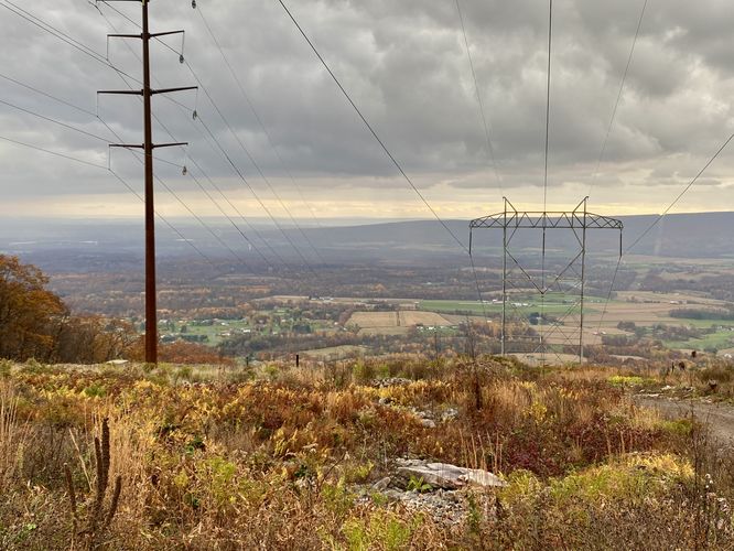
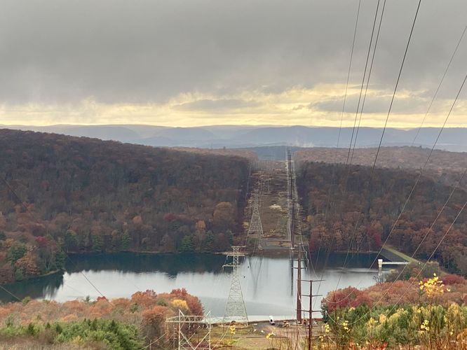
This short walk first leads down the mountain slopes heading southward, following the power lines, just off of Skyline Drive. The trail continues down the mountain, but this track ends several-hundred feet down the path where visitors will find a nice view of the Maple Hill valley. The views are nice, but the power lines obstruct it a bit. The track then heads back to parking, crosses Skyline Drive, and heads down the opposite trail heading northward. Along the way down, hikers will get another view -- mainly of the Hagerman Reservoir below. The best view of the reservoir is just a few-hundred feet down the mountain.

Parking
Visitors will find a small parking lot at the coordinates provided along Skyline Drive. The lot is large enough to fit a few vehicles.

Pets
Dogs are allowed only if leashed and must be cleaned up after.
Explore 74 trails near Armstrong Township, PA
  1. Parking

    41.182254, -76.996623
  2. Main Trailhead

    41.182209, -76.996602
  3. South View of Maple Hill valley

    41.181553, -76.996581
    South View of Maple Hill valley
  4. North View of the Hagerman Reservoir and mountains near Williamsport, PA

    41.182872, -76.996828
    North View of the Hagerman Reservoir and mountains near Williamsport, PA
No community routes found. To add your own hike as a Community Route for this Trail guide, leave a Trip Report with an attached GPX file.

Hazards

Ticks - Lyme Disease More Info (CDC)
Snakes

Seasons

All

Photo Albums

+ Add Photo Album

Upload your photos from the trail to help others know what to expect.

Preview of the MyHikes mobile app interface

Track, Log, and Explore Hikes with the MyHikes App

Explore Autumn Foliage

No Change
Some Color
Low Color
Moderate Color
High Color
Peak Color
Past Peak
Sept 1 Sept 8 Sept 15 Sept 22 Sept 29 Oct 6 Oct 13 Oct 20 Oct 27 Nov 3 Nov 10 Nov 17 Nov 24
Shop Landscape Prints
Shop our landscape prints from the Grand Canyon of Pennsylvania

Trip Reports (Reviews)

Ready to help fellow hikers? Add a trip report to share your experience and provide valuable insights for those planning their next hike. Your review makes the trail better for everyone.

Your opinion matters! Be the first to rate this trail.
0.2 miles / 0.3 km
October 28, 2023
Dogs Hiking

Weather Forecast

In Armstrong Township, PA

Explore Hiking Trails

You May Also Like

Colorado's Million Dollar Highway - Plan a day's drive adventure along the iconic Million Dollar Highway in Colorado. Explore the best short trails, roadside stops, waterfalls, vistas, ghost towns, and hot springs within a ~6 hour road trip.
Explore

Colorado's Million Dollar Highway

Plan a day's drive adventure along the iconic Million Dollar Highway in Colorado. Explore the best short trails, roadside stops, waterfalls, vistas, ghost towns, and hot springs within a ~6 hour road trip.

Read
New York's Best Waterfalls - Whether you're planning a day hike, roadside stop, or a leisurely short walk, this guide provides hikers, travelers, and locals alike with 63 different locations to over 100 scenic waterfalls to help plan your next adventure!
Explore

New York's Best Waterfalls

Whether you're planning a day hike, roadside stop, or a leisurely short walk, this guide provides hikers, travelers, and locals alike with 63 different locations to over 100 scenic waterfalls to help plan your next adventure!

Read

Before you boogie...

Find our trail guides useful? Consider becoming a Supporter to unlock perks!

MyHikes is an indie platform that makes exploring public trails easier for everyone. The platform has no investors, no ads, and is owned and operated by one person, Dave Miller. Dave has personally mapped and written over 1,800 trail guides on MyHikes for the public to explore. MyHikes has helped millions outdoor enthusiasts plan their next adventure.

But it takes a lot of time 🕦, money 💰, work, and espresso shots ☕ to run MyHikes, including hiking , mapping , writing , and publishing new trails with high-quality (accurate) information... along with software engineering (coding) the platform like building new features, website and mobile app development (iOS and Android), site maintainance . and much much more.

Supporters unlock website and mobile app perks with an annual one-time payment of $25 (you renew) 😎👍. Or you can simply make a Donation of your choice. Otherwise, you can support us by telling your friends about MyHikes - both quick and free 🎉

Admin user profile picture

Dave Miller
MyHikes Founder