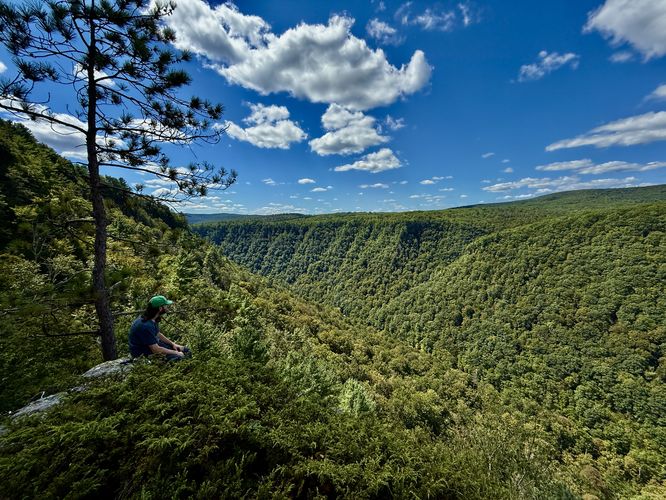
The Synder Point Vista Trail at Leonard Harrison State Park is a moderate 2.3-mile bushwhack loop hike that features a beautiful, but dangerous vista of the Pennsylvania Grand Canyon which includes views of Pine Creek and Colton Point State Park across the canyon. This hike is also 50% bushwhack, so hikers must be comfortable with hiking off-trail through prickers and other low-growing shrubs, along with reading topographical maps to plan their desired route.
Trail Description
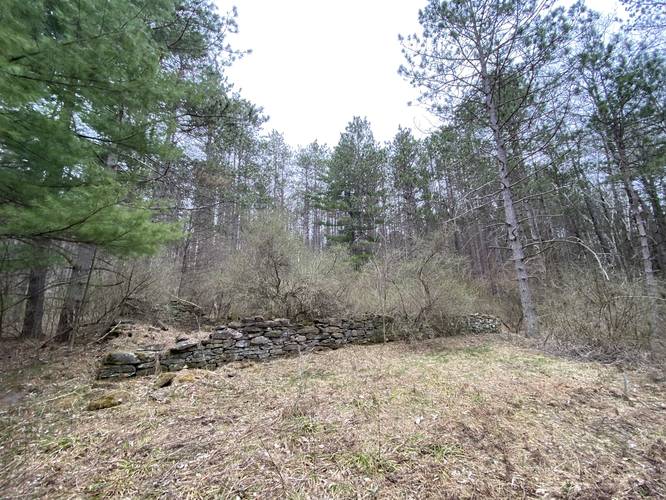
This trail begins along Snyder Point Road in Wellsboro, PA (see Parking notes for additional details) and follows a deer trail along the edge of a private property through state forest land to reach an old logging grade. The first 0.1-miles of the trail leads down through some low-growing trees and then crosses an open field with some old, mostly-dead, evergreens. On the other side of this field is a metal gate with an old wooden sign that states "State Park Lands". Based on some history, the assumption here with the state park sign is that this trail was supposed to connect to the rest of Leonard Harrison State Park but was never completed. Please respect the private land owners next door and stay on public land here.
Hikers will then pass by the gate to continue following an old grade, likely once used for logging, while following a beautiful Red Pine plantation.
First Junction - mile 0.35
Hikers will reach a trail junction around mile 0.35 where they can choose to take a right-hand turn or continue straight which will lead into the bushwhack. For this track, we stayed left at the junction to continue on toward the bushwhack; however, hikers may or may not find doing this loop in the opposite direction to be easier.
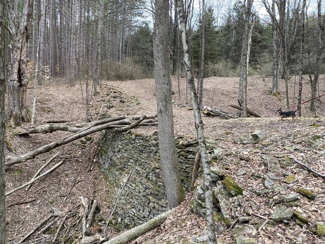
Stone Bridge and old Foundation - mile 0.4
Just after the first junction is a large stone bridge that was likely constructed for logging operations long ago. This large bridge is interesting because one side is about 15-feet tall which drops-off to a small creek below, while the other side has been built-up with silt and soil, so it's not much more than a couple of feet "deep" on the northern side of the bridge. Just after the bridge, hikers will find an old foundation located just upstream. After visiting the foundation, the bushwhack begins.
Bushwhack to the Canyon Rim - miles 0.45 to 1.3
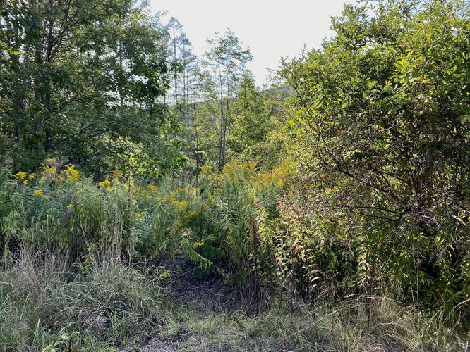
From approximately mile 0.45 to mile 1.3, hikers will no longer be following a trail and will need to bushwhack their way over to the Canyon rim. The easiest way to begin this bushwhack is to head directly into the Red Pine plantation to follow the cleared-out understory of the pines. This is the easiest section of the bushwhack, with the exception of the pricker / thorn / briar bushes. Once on the other side of the Red Pine plantation, hikers will need to follow deer trails while bushwhacking their way northwest. We hiked this section by mostly following deer trails until we reached a more open part of the understory, closer to the Canyon rim.
Canyon rim to Snyder Point Vista
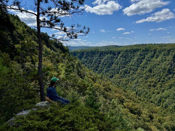
Once you bushwhack your way to the Canyon rim, the hike north to Snyder Point Vista is much easier as the forest floor is a bit more open, but hikers should take caution of the extremely steep and dangerous cliff sides that the Canyon rim has to offer. If you trip down the Canyon rim here, it may be the last hike you ever take, so watch your steps. Around mile 1.3, hikers will finally reach Snyder Point Vista which, as of April 2021, is a small overlook of Pennsylvania's Grand Canyon with views of Pine Creek and Colton Point State Park within the PA Grand Canyon. The Snyder Point Vista is a beautiful cutout within the pine trees, but the slope of the terrain here is not the safest and the view you get is not very big or open as it probably used to be. Watch your step and do not get too close to the edge of the overlook to prevent injuries.
Hiking Back from Snyder Point Vista
From Synder Point Vista, hikers will need to continue bushwhacking for a while longer. Hikers will want to continue heading north near the Canyon rim. About 0.1-miles north from Synder Point Vista, hikers will find what looks like a split in the forest - here is an old logging grade that slopes downhill. Hikers will want to follow this for a very short while before cutting back to head east - as a bushwhack hike. Here, it's important to follow your topographical map to ensure you are hiking in between two small hills, while heading east. Continue hiking east until you reach yet another Red Pine plantation. This Red Pine plantation has an unmarked and unblazed trail that cuts through it from south to north - hop on this trail to head south. Continue following this trail to reach the first trail junction mentioned in the notes previously. At that junction, take a left-hand turn to head back out to parking.
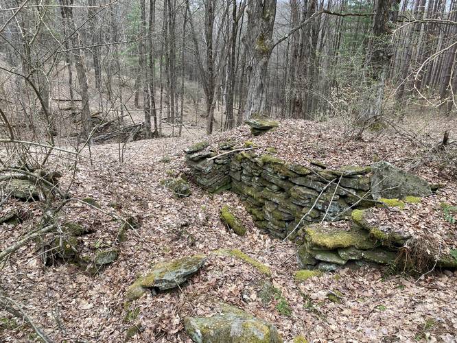
Old Foundation
Around mile 1.75, hikers will reach another old foundation, but this time it's located along a creek within the northern Red Pine plantation. The foundation is fairly large, so it must have been an impressive structure, either someone's old house or a large old barn.
Parking
Hikers will find a small parking turnout at the coordinates provided along Snyder Point Rd / SR3004 in Wellsboro, PA. The lot is large enough to fit a few vehicles.
Pets
Dogs are allowed if leashed; however, the bushwhack may be a challenge for some dogs. We had to pick up our 20lbs dog in some of the bushwhack sections to make hiking easy for everyone.
Camping
Since this trail technically follows a tract of land that's part of Leonard Harrison State Park, no camping is allowed - this means off-trail / dispersed / backcountry / primitive camping is not permitted.
Warnings
Bushwhacking: This trek leads through sections of forest where no trail is present. Bring a map and topographical-reading skills to ensure your safety on this hike.
Timber Rattlesnakes: The Timber Rattlesnake lives in these woods and is active between the end of April and the end of September. Bushwhacking through these woods may lead to finding a rattler. Watch your steps and hike at your own risk.
Canyon rim cliffs: This hike follows sections of the PA Grand Canyon rim, which has plenty of sheer drops where, if you fall, you will get seriously injured or die. Hike at your own risk.
Trail Description
This trail begins along Snyder Point Road in Wellsboro, PA (see Parking notes for additional details) and follows a deer trail along the edge of a private property through state forest land to reach an old logging grade. The first 0.1-miles of the trail leads down through some low-growing trees and then crosses an open field with some old, mostly-dead, evergreens. On the other side of this field is a metal gate with an old wooden sign that states "State Park Lands". Based on some history, the assumption here with the state park sign is that this trail was supposed to connect to the rest of Leonard Harrison State Park but was never completed. Please respect the private land owners next door and stay on public land here.
Hikers will then pass by the gate to continue following an old grade, likely once used for logging, while following a beautiful Red Pine plantation.
First Junction - mile 0.35
Hikers will reach a trail junction around mile 0.35 where they can choose to take a right-hand turn or continue straight which will lead into the bushwhack. For this track, we stayed left at the junction to continue on toward the bushwhack; however, hikers may or may not find doing this loop in the opposite direction to be easier.
Stone Bridge and old Foundation - mile 0.4
Just after the first junction is a large stone bridge that was likely constructed for logging operations long ago. This large bridge is interesting because one side is about 15-feet tall which drops-off to a small creek below, while the other side has been built-up with silt and soil, so it's not much more than a couple of feet "deep" on the northern side of the bridge. Just after the bridge, hikers will find an old foundation located just upstream. After visiting the foundation, the bushwhack begins.
Bushwhack to the Canyon Rim - miles 0.45 to 1.3
From approximately mile 0.45 to mile 1.3, hikers will no longer be following a trail and will need to bushwhack their way over to the Canyon rim. The easiest way to begin this bushwhack is to head directly into the Red Pine plantation to follow the cleared-out understory of the pines. This is the easiest section of the bushwhack, with the exception of the pricker / thorn / briar bushes. Once on the other side of the Red Pine plantation, hikers will need to follow deer trails while bushwhacking their way northwest. We hiked this section by mostly following deer trails until we reached a more open part of the understory, closer to the Canyon rim.
Canyon rim to Snyder Point Vista
Once you bushwhack your way to the Canyon rim, the hike north to Snyder Point Vista is much easier as the forest floor is a bit more open, but hikers should take caution of the extremely steep and dangerous cliff sides that the Canyon rim has to offer. If you trip down the Canyon rim here, it may be the last hike you ever take, so watch your steps. Around mile 1.3, hikers will finally reach Snyder Point Vista which, as of April 2021, is a small overlook of Pennsylvania's Grand Canyon with views of Pine Creek and Colton Point State Park within the PA Grand Canyon. The Snyder Point Vista is a beautiful cutout within the pine trees, but the slope of the terrain here is not the safest and the view you get is not very big or open as it probably used to be. Watch your step and do not get too close to the edge of the overlook to prevent injuries.
Hiking Back from Snyder Point Vista
From Synder Point Vista, hikers will need to continue bushwhacking for a while longer. Hikers will want to continue heading north near the Canyon rim. About 0.1-miles north from Synder Point Vista, hikers will find what looks like a split in the forest - here is an old logging grade that slopes downhill. Hikers will want to follow this for a very short while before cutting back to head east - as a bushwhack hike. Here, it's important to follow your topographical map to ensure you are hiking in between two small hills, while heading east. Continue hiking east until you reach yet another Red Pine plantation. This Red Pine plantation has an unmarked and unblazed trail that cuts through it from south to north - hop on this trail to head south. Continue following this trail to reach the first trail junction mentioned in the notes previously. At that junction, take a left-hand turn to head back out to parking.
Old Foundation
Around mile 1.75, hikers will reach another old foundation, but this time it's located along a creek within the northern Red Pine plantation. The foundation is fairly large, so it must have been an impressive structure, either someone's old house or a large old barn.
Parking
Hikers will find a small parking turnout at the coordinates provided along Snyder Point Rd / SR3004 in Wellsboro, PA. The lot is large enough to fit a few vehicles.
Pets
Dogs are allowed if leashed; however, the bushwhack may be a challenge for some dogs. We had to pick up our 20lbs dog in some of the bushwhack sections to make hiking easy for everyone.
Camping
Since this trail technically follows a tract of land that's part of Leonard Harrison State Park, no camping is allowed - this means off-trail / dispersed / backcountry / primitive camping is not permitted.
Warnings
Bushwhacking: This trek leads through sections of forest where no trail is present. Bring a map and topographical-reading skills to ensure your safety on this hike.
Timber Rattlesnakes: The Timber Rattlesnake lives in these woods and is active between the end of April and the end of September. Bushwhacking through these woods may lead to finding a rattler. Watch your steps and hike at your own risk.
Canyon rim cliffs: This hike follows sections of the PA Grand Canyon rim, which has plenty of sheer drops where, if you fall, you will get seriously injured or die. Hike at your own risk.