The Smiths Knob Hike at Loyalsock State Forest near Barbours, Pennsylvania is a hard 4-mile out-and-back hike that leads to a stunning vista stop Smiths Knob.
Hike Description
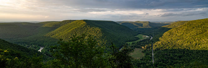
This hike follows the Loyalsock Trail starting at the parking lot on Little Bear Creek road. The hike is 2 miles one way with about 1,200 feet of elevation gain. The hike starts with a climb from the road and traverses through mountain laurel as you gain elevation. It levels out near Helen's Window with a view of the Loyalsock Valley for sometime before the final steep climb to Smiths Knob.
I did this trip as an after dinner short backpacking outing and camped at the Knob and came back out in the morning for about a 4 mile total hike.
Parking
Hikers will find a parking lot along Little Bear Creek road at the coordinates provided. From the parking lot, hikers will follow the Loyalsock Trail.
Pets
Dogs are allowed if leashed and should be cleaned up after.
Camping & Backpacking
While there are no designated or pre-defined campsites along this trail, backcountry / primitive / dispersed camping is allowed within Loyalsock State Forest. Please follow all state forest rules and regulations if planning to camp.
Difficulty
Some hikers may find this hike to be moderate, but the average hiker will likely find the steep elevation within short mileage sections more challenging, hence the Hard difficulty.
Warning
Timber Rattlesnake: This area is home to the Timer Rattlesnake which can often be found roaming the forest floors between late April and early October each year. Keep an eye out and if found, please give them plenty of space.
Hike Description
This hike follows the Loyalsock Trail starting at the parking lot on Little Bear Creek road. The hike is 2 miles one way with about 1,200 feet of elevation gain. The hike starts with a climb from the road and traverses through mountain laurel as you gain elevation. It levels out near Helen's Window with a view of the Loyalsock Valley for sometime before the final steep climb to Smiths Knob.
I did this trip as an after dinner short backpacking outing and camped at the Knob and came back out in the morning for about a 4 mile total hike.
Parking
Hikers will find a parking lot along Little Bear Creek road at the coordinates provided. From the parking lot, hikers will follow the Loyalsock Trail.
Pets
Dogs are allowed if leashed and should be cleaned up after.
Camping & Backpacking
While there are no designated or pre-defined campsites along this trail, backcountry / primitive / dispersed camping is allowed within Loyalsock State Forest. Please follow all state forest rules and regulations if planning to camp.
Difficulty
Some hikers may find this hike to be moderate, but the average hiker will likely find the steep elevation within short mileage sections more challenging, hence the Hard difficulty.
Warning
Timber Rattlesnake: This area is home to the Timer Rattlesnake which can often be found roaming the forest floors between late April and early October each year. Keep an eye out and if found, please give them plenty of space.