Loading...

🎉 Claim your Free 7-Day Supporter Trial to Unlock Exclusive Perks. Learn more.

Slim Shad Point Trail

The Slim Shad Point Trail is an easy 0.6-mile out-and-back trail located on Bridge St in Holyoke, Massachusetts.

The entrance is just before the bridge, there is a sign for the The Robert E. Barrett Fishway. The trailhead is located just beyond the entrance, parking is provided by the guardrail. You can park here and walk down the paved switchback path leading down a small slope to the base of the bridge. There is a one "overlook" along the path providing a small view of some sort of spillway/drainage.

Once at the bottom of the path, you may choose to continue onto the point under and beyond the bridge. There are no marking for the trail since it is very short, you are free to roam around the sandy area and enjoy views of the Connecticut River and the Holyoke Dam.

Beyond the parking for the trail is the entrance to the fishway itself. There is a self-guided tour of the the dam and fishway, or you can ask for a guided tour at no cost.

Fishing: This is a very popular fishing spot and swimming is prohibited.

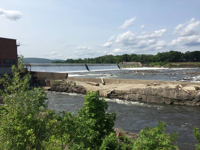
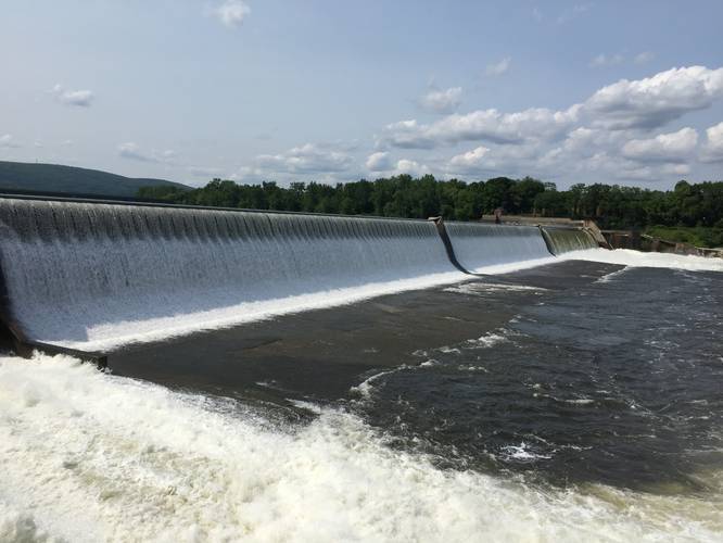
Waterfall: The Holyoke Dam is the waterfall listed; however, it's easier to reach the dam by driving down the road west to the end and walking over to the falls. You may be able to reach the dam from this trail, but it's more difficult.
Explore 207 trails near Holyoke, MA

Know Before You Go

  • The Slim Shad Point Trail is a short, easy walk offering views of the Connecticut River and Holyoke Dam from a sandy point.
  • Parking is along the guardrail near the Robert E. Barrett Fishway entrance on Bridge St in Holyoke, MA.
  • The trail provides access to a popular fishing spot and a self-guided tour of the Holyoke Dam and fishway.
Interactive topographic map for Slim Shad Point Trail located in Holyoke, MA. Click the "View Map" button to load GPS coordinates and trail markers.
Get directions
Distance
0.6 mi
Difficulty
Easy
Type
Out-and-Back
Est. Time
18 min
Elev. Gain
7'
Rating
0.0
Added
June 10, 2019
Updated
January 23, 2020

Weather Forecast

Overnight
Low 58°F
Slight Chance Rain Showers
Sunday
High 84°F
Sunny
Sunday Night
Low 54°F
Mostly Clear
Monday
High 82°F
Mostly Sunny
Monday Night
Low 60°F
Mostly Clear
Tuesday
High 93°F
Mostly Sunny then Slight Chance Showers And Thunderstorms
Tuesday Night
Low 68°F
Slight Chance Showers And Thunderstorms then Partly Cloudy
Wednesday
High 94°F
Chance Rain Showers then Chance Showers And Thunderstorms
Wednesday Night
Low 54°F
Showers And Thunderstorms Likely
Thursday
High 73°F
Partly Sunny
Thursday Night
Low 47°F
Partly Cloudy
Friday
High 72°F
Partly Sunny
Friday Night
Low 48°F
Mostly Cloudy
Saturday
High 71°F
Slight Chance Rain Showers
Loading...
Total Change
7'
Ascent
7'
Descent
7'
Loading...

Download the GPX Data for Offline Use

Supporters get exclusive access to download trail routes to the MyHikes app for offline use. Stay prepared on your adventure, even without an internet connection! Become a Supporter today to unlock this feature and hike with confidence.

Download Slim Shad Point Trail GPX Data to the MyHikes Mobile App

Features

Vista / Lookout Point
Dogs
Waterfalls
Water Source

Points of interest

  1. Parking

    42.210537, -72.597932
  2. Main Trailhead

    42.210569, -72.597859
  3. View of the Holyoke Dam

    42.211181, -72.601394
    View of the Holyoke Dam
  4. Adjacent to the Holyoke Dam

    42.211978, -72.602364
    Adjacent to the Holyoke Dam

Safety information

For your own safety: plan ahead, let someone know where you'll be, and hike at your own risk.

Availability

All seasons

Surface type

Paved

Trip Reports (Reviews)

Your opinion matters! Be the first to rate this trail.

Ready to help fellow hikers? Add a trip report to share your experience!

No community routes found. To add your own hike as a Community Route for this Trail guide, leave a Trip Report with an attached GPX file.

You May Also Like

Colorado's Million Dollar Highway - Plan a day's drive adventure along the iconic Million Dollar Highway in Colorado. Explore the best short trails, roadside stops, waterfalls, vistas, ghost towns, and hot springs within a ~6 hour road trip.
Explore

Colorado's Million Dollar Highway

Plan a day's drive adventure along the iconic Million Dollar Highway in Colorado. Explore the best short trails, roadside stops, waterfalls, vistas, ghost towns, and hot springs within a ~6 hour road trip.

Read
Glacier's Going-to-the-Sun Road - Discover the breathtaking beauty of Glacier National Park along the iconic Going-to-the-Sun Road. From stunning roadside stops to picturesque waterfalls and vistas, this engineering marvel offers endless opportunities for exploration.
Explore

Glacier's Going-to-the-Sun Road

Discover the breathtaking beauty of Glacier National Park along the iconic Going-to-the-Sun Road. From stunning roadside stops to picturesque waterfalls and vistas, this engineering marvel offers endless opportunities for exploration.

Read
🍪 We use cookies to learn about site usage and to serve map tiles. You may block cookies manually in the browser. By continuing you agree. Learn more