Sleeping Bear Point at Sleeping Bear Dunes National Lakeshore in Glen Arbor, Michigan is an easy 0.7-mile out-and-back hike that leads to the lookout point, Sleeping Bear Point, which provides views of Lake Michigan, North Manitou Island, and South Manitou Island.
Trails
This hike follows a small section of the Sleeping Bear Point Trail. Note that the Sleeping Bear Point Trail is a 2.8-mile loop, while this is just a small out-and-back section hike to the lakeshore.
Hike Description
This hike begins at the main trailhead for the Sleeping Bear Point Trail and follows the path heading west from the trailhead. Hikers will start off walking on a sandy path that leads uphill to reach the dunes. Just a couple hundred feet from the trailhead is a right-hand turn that heads towards Sleeping Bear Point.
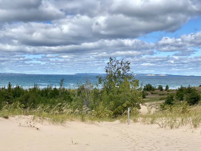
After taking the turn, hikers will be walking within the dunes in a small "valley" where the steep sandy dunes surround you as you make your way north to reach the lake shore. Eventually a view of Lake Michigan and the Manitou Islands (North and South) will come into view as the dunes flatten a bit. Here, the trail leads down to the shores of Lake Michigan.
Sleeping Bear Point Vista - Mile 0.35
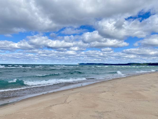
At the end of the trail, on the beach, lies Sleeping Bear Point. Hikers will get views of the tall sand dunes sitting alongside Lake Michigan's light-blue / turquoise waters. Looking north sit two islands - North and South Manitou Island with their sandstone cliffs visible from ~10-miles away.
Parking & Fees
Hikers will find parking at the coordinates provided. The lot is large enough to fit about a dozen vehicles. As of September 2022, there was a $25 entry fee which is also good for the Pierce Stocking Scenic Drive, which provides more hiking and vista opportunities at the park; however, there's no pay station or check-in at this trailhead.
Pets
Dogs are not allowed on this trail.
Warnings
Rip currents: According to the signs posted, the waters here are known to have a rip current / rip tide. It's best to avoid swimming here.
Trails
This hike follows a small section of the Sleeping Bear Point Trail. Note that the Sleeping Bear Point Trail is a 2.8-mile loop, while this is just a small out-and-back section hike to the lakeshore.
Hike Description
This hike begins at the main trailhead for the Sleeping Bear Point Trail and follows the path heading west from the trailhead. Hikers will start off walking on a sandy path that leads uphill to reach the dunes. Just a couple hundred feet from the trailhead is a right-hand turn that heads towards Sleeping Bear Point.
After taking the turn, hikers will be walking within the dunes in a small "valley" where the steep sandy dunes surround you as you make your way north to reach the lake shore. Eventually a view of Lake Michigan and the Manitou Islands (North and South) will come into view as the dunes flatten a bit. Here, the trail leads down to the shores of Lake Michigan.
Sleeping Bear Point Vista - Mile 0.35
At the end of the trail, on the beach, lies Sleeping Bear Point. Hikers will get views of the tall sand dunes sitting alongside Lake Michigan's light-blue / turquoise waters. Looking north sit two islands - North and South Manitou Island with their sandstone cliffs visible from ~10-miles away.
Parking & Fees
Hikers will find parking at the coordinates provided. The lot is large enough to fit about a dozen vehicles. As of September 2022, there was a $25 entry fee which is also good for the Pierce Stocking Scenic Drive, which provides more hiking and vista opportunities at the park; however, there's no pay station or check-in at this trailhead.
Pets
Dogs are not allowed on this trail.
Warnings
Rip currents: According to the signs posted, the waters here are known to have a rip current / rip tide. It's best to avoid swimming here.